
True square ortho-image manufacturing method

A technology of orthophotos and production methods, applied in image data processing, 3D modeling, instruments, etc., can solve problems such as difficult to meet requirements, achieve the effect of reducing the amount of data and calculation, and reducing the storage space of texture coordinates

Pending Publication Date: 2020-03-06
GUILIN UNIVERSITY OF TECHNOLOGY
View PDF8 Cites 1 Cited by
  • Summary
  • Abstract
  • Description
  • Claims
  • Application Information

AI Technical Summary

Problems solved by technology

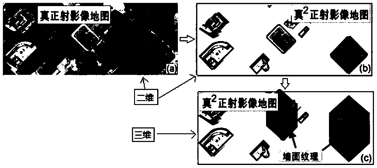
[0005] The inventor found in the research that the current urban real orthophoto map only provides 2D surface texture and 2D (XY) measurable information, so that it is difficult to meet the requirements for TOM in the future "digital / smart city" construction

Method used


Image

  • True square ortho-image manufacturing method
  • True square ortho-image manufacturing method
  • True square ortho-image manufacturing method

Examples


Embodiment Construction

[0026] In order to illustrate the technical solutions of the embodiments of the present invention more clearly, the accompanying drawings used in the embodiments will be briefly introduced below. It should be understood that the following drawings only show some embodiments of the present invention.

[0027] The basic steps of the method for making a true square orthophoto are as follows:

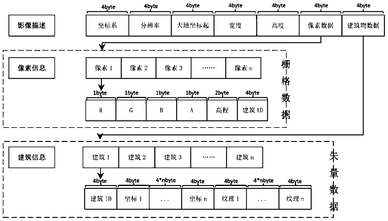
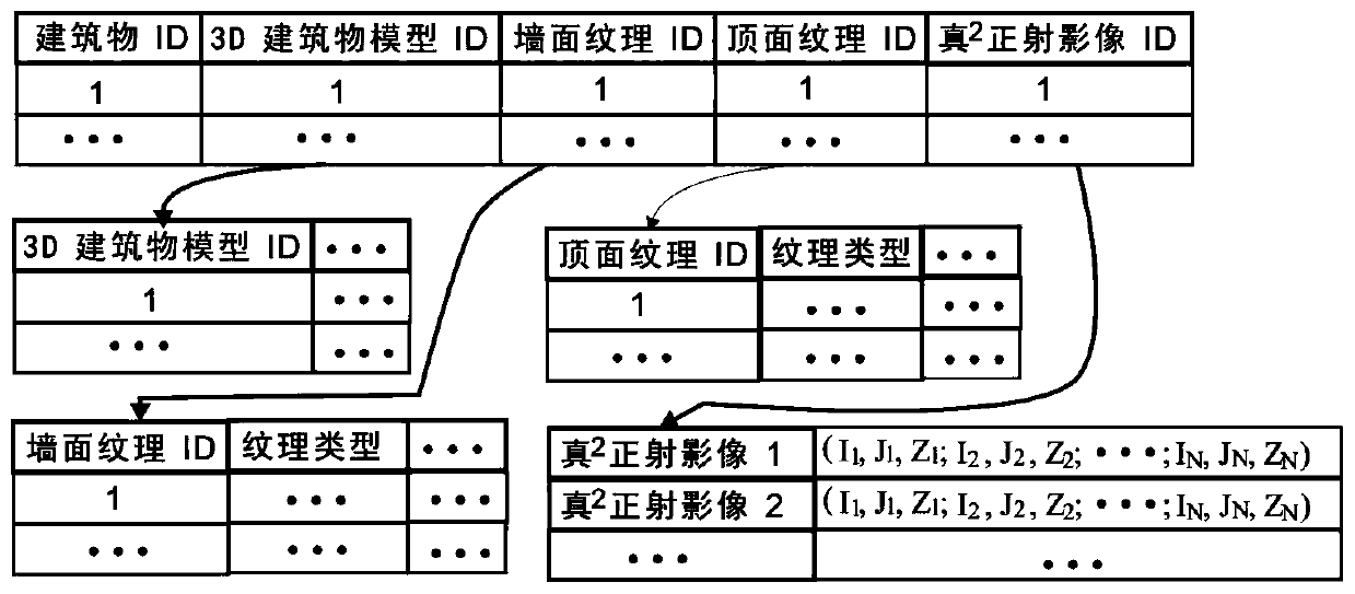
[0028] Step 1, T 2 The data structure design of OM, its data structure is as follows figure 1 As shown in , the true square orthophoto is composed of three parts, which are image metadata, pixel data and building data. The pixel data in the three parts of data is raster data, and the building data is vector data, and each pixel stores data in a binary variable-length field in the computer. The image description data includes the projected coordinate system, the starting point of the geodetic coordinates, the pixel resolution, etc., as well as the storage address of the pixel data and the ...


PUM


Abstract

A true square ortho-image (True Square Orthophoto Map-T2OM) is to add three-dimensional measurable information (x, y, z) and wall texture information on the basis of a true square ortho-image (true square orthophoto Map-TOM). Therefore, the two-dimensional geometric position (x, y) and the ground surface gray scale information of the real radiographic image are provided, and the three-dimensionalgeometric position (x, y, z) and the wall surface texture information are also provided. The manufacturing method of the T2OM comprises the following steps: (1) designing a data structure of the T2OM;(2) acquiring and storing the data of the T2OM; (3) creating a spatial index of the building T2OM; and (4) building three-dimensional modeling and editing. According to the manufacturing method of T2OM, selective seamless fusion of the real radiograph and the three-dimensional real landscape is achieved, and the 3D measurable urban landscape map embedded with the real texture image is developed,and the urgent requirement for the urban three-dimensional measurable map in digital / smart city construction is met.

Description

technical field [0001] The present invention relates to the field of making three-dimensional models of cities, in particular to true square orthophotos (T 2 OM) production method. [0002] technical background [0003] Digital Orthoimage Map-DOM is the core carrier of National Spatial Data Infrastructure (NSDI), Urban Spatial Data Infrastructure (USDI) and urban basic geographic information. Although traditional real orthophotos contain accurate surface position information and image texture information, and the information expressed has good interpretation, measurability and current situation, it cannot provide three-dimensional elevation information and wall texture information. [0004] With the construction of digital cities and smart cities, all sectors of society require USDI to have functions such as digitization, networking, optimized decision support, and 3D visualization. Especially for the establishment of a three-dimensional, dynamic, visualized realistic lands...

Claims


Application Information

Patent Timeline
IPC IPC(8): G06T17/00G06T17/05
CPCG06T17/00G06T17/05Y02P90/30
Inventor 周国清潘秋雨岳涛
Owner GUILIN UNIVERSITY OF TECHNOLOGY
Learn More