
Real-time mapping and positioning method, device, system and storage medium

A map and image technology, applied in the field of robotics, can solve problems such as difficult closed-loop detection of discrete points, increased error, and difficulty in obtaining high-precision dense maps.

Active Publication Date: 2020-09-22
深圳市智绘科技有限公司
View PDF13 Cites 0 Cited by
  • Summary
  • Abstract
  • Description
  • Claims
  • Application Information

AI Technical Summary

Problems solved by technology

Since the data acquired by the 3D lidar are discrete 3D points, it is difficult to perform closed-loop detection through the discrete points, resulting in a greatly increased error, and in a less structured environment such as a charging room, the lidar SLAM is very difficult for state estimation. prone to degradation until failure
Both visual-inertial SLAM and pure visual SLAM are camera-based sensor-based technical solutions. Vision-based methods can more easily perform loop detection through texture information, and are suitable for scenes with less structure, but vision-based SLAM systems are very difficult. It is difficult to obtain high-precision dense maps, which are essential in the planning and decision-making of mobile intelligent robots

Method used


Image

  • Real-time mapping and positioning method, device, system and storage medium
  • Real-time mapping and positioning method, device, system and storage medium
  • Real-time mapping and positioning method, device, system and storage medium

Examples


Embodiment Construction

[0076] In order to make the purpose, technical solutions and advantages of the embodiments of the present invention clearer, the technical solutions in the embodiments of the present invention will be clearly and completely described below in conjunction with the drawings in the embodiments of the present invention. Obviously, the described embodiments It is a part of embodiments of the present invention, but not all embodiments. Based on the embodiments of the present invention, all other embodiments obtained by persons of ordinary skill in the art without making creative efforts belong to the protection scope of the present invention.

[0077] In order to facilitate the understanding of the embodiments of the present invention, further explanations will be given below with specific embodiments in conjunction with the accompanying drawings, which are not intended to limit the embodiments of the present invention.

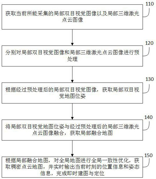
[0078] figure 1 A schematic flowchart of a real-time mapping...


PUM


Abstract

The embodiment of the present invention relates to a real-time mapping and positioning method, device, system, and storage medium. The method includes: acquiring current local binocular vision images and local three-dimensional laser point cloud images; Image and local 3D laser point cloud images are preprocessed; according to the preprocessed local binocular vision image, the local binocular vision map pose is obtained; the local binocular vision map pose is combined with the preprocessed local 3D laser Point cloud image fusion to obtain a local fusion map; according to the local fusion map, optimize the global consistency of the global map to obtain a dense point cloud map, and output the current location information and attitude information in real time to complete instant mapping and positioning. Through this method, a dense 3D point cloud image with global consistency is output, the current location information of itself can be determined in real time, and instant mapping and positioning can be completed.

Description

technical field [0001] The embodiments of the present invention relate to the technical field of robots, and in particular to a real-time mapping and positioning method, device, system and storage medium. Background technique [0002] As an interdisciplinary subject, intelligent robot integrates motion dynamics, system structure, sensing technology, control technology and other disciplines and technologies. Among these technologies, providing mobile robots for environmental perception and positioning is an essential process. Perception and positioning can feed back the current external environment information of the mobile robot and its own position and posture information in the environment, so as to further make corresponding decisions and control the motor to move forward. Real-time mapping and positioning, as an essential underlying technology for mobile intelligent robots, not only need to provide real-time positioning information for the robot, but also need to build a...

Claims


Application Information

Patent Timeline
Patent Type & Authority Patents(China)
IPC IPC(8): G01S17/89G01S17/02G06T7/521G06T7/55G06T7/73
CPCG01S17/89G06T7/521G06T7/55G06T7/73G06T2207/10016G06T2207/10028G06V20/64G06V20/10G06V10/457G06V10/757G06V10/462G06F18/2135G06F18/22G06F18/251G06T7/74G06T7/13G06T7/248G06T2207/20221
Inventor 李学万熊伟成张亮杨双
Owner 深圳市智绘科技有限公司
Learn More