A multi-layer equivalent source extension and data conversion method for gravity data
A gravity data and conversion method technology, applied in the field of gravity exploration, can solve the problems of data continuation distance limitation, discontinuous grid division, poor continuation calculation accuracy, etc., and achieve the effect of high stability and precision
- Summary
- Abstract
- Description
- Claims
- Application Information
AI Technical Summary
Problems solved by technology
Method used
Image
Examples
Embodiment Construction
[0028] In order to make the purpose, technical solution and advantages of the present invention clearer, the embodiments of the present invention will be further described below in conjunction with the accompanying drawings.
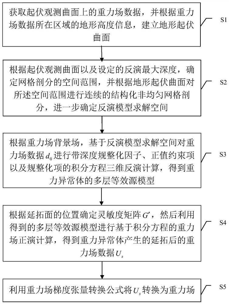
[0029] Please refer to figure 1 , the embodiment of the present invention provides a gravity data multi-layer equivalent source continuation and data conversion method, comprising the following steps:
[0030] S1. Input the gravity field data d on the undulating observation surface 0 , and according to the terrain height information of the area where the observation surface is located, a terrain relief surface is established; the gravity field data d 0 It can be gravity anomaly plumb data or gravity gradient tensor data, and this embodiment takes gravity anomaly plumb data as an example;
[0031] S2. Determine the spatial scope of grid division according to the terrain relief surface and the set inversion maximum depth, and perform continuous structure...
PUM
 Abstract
Description
Claims
Application Information
 - R&D
- Intellectual Property
- Life Sciences
- Materials
- Tech Scout
- Unparalleled Data Quality
- Higher Quality Content
- 60% Fewer Hallucinations
Browse by: Latest US Patents, China's latest patents, Technical Efficacy Thesaurus, Application Domain, Technology Topic, Popular Technical Reports.
© 2025 PatSnap. All rights reserved.Legal|Privacy policy|Modern Slavery Act Transparency Statement|Sitemap|About US| Contact US: help@patsnap.com


