Sampling point distribution method, device, electronic device and readable storage medium

An allocation method and sampling point technology, applied in the field of remote sensing, can solve the problems of low sampling efficiency, high cost, resource consumption, etc., and achieve the effect of reducing sampling cost, reducing frequency and improving sampling efficiency

Active Publication Date: 2022-01-21
INST OF GEOGRAPHICAL SCI & NATURAL RESOURCE RES CAS
View PDF0 Cites 0 Cited by
  • Summary
  • Abstract
  • Description
  • Claims
  • Application Information

AI Technical Summary

Problems solved by technology

[0005] The invention provides a sampling point allocation method, device, electronic equipment and readable storage medium, which are used to solve the problems of high cost, high resource consumption and low sampling efficiency in the existing sampling technology. The image is clustered to obtain the land cover clustering result map of the target area, and then based on the landscape heterogeneity of the target area, a square grid with an appropriate size is selected for the land cover clustering result map to cluster The result map is divided into grids, and the number of sampling points is assigned to each grid based on the landscape heterogeneity of the target area, which realizes grid division sampling, and allocates more in areas with high landscape heterogeneity than in landscape heterogeneity For sampling points in low-lying areas, the geographical grid division of the land cover cluster map through landscape heterogeneity can control the distribution of sampling points, reduce the frequency of repeated sampling points in similar areas, and improve sampling efficiency. At the same time, through Geographic meshing can effectively reduce costs

Method used


Image

  • Sampling point distribution method, device, electronic device and readable storage medium
  • Sampling point distribution method, device, electronic device and readable storage medium
  • Sampling point distribution method, device, electronic device and readable storage medium

Examples


Embodiment Construction

[0050] In order to make the purpose, technical solutions and advantages of the present invention clearer, the technical solutions in the present invention will be clearly and completely described below in conjunction with the accompanying drawings in the present invention. Obviously, the described embodiments are part of the embodiments of the present invention , but not all examples. Based on the embodiments of the present invention, all other embodiments obtained by persons of ordinary skill in the art without creative efforts fall within the protection scope of the present invention.

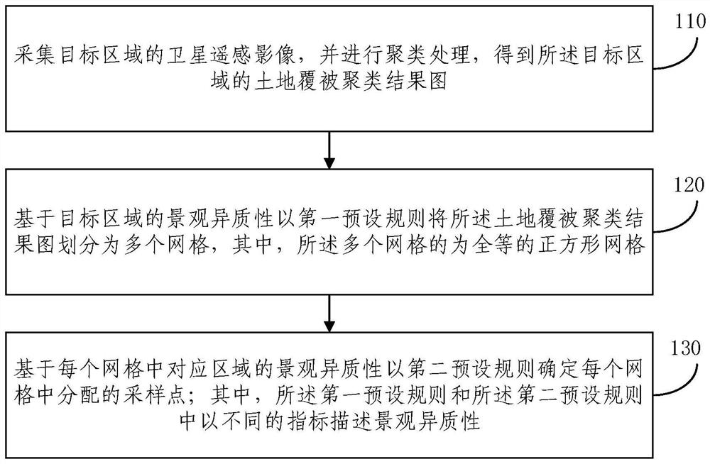
[0051] Due to the common problems of high cost, large resource consumption and low sampling efficiency in the existing sampling technology. Combine below Figure 1-Figure 7 A method for assigning sampling points based on landscape heterogeneity of the present invention is described. figure 1 A schematic flow chart of a sampling point allocation method based on landscape heterogeneity provid...


PUM


Abstract

The present invention provides a sampling point allocation method, device and electronic equipment based on landscape heterogeneity, comprising: collecting satellite remote sensing images of a target area, and performing clustering processing to obtain a land cover clustering result map of the target area ; Based on the landscape heterogeneity of the target area, the land cover clustering result map is divided into a plurality of grids with a first preset rule, wherein the plurality of grids are congruent square grids; based on The landscape heterogeneity of the corresponding area in each grid determines the sampling points allocated in each grid with a second preset rule; wherein, the first preset rule and the second preset rule use different Indicators describe landscape heterogeneity. The method, device and electronic equipment provided by the invention realize the distribution control of sampling points, reduce sampling cost and improve sampling efficiency.

Description

technical field [0001] The invention relates to the technical field of remote sensing, in particular to a sampling point allocation method, device, electronic equipment and a readable storage medium. Background technique [0002] Land cover classification mapping using remote sensing satellite data has been widely studied and used to produce land cover products. At present, a series of extensive studies have also been carried out on land cover accuracy assessment obtained from remote sensing image classification, including sampling design, reference data collection and statistical analysis, etc. The sampling design is used to obtain the distribution of the accuracy evaluation test set. These test sets used to evaluate the classification accuracy play a very important role in the accuracy evaluation. The sampling design method must be considered in the accuracy evaluation. A sample can reflect the statistical characteristics of an area and is a subset or part of an area. Sa...

Claims


Application Information

Patent Timeline
Patent Type & Authority Patents(China)
IPC IPC(8): G06V10/762G06T17/05G06T17/20
CPCG06T17/205G06T17/05G06F18/23
Inventor 黄翀
Owner INST OF GEOGRAPHICAL SCI & NATURAL RESOURCE RES CAS
Why Eureka
Try Eureka