Traffic reachability index optimization method applied to territorial space overall planning

A technology for overall planning and index optimization, applied in data processing applications, instruments, forecasting, etc., it can solve problems that cannot be directly used in traffic planning or national land space planning, the measurement of accessibility is extremely sensitive, and the land use factors of the starting point area are not considered, etc. problem, to achieve the effect of reducing human subjective influence and wide application range

Active Publication Date: 2022-01-28
广州市交通规划研究院有限公司
View PDF9 Cites 3 Cited by
  • Summary
  • Abstract
  • Description
  • Claims
  • Application Information

AI Technical Summary

Problems solved by technology

[0014] 2. Opportunity cumulative model: The determination of the travel cost threshold is too subjective, and it is assumed that all opportunities have the same attractiveness to travel individuals, without considering the differences in the attractiveness of different opportunities to different groups of people;
[0015] 3. Spatial interaction model: When the distance is small, the calculation of accessibility i

Method used


Image

  • Traffic reachability index optimization method applied to territorial space overall planning
  • Traffic reachability index optimization method applied to territorial space overall planning
  • Traffic reachability index optimization method applied to territorial space overall planning

Examples


Embodiment Construction

[0064] The present invention will be further described in detail below in conjunction with the accompanying drawings and embodiments.

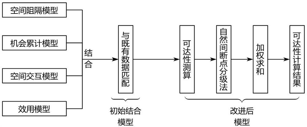
[0065] The application of the accessibility index evaluation method in the overall planning of land space mainly includes the following two steps: 1) Establishing the traffic accessibility index system; 2) Constructing the traffic accessibility deepening model.

[0066] The traffic accessibility index system includes a variety of indicators related to traffic factors and land use factors. The main data sources include traditional traffic data, land use data and emerging big data. The main process of the traffic accessibility deepening model is the selection and calculation of indicators and initial models, the classification of natural discontinuities, and the calculation of regional accessibility weights.

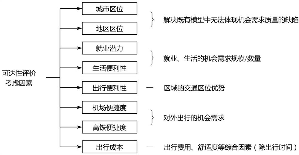
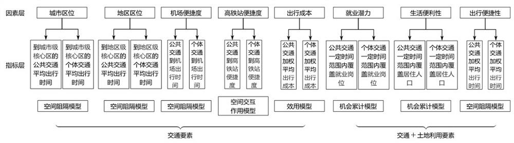
[0067] 1. Establish traffic accessibility index system

[0068] Such as figure 1 , 3 As shown, eight factors are selected as the input...


PUM


Abstract

The invention discloses a traffic reachability index optimization method applied to territorial space overall planning. The method comprises the following steps: S1, establishing a traffic reachability index system; and S2, constructing a traffic reachability deepening model, comprising S2.1, selecting a traffic reachability input index and a traffic reachability initial model, and measuring and calculating the reachability, S2.2, grading by a natural discontinuity point grading method, and S2.3, carrying out weighted calculation on the reachability of the region. According to the method, a traffic reachability deepening analysis model and a new reachability index system are established, and a quantitative decision reference or a scheme evaluation result is provided for land space planning and land utilization planning, urban overall planning and main functional area planning included in the land space planning. The method can be used as an intermediary index for cooperation of traffic planning and territorial space planning.

Description

technical field [0001] The invention belongs to the technical field of traffic accessibility evaluation, and in particular relates to a traffic accessibility index optimization method applied to the overall planning of land space. Background technique [0002] The role of traffic accessibility assessment [0003] In the field of transportation planning, transportation accessibility mainly refers to the degree of convenience for people in a certain area to use a certain mode of transportation to obtain opportunities such as employment, school, and shopping. On the one hand, traffic accessibility reflects the possibility of travelers occupying traffic resources under different land use conditions; on the other hand, traffic accessibility can reflect the opportunities of travelers to participate in specific activities or use public facilities. [0004] In the "multi-plan integration" national land space planning system, transportation planning needs to be coordinated with land...

Claims


Application Information

Patent Timeline
IPC IPC(8): G06Q10/04G06Q10/06G06Q50/26
CPCG06Q10/04G06Q10/06393G06Q10/067G06Q50/26
Inventor 马小毅刘明敏江雪峰宋程李磊金安陈先龙卢泰宇何鸿杰刘新杰丁晨滋徐良
Owner 广州市交通规划研究院有限公司
Why Eureka
Try Eureka