Electronic map grid drawing method and system in grid data system

A grid data and electronic map technology, applied in image data processing, geographic information database, structured data retrieval, etc., can solve problems such as unfavorable business operations, inaccurate polygon grids, and inability to form polygon grid systems. Support business operation, accurate effect of polygon mesh

Active Publication Date: 2022-05-13
上海歆广数据科技有限公司
View PDF9 Cites 0 Cited by
  • Summary
  • Abstract
  • Description
  • Claims
  • Application Information

AI Technical Summary

Problems solved by technology

In the process of creating an electronic map under the conventional administrative management system, the boundary of the polygon grid of the next level located on the inner side of the polygon grid of the previous level may extend beyond the boundary of the polygon grid of the previous level, or the boundary of the polygon grid of the previous level may appear. The boundary of the polygon mesh of the next level on the inner side of the polygon mesh of the level does not coincide with the boundary of the polygon mesh of the previous level, which leads to the inaccurate polygon mesh drawn, and the polygon mesh of the previous level is not realized. The polygon grid boundary of the lower level on the inner side of the grid completely coincides with the polygon grid boundary of the upper level, which cannot form a correct polygon grid system, which is not conducive to supporting subsequent business operations

Method used


Image

  • Electronic map grid drawing method and system in grid data system
  • Electronic map grid drawing method and system in grid data system
  • Electronic map grid drawing method and system in grid data system

Examples


Embodiment Construction

[0036] In order to make the purpose, technical solutions and advantages of the embodiments of the present invention clearer, the technical solutions in the embodiments of the present invention will be clearly and completely described below in conjunction with the drawings in the embodiments of the present invention. Obviously, the described embodiments It is a part of embodiments of the present invention, but not all embodiments. Based on the embodiments of the present invention, all other embodiments obtained by persons of ordinary skill in the art without making creative efforts belong to the protection scope of the present invention.

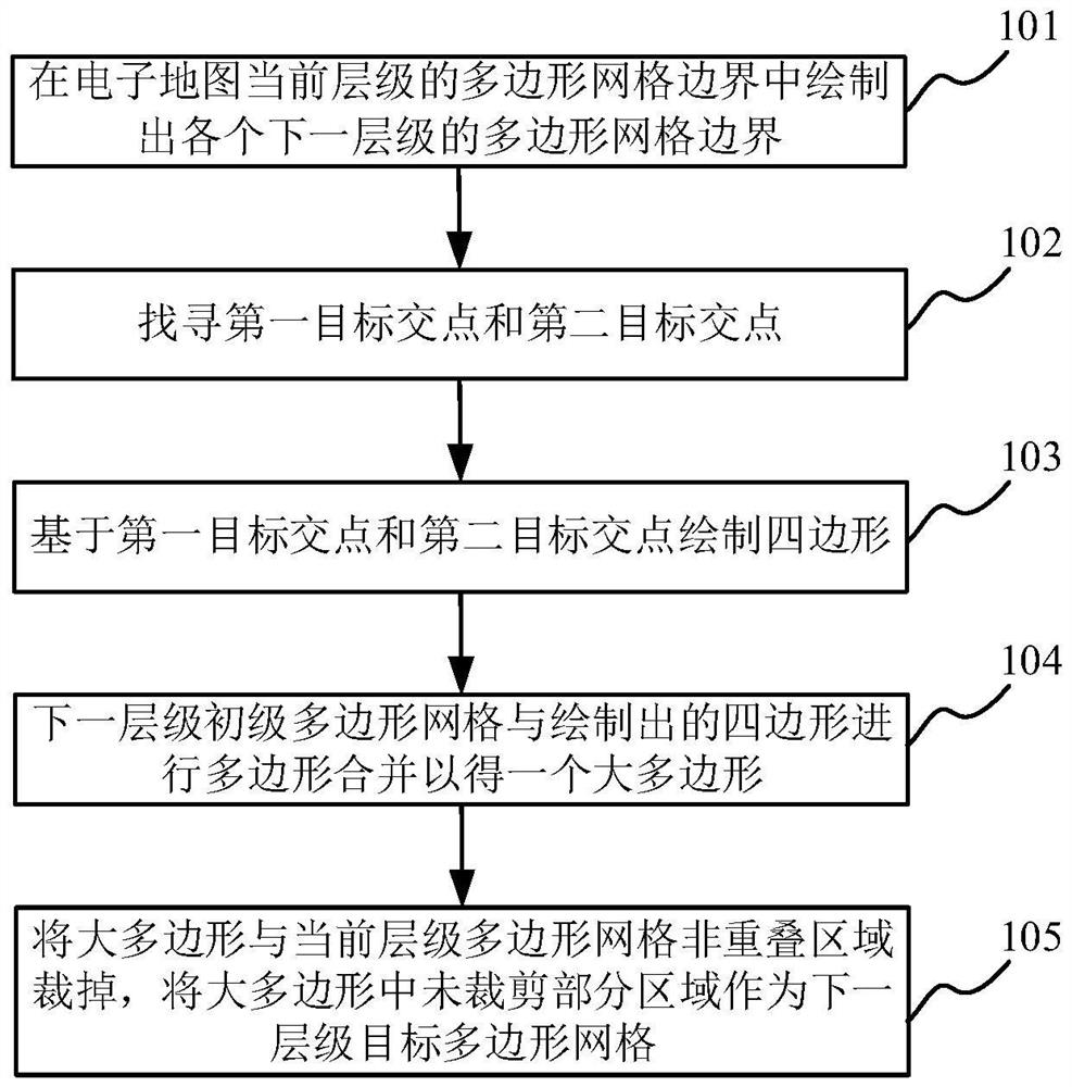
[0037] Such as figure 1 As shown, the present embodiment provides a method for drawing an electronic map grid in a grid data system, which includes the following steps:

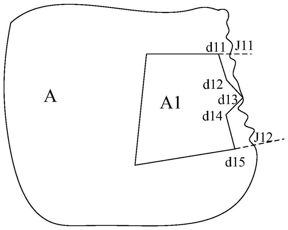
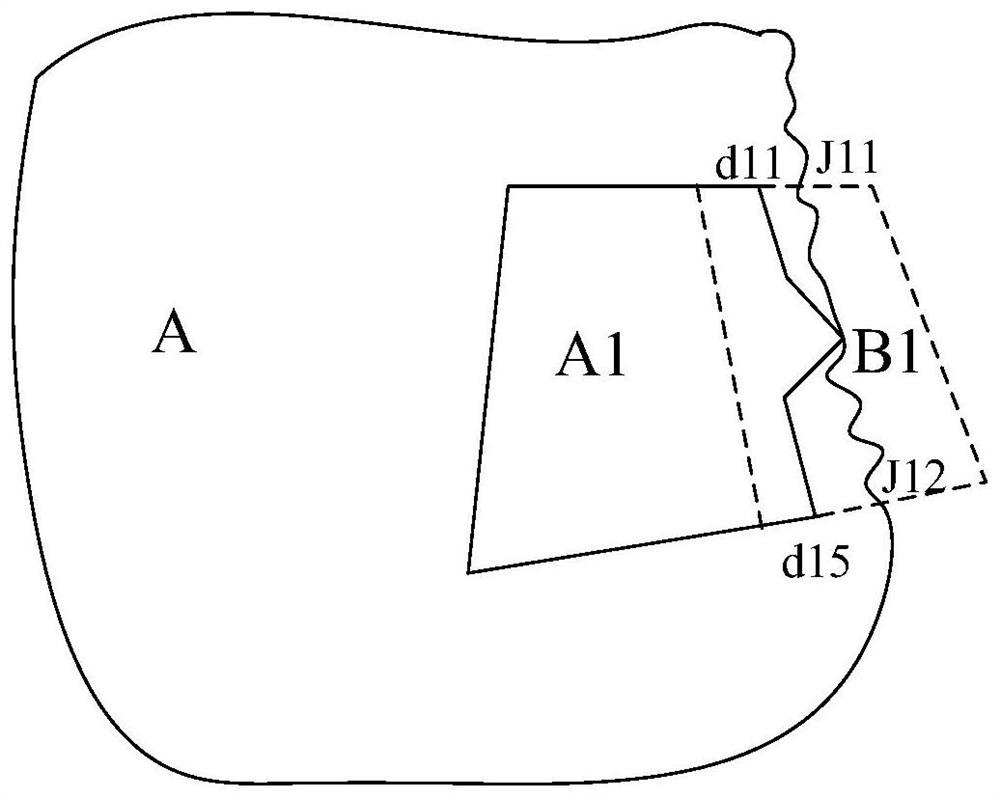
[0038] Step 101, automatic drawing: based on the boundary data of each lower level corresponding to the current level under the grid data system, draw the polygonal grid bo...


PUM


Abstract

The invention discloses a method and a system for drawing an electronic map grid in a grid data system. The method comprises the following steps of: drawing a primary polygonal grid boundary of each next level in a polygonal grid boundary of a current level of an electronic map based on boundary data of each next level; searching a first target intersection point and a second target intersection point; an edge passing through the first/second target intersection point or an extension line of the edge extends out of the boundary of the current-level polygonal mesh to serve as a first/second edge of a quadrangle to be drawn, and a connecting line between the first edge and the second edge and the end parts located out of the boundary of the current-level polygonal mesh serves as a third edge of the quadrangle; a connecting line between the first edge and the second edge is used as a fourth edge of the quadrangle, and the fourth edge is completely positioned in the polygonal grid of the next level; performing polygon combination on the polygon mesh of the next level and the quadrangle to obtain a large polygon; and cutting off a non-overlapping region of the large polygon and the current-level polygonal mesh, and taking the non-cut partial region in the large polygon as a next-level target polygonal mesh.

Description

technical field [0001] The invention relates to the technical field of electronic map creation, in particular to a method and system for drawing electronic map grids in a grid data system. Background technique [0002] In the existing conventional administrative management system (province-city-district / county-town-village), the electronic map is composed of polygonal grids of various sizes. In the process of creating an electronic map under the conventional administrative management system, the boundary of the polygon grid of the next level located on the inner side of the polygon grid of the previous level may extend beyond the boundary of the polygon grid of the previous level, or the boundary of the polygon grid of the previous level may appear. The boundary of the polygon mesh of the next level on the inner side of the polygon mesh of the level does not coincide with the boundary of the polygon mesh of the previous level, which leads to the inaccurate polygon mesh drawn...

Claims


Application Information

Patent Timeline
Patent Type & Authority Applications(China)
IPC IPC(8): G06T11/20G06T11/00G06F16/29
CPCG06T11/206G06T11/001G06F16/29
Inventor 刘臻姚云宵
Owner 上海歆广数据科技有限公司
Why Eureka
Try Eureka