Remote sensing satellite platform control and image correction method based on flutter information

An image correction and platform control technology, applied in the field of target recognition, can solve the problems of relative imaging position difference, failure to merge, and difficulty

Pending Publication Date: 2022-05-27
PLA PEOPLES LIBERATION ARMY OF CHINA STRATEGIC SUPPORT FORCE AEROSPACE ENG UNIV
View PDF2 Cites 0 Cited by
  • Summary
  • Abstract
  • Description
  • Claims
  • Application Information

AI Technical Summary

Problems solved by technology

[0004] The open invention patent with the patent number CN201711173663.3 discloses "a satellite platform flutter detection method based on TDICCD stitching area images", which estimates the satellite platform flutter by calculating the relative imaging position difference of the same target in two overlapping images information, but failed to integrate satellite platform control and image correction methods
The open invention patent with the patent number CN202110264265.2 discloses "a high-resolution remote sensing satellite flutter detection and modeling method based on collaborative multi-payload data". Modeling, this method is more difficult to implement

Method used


Image

  • Remote sensing satellite platform control and image correction method based on flutter information
  • Remote sensing satellite platform control and image correction method based on flutter information
  • Remote sensing satellite platform control and image correction method based on flutter information

Examples


Embodiment 1

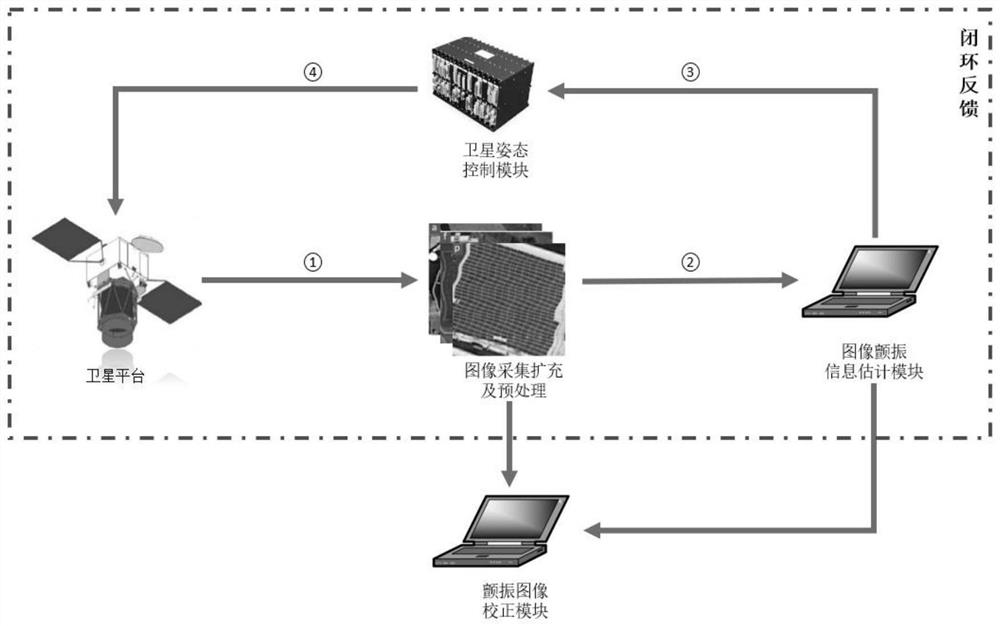
[0021] Embodiment 1 of the present invention, a remote sensing satellite platform based on flutter information control and image correction method thereof, see Figure 1 , follow the steps below:

[0022]Simulate satellite motion and construct flutter image data set, use the spacecraft attitude control full physical simulation system to achieve full physical simulation of the spacecraft attitude control system, the system is based on the triaxial air flotation platform to achieve the real simulation of the attitude dynamics of the spacecraft weightless state, through the complete integration of the real hardware components of the attitude control system, to complete the simulation of the spacecraft motion. The system is used to simulate satellite platform movements, install vibration generators on triaxial air flotation platforms, and attach optical cameras to vibration generators. The three-axis air flotation platform simulates the pitch and deflection movement of the satellite an...


PUM


Abstract

The invention discloses a remote sensing satellite platform control and image correction method based on flutter information. The method comprises the steps of simulating satellite motion and constructing a flutter image data set, expanding data volume through data enhancement, preprocessing flutter image data, extracting image flutter information by using a ResNet algorithm, feeding back the flutter information to a satellite attitude control system for control, and guiding a Transformer model to perform image correction by using the flutter information. In order to solve the technical problem that space tasks such as high-resolution reconnaissance cannot be clearly imaged due to limitation of high-frequency low-amplitude micro-vibration of a spacecraft, satellite flutter information is solved by using a flutter image, and a satellite platform is controlled and image correction network learning is guided by using the flutter information. Therefore, a satellite flutter estimation, attitude control feedback and image correction closed-loop system is built. The invention provides a satellite flutter information estimation and attitude control information feedback based on a ResNet algorithm and a flutter image correction intelligent method based on a Transform model, and the spatial information intelligent processing capability of China is effectively improved.

Description

Technical field [0001] The present invention relates to the field of object recognition, in particular to a remote sensing satellite platform control based on flutter information and an image correction method thereof. Background [0002] In space missions, remote sensing satellite Earth observation has extremely high military and commercial value, however, subject to the impact of high frequency and low amplitude micro-vibration of spacecraft, remote sensing satellites can not be clearly imaged, thus seriously restricting the use of remote sensing images. Satellite flutter is a kind of high-frequency low-amplitude micro-vibration that is difficult to detect and correct, which effectively estimates the satellite flutter information, controls the satellite platform according to the flutter information, and finally uses the relevant algorithm to correct the distortion remote sensing image, which can effectively solve the impact of satellite flutter on the remote sensing image. The ...

Claims


Application Information

Patent Timeline
Patent Type & Authority Applications(China)
IPC IPC(8): G05D1/08G06T5/00
CPCG05D1/0808G06T5/006G06T2207/20081G06T2207/20084G06T2207/10032
Inventor 任元叶瑞达王卫杰刘钰菲陈晓岑王松涛吴昊王丽芬
Owner PLA PEOPLES LIBERATION ARMY OF CHINA STRATEGIC SUPPORT FORCE AEROSPACE ENG UNIV
Why Eureka
Try Eureka