Calibration method for ultra-short baseline acoustic positioning system

A technology of ultra-short baseline and calibration method, which is applied in the direction of radio wave measurement system, positioning, measurement device, etc., and can solve problems such as systematic position deviation

Inactive Publication Date: 2006-09-27
THE FIRST INST OF OCEANOGRAPHY SOA
View PDF0 Cites 22 Cited by
  • Summary
  • Abstract
  • Description
  • Claims
  • Application Information

AI Technical Summary

Problems solved by technology

Therefore, these systematic errors must be calibrated out before working with an ultra-short b...

Method used


Image

  • Calibration method for ultra-short baseline acoustic positioning system
  • Calibration method for ultra-short baseline acoustic positioning system
  • Calibration method for ultra-short baseline acoustic positioning system

Examples


specific Embodiment

[0082] According to the calibration method of the present invention, enumerate the specific embodiment that tests in certain sea area as follows:

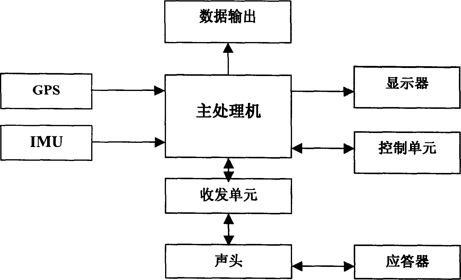
[0083] 1) Set each deviation to 0, fix the transponder on the bottom of the sea, and the ship sails around the transponder, and adopt the step a. described in the calibration method of the present invention to collect and store the data of GPS, IMU and ultra-short baseline measurement in total 326 Group.

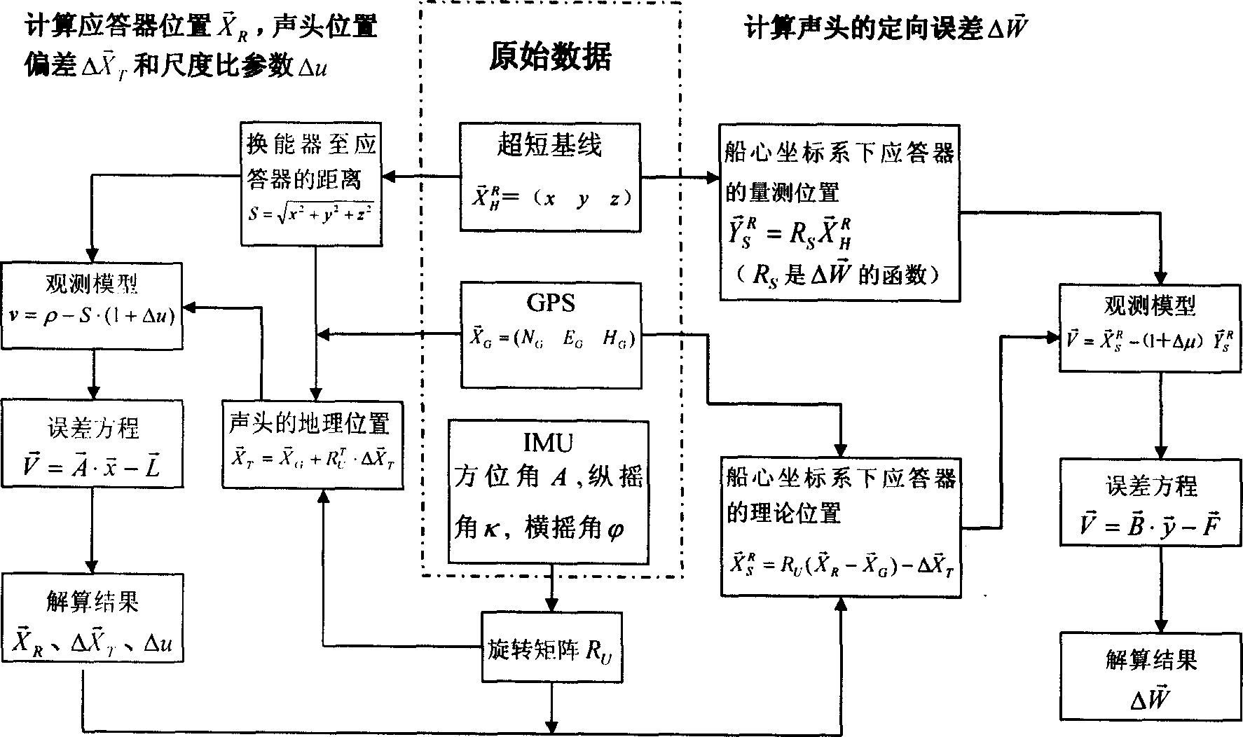
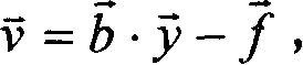
[0084] 2) After the data collection is completed, calculate the calibration data according to the b.-c. steps described in this calibration method, and the results are shown in Table 1.

[0085] 3) In order to prove the scientificity of the calibration method, output the geolocation data of the transponder calculated without calibration according to the d. step described in this calibration method, as shown in Table 2; according to the d. step described in this calibration method, the output is calibrated The calculated transpon...


PUM


Abstract

This invention relates to a calibration method for ultra-short baseline acoustic positioning system, which comprises a main processor, a transceiver, a control unit, an ultra-short base line sound head, an underwater target transponder, a GPS system and IMU device both arranged on survey ship body above water surface. The calibration method comprises: a. stores GPS data, ship attitude data and the geometrical distance from sound head to the transponder; b. inputs to compute the transponder position and the position error from the sound head to GPS antenna; c. calls the computation to compute the navigation error for sound head; d. outputs new computer program for high-precise positioning.

Description

technical field [0001] The invention relates to the improvement of detection equipment of a marine survey and measurement ship, in particular to a calibration method for an Ultra Short Base Line Acoustic Positioning System (Ultra Short Base Line Acoustic Positioning System), which belongs to the technical field of marine resource detection. Background technique [0002] In ocean surveys in the prior art, an ultra-short baseline hydroacoustic positioning system is often used to locate underwater towed bodies or other targets. The system includes: an ultra-short baseline sound head fixed below the water surface of the hull of the survey ship, a main processor, a transceiver unit, a control unit, an external GPS antenna positioning system installed above the water surface of the hull, and an inertial measurement device-IMU (Inertial Measurement Unit). )Wait. Due to the positional deviation between the ultra-short baseline sound head and the GPS antenna, it is impossible to com...

Claims


Application Information

Patent Timeline
IPC IPC(8): G01S5/18
Inventor 吴永亭刘焱雄周兴华唐秋华丁继胜杨龙
Owner THE FIRST INST OF OCEANOGRAPHY SOA
Why Eureka
Try Eureka