Point of interest spatial rating search method and system

a spatial rating and search method technology, applied in the field of point of interest spatial rating search method and system, can solve the problems of limited prior art search system, cumbersome and difficult, and achieve the effect of enhancing the accuracy of provided direction information, facilitating the accuracy and efficiency of direction information, and achieving the highest index respons

Inactive Publication Date: 2003-02-20
TELECOMM SYST INC
View PDF23 Cites 839 Cited by
  • Summary
  • Abstract
  • Description
  • Claims
  • Application Information

AI Technical Summary

Benefits of technology

0028] It is yet still another object of the invention to provide users directions from their current location to a desired POI that was provided from a search query. These directions can be provided in various formats, such as text, voice (i.e., speech directions), mapping of varying resolutions, etc., and may encompass additional information that may add to the accuracy of the provided direction information. In one embodiment, a user in a vehicle may require routable driving directions from their present location to the desired POI which incorporates various additional information that will aid in the accuracy and efficiency of the direction information, such as real-time traffic information and appropriate highway ramp or street turn restrictions that can be time dependent (i.e., right turn only from 7 AM to 5 PM). As an additional example, directions for a hiker seeking a POI, such as a camp ground, might require a routable hiking trail or directional information, such as the ability to provide azimuth, elevation, altitude, altitude difference, line-of-sight (LOS) distance, and curved earth LOS distance measurements, between the user and the destination POI, which can be delivered to the user in various formats, such as text, voice (i.e., speech directions), mapping of varying resolutions, etc.
0029] It is yet still another object of the invention to provide a method of indexing desired POIs based on their location relative to a pre-defined route and the user's current position information provided by a navigational device, such that POIs that are closer to the pre-defined route are given a higher priority index than POIs that are off the current pre-defined route and would require a considerable detour from the pre-defined route, or near the pre-defined route, but that have been passed by the navigational device. In one embodiment, a user that has defined a route from point A to point B and is navigating on the predefined route would want to find the highest rated restaurant in the nearby area for dinner within an area between point A and point B. Using a variety of aforementioned search methods, the search may return 4 restaurants that all have equal ratings and are all approximately the same driving distance from the navigational device's current position. However, only one restaurant's position is directly ahead on the pre-defined route of the navigational device, while 1 of the other 3 restaurants is behind the navigational device on the pre-defined route, and the other 2 are off the route on either side of the navigational device. Thus, the restaurant that is located nearest to the pre-defined route, closest to the navigational device, and on a portion of the pre-defined route which has not already been traversed and requires minimal or no deviation from the pre-defined route will have the highest indexed response, and is displayed in a rating window relative to the other restaurant ratings. In another embodiment, the system can provide the total off-route driving time necessary to reach the POI and then back to the pre-defined route for each indexed POI.

Problems solved by technology

Also, prior art search systems are limited in the type of POIs they can search against.
For example, a food establishment rating metric might include average price per entree or general price categories, such as inexpensive, moderate, very expensive, etc., while for a business bank such a field is inappropriate.
This allows users to read various ratings about a POI without having to initiate a search for the POI, which can be cumbersome and difficult on any device, especially a mobile device.

Method used


Image

  • Point of interest spatial rating search method and system
  • Point of interest spatial rating search method and system
  • Point of interest spatial rating search method and system

Examples


Embodiment Construction

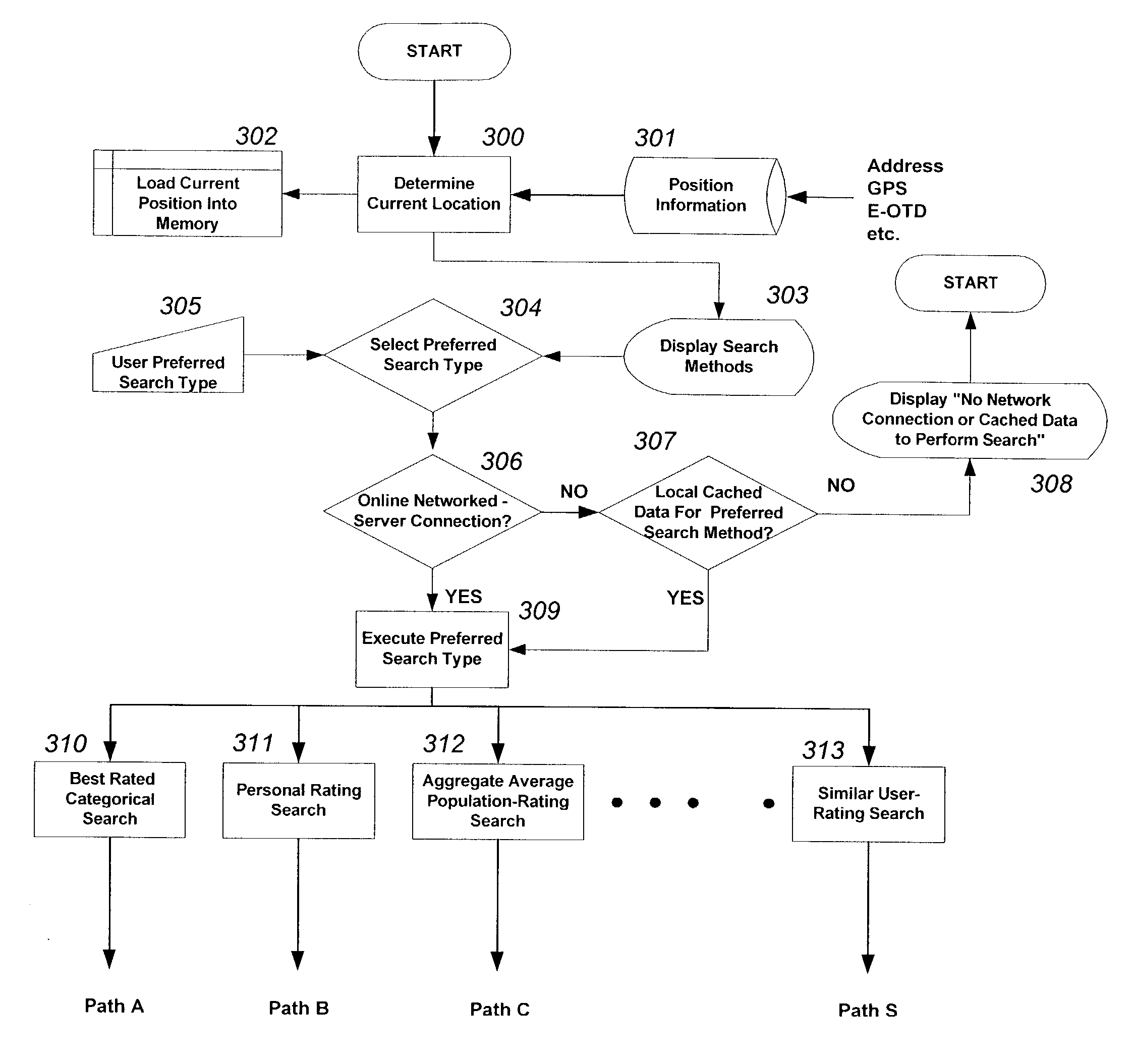
[0058] The embodiments of the present invention provide methods and systems for enabling a navigational device to search, rate, and navigate to various POIs from a navigational device's current position. The POI spatial rating search allows users to search for desired POIs based on a specified rating metric. In one embodiment, a user may want to find the closest seafood restaurant that is generally most popular with users that have previously rated such restaurants in the area. Additionally, that user may want to have real-time driving directions to the desired POI of interest, where the driving directions take into consideration street speed limits, traffic information, and street turn restrictions.

[0059] The present invention also provides a method and system for allowing users to rate specific POIs based on their current location and various rating categories, such as quality of service or decor, or average price per entree. In one embodiment, a user that has visited a POI can ra...


PUM


Abstract

The present invention is directed to a system and method for searching and retrieving location information associated with one or more points of interests, whereby the search criteria can be dependent upon the location of a point of interest with respect to the the real-time position of the user, and any preferences or search restrictions selected by the user, such as rating information about the point of interest. Upon selecting a point of interest from the search result, the user is then given further information regarding the selected point of interest, including but not limited to directions for traveling to the point of interest. Additionally, the present invention can provide to the user a proximity notification once the user is within a certain distance from the point interest. Finally, while at a point of interest, the user can provide to the system information regarding the point of interest, such as rating of the food of a restaurant, without having to specifically identify the point of interest as the system can self-identify the point of interest by using the position information of the user.

Description

[0001] Embodiments of the present invention claim priority from U.S. provisional patent application Serial No. 60 / 313,010 filed Aug. 16, 2001.[0002] 1. Field of Invention[0003] The present invention relates to a system and method for providing the capability for spatial searches used to find and rate points of interest (POI) information and items associated with various POIs, such as for finding the best restaurant, or for finding a specific book in a highly rated bookstore in the surrounding area.[0004] 2. Description of the Related Art[0005] Current rating search systems are based on static non-spatial searches that provide users with the ability to select only categorical searches that deal with specific inputted preferences. For instance, typical Internet-based rating systems allow users to search regions for restaurants based on name, cost, and / or area. These search systems can provide information that is based on only broad spatial inputted information, such as a given city or...

Claims


Application Information

Patent Timeline
Patent Type & Authority Applications(United States)
IPC IPC(8): G01S19/48G01C21/34H04W4/02H04W4/024H04W4/029
CPCG01C21/3679G08G1/0962G08G1/096827G08G1/096894H04W4/02H04L67/18H04L67/52H04W4/024H04W4/029
Inventor SHEHA, MICHAEL A.SHEHA, ANGIEPETILLI, STEPHEN
Owner TELECOMM SYST INC
Why Eureka
Try Eureka