Navigation aid for low-visibility environments

a low-visibility environment and navigation aid technology, applied in the field of navigation aids, can solve the problems of obscuring most or all visibility, affecting the visual effect of firefighters, and often facing unfamiliar environments that offer little or no visibility, and achieve the effect of easy visual location

Inactive Publication Date: 2009-10-06
FIRESITE
View PDF11 Cites 142 Cited by
  • Summary
  • Abstract
  • Description
  • Claims
  • Application Information

AI Technical Summary

Problems solved by technology

For example, firefighters often face unfamiliar environments that offer little or no visibility, as when they navigate through a burning building.
When a building is on fire, smoke may obscure most or all visibility, fire sprinklers may be pouring water down from the ceiling, debris may accumulate on floors or hang from ceilings (or may disappear from floors or ceilings), etc.
The problem of impaired visibility is compounded by the fact that the appearance of the building, and the “landmarks” visible therein, may change as the fire progresses.
These adverse conditions will affect a firefighter's ability to navigate through and eventually exit a burning building, and a firefighter who becomes disoriented or lost faces possible injury or death.

Method used


Image

  • Navigation aid for low-visibility environments
  • Navigation aid for low-visibility environments
  • Navigation aid for low-visibility environments

Examples


Embodiment Construction

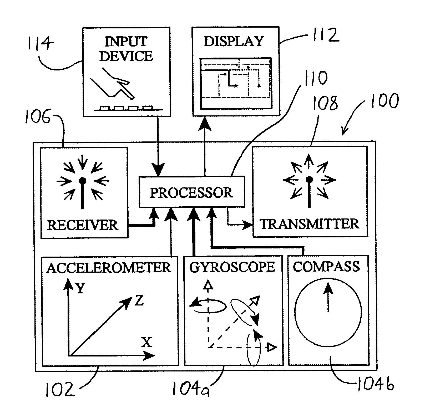
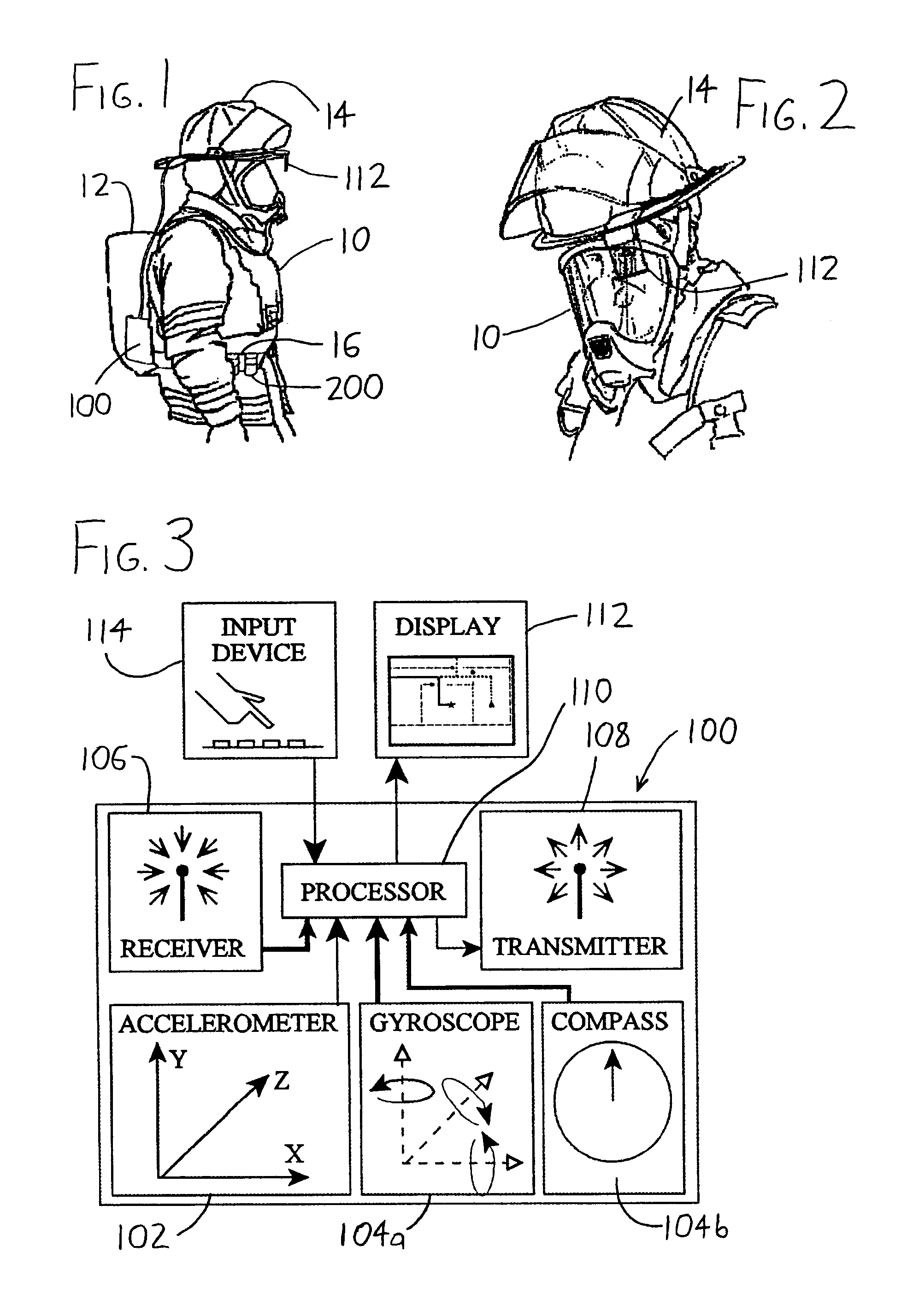
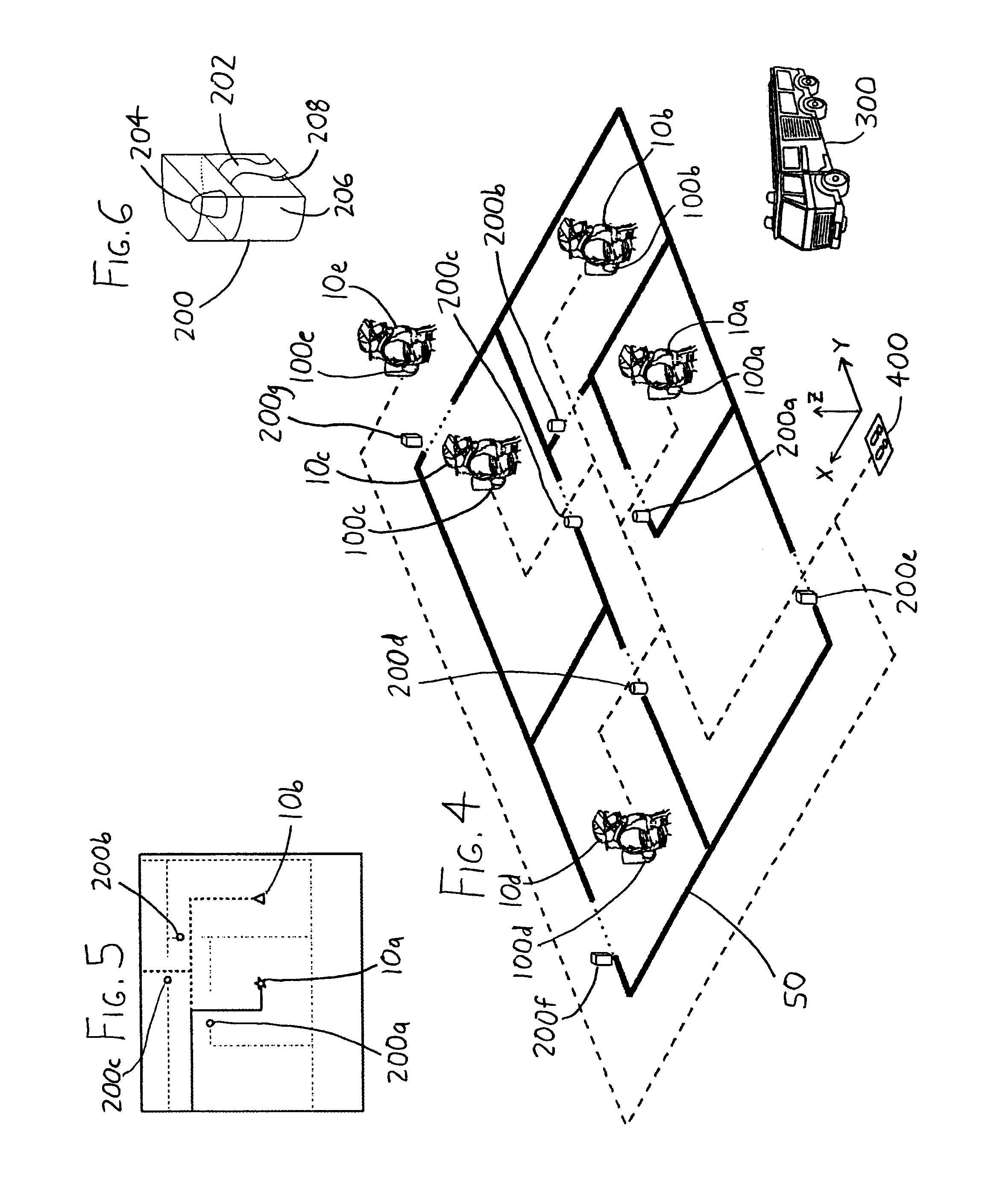
[0016]To elaborate on the foregoing discussion, the exemplary portable detection unit 100 illustrated in FIG. 3 includes an acceleration sensor 102 wherein the measured acceleration data—which is preferably measured along three orthogonal axes—is integrated over time within the processor 110 to obtain position data. Since the axes along which acceleration measurements occur within the acceleration sensor 102 will generally not remain fixed as the user moves about his / her environment, the orientation sensor 104 (i.e., gyroscope 104a and / or compass 104b) can be used to monitor the true orientations of the acceleration measurement axes so that the processor 110 can compute acceleration / position along reference axes (e.g., the XYZ axes of the acceleration sensor 102 at a reference location, such as at the initialization pad 400). As an example, with reference to FIG. 4, as a user stands on a defined location on the initialization pad 400—such as on a set of forward-facing footprints pri...


PUM


Abstract

A navigation system for navigating in low visibility environments includes a portable detection unit which uses position and orientation sensors and / or wireless location to track the position of the portable detection unit relative to some reference location, such as a fire truck. The relative position of the portable detection unit, and thus its user, is then output to a visual display for viewing by the user so that the user may see his / her position in a dark or smoky environment. The system may also include portable beacons which may be left at landmarks so that the relative positions of the landmarks may be seen on the visual display.

Description

CROSS-REFERENCE TO RELATED APPLICATIONS[0001]This application claims priority under 35 USC §119(e) to U.S. Provisional Patent Application 60 / 763,757 filed 31 Jan. 2006, the entirety of which is incorporated by reference herein.FIELD OF THE INVENTION[0002]This document concerns an invention relating generally to navigation aids for use in low-visibility environments, and more specifically to navigation aids for use by emergency response and other personnel (e.g., firefighters) in smoky, foggy, dark, or similar environments.BACKGROUND OF THE INVENTION[0003]Several occupations require personnel to work in low visibility environments. For example, firefighters often face unfamiliar environments that offer little or no visibility, as when they navigate through a burning building. When a building is on fire, smoke may obscure most or all visibility, fire sprinklers may be pouring water down from the ceiling, debris may accumulate on floors or hang from ceilings (or may disappear from floo...

Claims


Application Information

Patent Timeline
Patent Type & Authority Patents(United States)
IPC IPC(8): G08B1/08
CPCG01C21/206G01S1/70H04B5/02G08B7/066G01S5/02G01S2201/04G01S1/7038G01S1/7034G01S2205/06
Inventor NICK, MITCHELL R.NAULT, CHANDLER C.O'BRIEN, NICKTEFF, MICHAEL G.BIBA, SCOTT I.YOUNGER, CHARLES T.SCHWEITZER, CHAD
Owner FIRESITE
Why Eureka
Try Eureka