
Airborne starlight of coupling inertial position error and independent navigation method of inertial composition

An inertial combination and autonomous navigation technology, applied in the field of navigation and positioning of aviation aircraft, can solve the problems of modeling error, inability to directly realize inertial navigation error state quantity estimation, increase the complexity of system implementation, etc., and achieve the effect of improving performance

Inactive Publication Date: 2010-03-03
NANJING UNIV OF AERONAUTICS & ASTRONAUTICS
View PDF0 Cites 26 Cited by
  • Summary
  • Abstract
  • Description
  • Claims
  • Application Information

AI Technical Summary

Problems solved by technology

However, the principle of compensating the drift error of the inertial navigation gyro based on the combination of attitudes in the inertial system has the following disadvantages: ① The state equation of the system error is established in the inertial system, which can only be used for the platform error of the inertial navigation system defined in the inertial system It is impossible to directly estimate all inertial navigation error state quantities in the geographic system; ② In order to estimate the attitude combination in the inertial system, a set of inertial navigation systems independent of the geographic system must be maintained. The attitude combination algorithm increases the complexity of the system implementation; ③The linearized measurement equation between the existing attitude observation and the estimated platform error angle state quantity in the error state quantity of the aviation airborne inertial navigation system mainly adopts the Attitude error and platform error angle can be seen as an equivalence relationship or an approximate method of converting attitude measurement error into platform error angle will bring modeling error and conversion error
[0004] Therefore, the existing autonomous navigation method based on the combination of airborne starlight and inertial navigation has low navigation accuracy, and cannot fully utilize the attitude measurement equation in the geographic system to estimate the error state quantity of the airborne inertial navigation system.

Method used


Image

  • Airborne starlight of coupling inertial position error and independent navigation method of inertial composition
  • Airborne starlight of coupling inertial position error and independent navigation method of inertial composition
  • Airborne starlight of coupling inertial position error and independent navigation method of inertial composition

Examples


Embodiment Construction

[0021] Below in conjunction with accompanying drawing, the technical scheme of invention is described in detail:

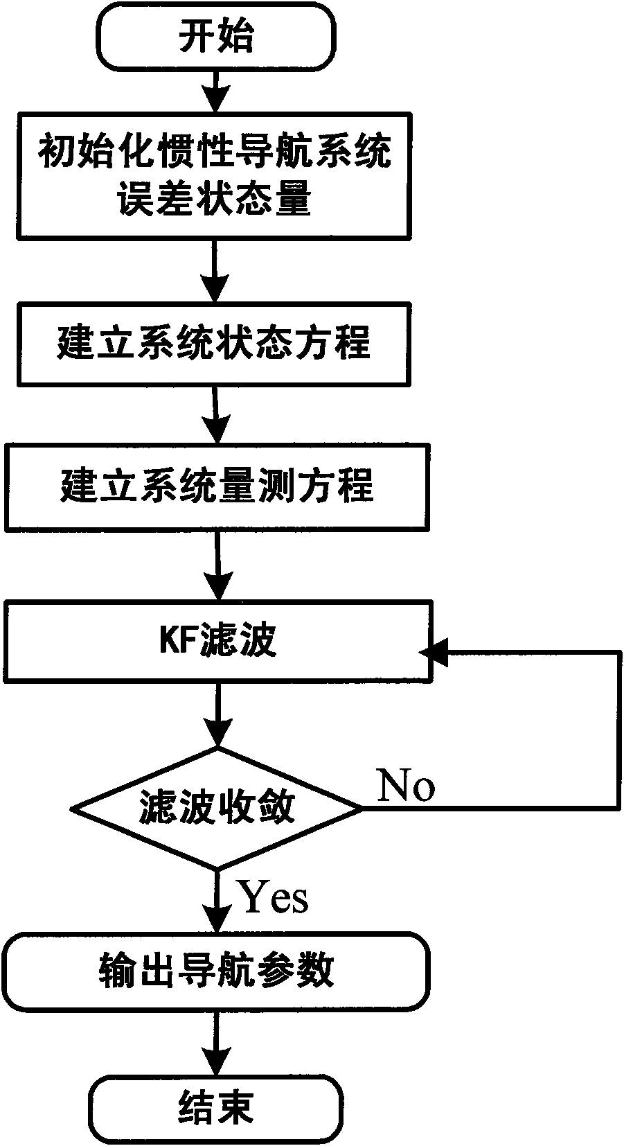
[0022] Such as figure 1 As shown, the principle of the present invention is: from the angle of navigation of the airborne geographic system, the attitude linearization measurement equation under the geographic system is established, and the interaction between the inertial attitude output by the star sensor and the attitude under the geographic system is analyzed. By transforming the relationship, the star sensor attitude linearization measurement equation coupled with the inertial navigation position error in the geographic system is established to realize the optimal estimation of the state quantity of the inertial navigation error. The specific implementation method is as follows:

[0023] 1. Establish the error state quantity equation of the aviation airborne inertial navigation system

[0024] Select the navigation coordinate system as the Northeast Heaven ...


PUM


Abstract

The invention discloses airborne starlight of a coupling inertial position error and an independent navigation method of inertial composition. In the method, firstly theoretical analysis is carried out on an attitude integrated observation principle in navigation under an aviation airborne geography department, an attitude observation linearization measurement equation under a geography departmentis established, inter-conversion relation between the attitudes from an inertial system to the geography department measured and output by a star sensor (star light) is analyzed, a coupling error model between the attitudes under the inertial system measured and output by the star sensor and the attitudes under the geography department calculated and output by the inertial navigation is established through introducing an inertial navigation position error conversion matrix, and finally aviation airborne starlight based on the modeling thoughts of the coupling inertial position error and a mathematical model of an inertial integrated navigation system are designed, and a KF filtering method is adopted to optimally estimate the error state of the inertial navigation. The invention has high-accuracy in navigation, and can give full play to the estimation function of the attitude measurement equation under the geography department on error state amount of the aviation airborne inertial navigation system.

Description

technical field [0001] The invention relates to an autonomous navigation method of airborne starlight and inertial combination coupled with inertial position error, which belongs to the technical field of integrated navigation of aviation aircraft, and can be applied to the determination of navigation parameters of aircraft flying at high altitude for a long time, and is suitable for flying at high altitude for a long time Navigation and positioning of aviation aircraft. Background technique [0002] As a high-precision astronomical attitude sensor, the star sensor is more and more widely used in the field of autonomous navigation. The star sensor can directly and accurately measure the attitude information of the aircraft relative to the inertial coordinate system without any external reference information, and its measurement accuracy remains stable throughout the navigation process. The existing highest accuracy can reach the arc-second level. [0003] At present, the ma...

Claims


Application Information

Patent Timeline
Patent Type & Authority Applications(China)
IPC IPC(8): G01C21/24
Inventor 熊智刘建业郁丰李荣冰屈蔷于永军王融陈海明高春雷
Owner NANJING UNIV OF AERONAUTICS & ASTRONAUTICS
Learn More