Optimized displaying method for dimordinate on network map

A display method and label optimization technology, which is applied in the field of geographic information systems, can solve the problems of overlapping display of label points, improve the display effect, and solve the effect of mutual covering

Inactive Publication Date: 2012-04-11
GUILIN UNIVERSITY OF TECHNOLOGY +1
View PDF2 Cites 18 Cited by
  • Summary
  • Abstract
  • Description
  • Claims
  • Application Information

AI Technical Summary

Problems solved by technology

[0003] The purpose of the present invention is to address the deficiencies of the prior art, and provide a method for marking complex and irregular geographical locations on the network map according to a specific algorithm to achieve regular arrangement and optimized display, so as to solve the overlapping display of complex mark points in the process of network map service The problem

Method used


Image

  • Optimized displaying method for dimordinate on network map
  • Optimized displaying method for dimordinate on network map
  • Optimized displaying method for dimordinate on network map

Examples


Embodiment

[0039] The invention compiles an optimization algorithm aiming at the problem of point label display under the network map environment. The research of this algorithm aims to solve the problem of overlapping display of complex label points in the map. In order to improve the network calculation speed, the number of overlapping label points in each group should be less than 10 as much as possible. In this embodiment, a small-scale area of ​​the map of areas near Guilin is selected. The specific implementation steps and program code are as follows:

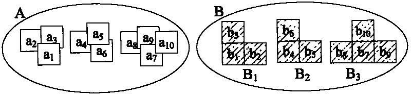
[0040] (1) Construct a dataset of labeled points:

[0041] Define the set of known label points and required label points, so that the number of known label points is equal to the number of required label points. For the set A={a 1 , a 2 , a 3 …a n} to assign the initial value, this embodiment selects 10 pairs of longitude and latitude coordinate points, and the assignment is as follows:

[0042] a 1 =(25.1742300000, 110.09780...


PUM


Abstract

The invention discloses an optimized displaying method for dimordinate on a network map, which belongs to the field of geographic information system. The positions of dimordinate on the network map are incorrect and irregular in scaling map, so that the dimordinates are irregularly distributed on the map and overlapped frequently. An optimized displaying method for dimordinate on a network map isprovided by the invention, which can automatically judge whether the dimordinates are overlapped or not and can adjust the displaying result of the dimordinates by a displacement function. Consequently, the displaying problem that the dimordinates are overlapped on the network map is solved.

Description

technical field [0001] The invention relates to a method for realizing regular arrangement and optimized display of marking points of complex and irregular geographic locations on a network map according to a set algorithm, and belongs to the field of geographic information systems. Background technique [0002] With the promotion of map services, the point labeling function has been widely used in many fields. However, during the map zooming process, due to the uncertainty and complexity of the information input of the location information of the network map annotation points, the location of the annotation points is distributed irregularly on the map, and often overlaps with each other, which affects the beauty and quality of the map. operate. Aiming at the problem of overlapping overlapping of complex label points, the current solution is to allow local label points to cover each other or to hide part of the information by weighting the importance of label point informat...

Claims


Application Information

Patent Timeline
Patent Type & Authority Applications(China)
IPC IPC(8): G06F17/30G09B29/00
Inventor 李景文孟城苏鸿苏浩李婷
Owner GUILIN UNIVERSITY OF TECHNOLOGY
Why Eureka
Try Eureka