Method for extracting forest stand vertical structure parameters on basis of airborne small-facula LiDAR (light detection and ranging) waveform data

A waveform data and vertical structure technology, applied in the direction of electromagnetic wave re-radiation, optical device, radio wave measurement system, etc., can solve the problems of difficult to describe vertical structure and low accuracy of standing vertical structure

Active Publication Date: 2012-07-04
RES INST OF FOREST RESOURCE INFORMATION TECHN CHINESE ACADEMY OF FORESTRY
View PDF4 Cites 8 Cited by
  • Summary
  • Abstract
  • Description
  • Claims
  • Application Information

AI Technical Summary

Benefits of technology

This patented technology helps better define how well an individual stands on top or underground forests from 3-dimensional (3D) scans that capture their shape. It accurately describes these structures without relying solely upon spot measurements made at specific points within them.

Problems solved by technology

This patented technical problem addressed in this patents relates to accurately extracting the shape or position from images obtained with LIDAR systems used on different types of vegetation such as conifers grown at varying ages due to environmental factors like temperature variations during growth cycles.

Method used


Image

  • Method for extracting forest stand vertical structure parameters on basis of airborne small-facula LiDAR (light detection and ranging) waveform data
  • Method for extracting forest stand vertical structure parameters on basis of airborne small-facula LiDAR (light detection and ranging) waveform data
  • Method for extracting forest stand vertical structure parameters on basis of airborne small-facula LiDAR (light detection and ranging) waveform data

Examples


Embodiment Construction

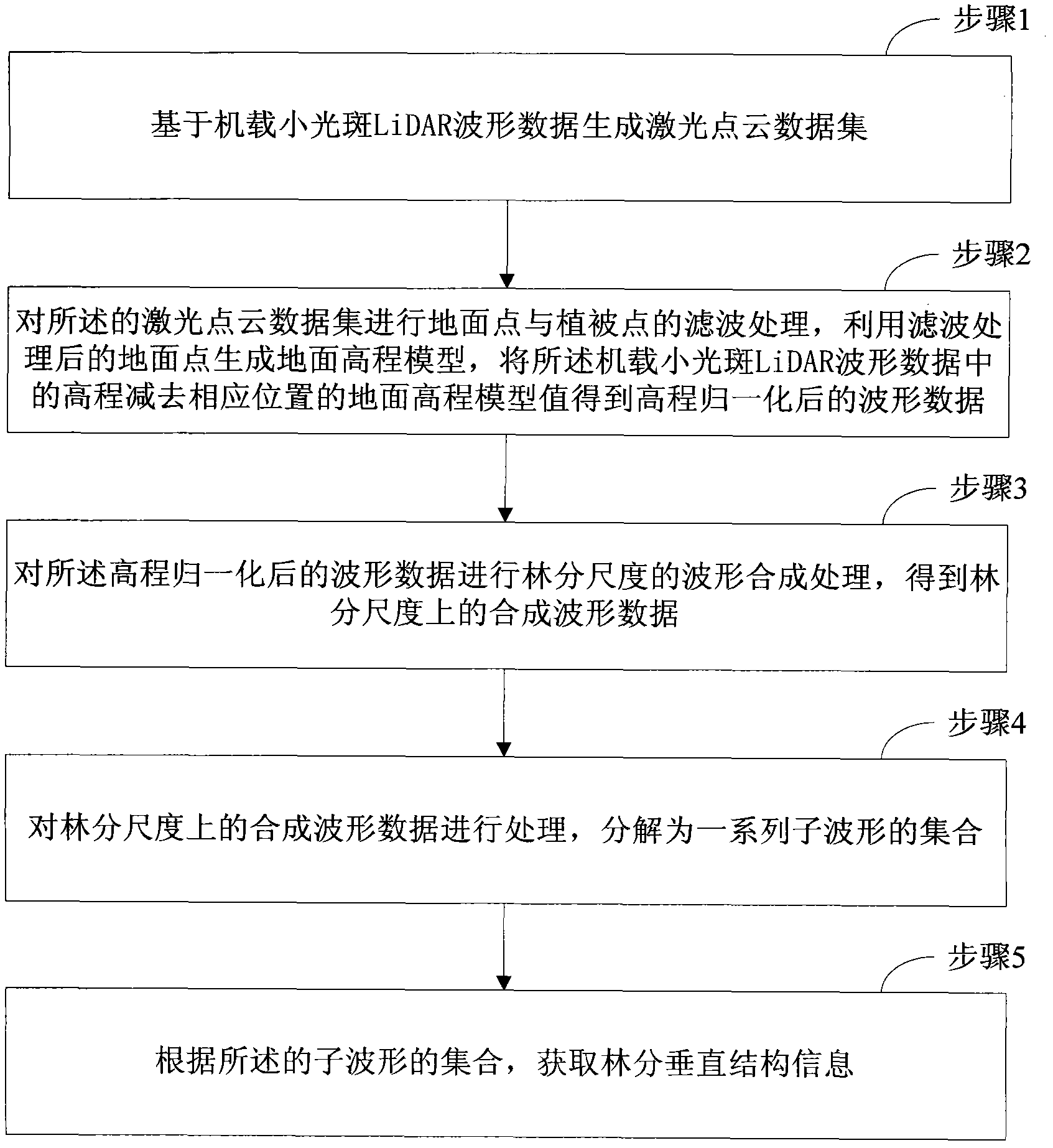
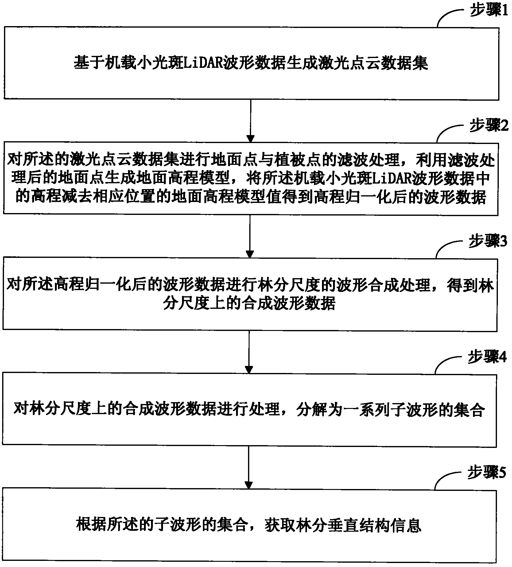
[0014] The present invention provides a method for extracting stand vertical structure parameters from airborne small-spot LiDAR waveform data, the implementation of which is as follows figure 1 As shown, it specifically includes the following operations:

[0015] Step 1. Generate a laser point cloud dataset based on the airborne small-spot LiDAR waveform data;

[0016] For the airborne small-spot LiDAR waveform data obtained during the flight, through peak detection, Gaussian decomposition or deconvolution methods, the files corresponding to each waveform data reflecting the feature points of the ground objects can be extracted. These files reflecting the feature points of the ground objects constitute the laser point cloud dataset.

[0017] Step 2, carry out the filter processing of ground point and vegetation point to described laser point cloud data set, utilize the ground point after filter processing to generate ground elevation model, subtract the elevation in the desc...


PUM


Abstract

The invention aims to provide a method for extracting forest stand vertical structure parameters on the basis of airborne small-facula LiDAR (light detection and ranging) waveform data. The method comprises the following steps of: generating a laser spot cloud data set on the basis of the airborne small-facula LiDAR waveform data; performing filtering processing on ground points and plant cover points in the laser spot cloud data set, generating a ground elevation module by using the ground points subjected to the filtering processing, and subtracting a DEM (digital elevation model) value of a corresponding position from the airborne small-facula LiDAR waveform data to obtain the waveform data after elevation normalization; performing waveform synthesis processing of the forest stand scale on the waveform data to generate synthetic waveform data of a forest stand; resolving the synthetic waveform data into a combination of a series of sub-waveforms; and acquiring the forest stand vertical structure parameters according to the combination of the sub-waveforms. According to the method provided by the invention, the depicture of a forest vertical structure is more accurate compared with that by using point cloud data, and the forest stand vertical structure parameters can be determined.

Description


Claims


Application Information

Patent Timeline
Owner RES INST OF FOREST RESOURCE INFORMATION TECHN CHINESE ACADEMY OF FORESTRY
Why Eureka
Try Eureka