Air vehicle full-parameter navigation method based on sequence image and reference image matching

A technology of sequential image and navigation method, applied in the field of full parameter measurement

Active Publication Date: 2012-12-19
NAT UNIV OF DEFENSE TECH
View PDF4 Cites 37 Cited by
  • Summary
  • Abstract
  • Description
  • Claims
  • Application Information

AI Technical Summary

Problems solved by technology

At present, the visual navigation of aircraft is mainly used for relative pose measurement and two-dimensional positioning. There is no research on visual navigati

Method used


Image

  • Air vehicle full-parameter navigation method based on sequence image and reference image matching
  • Air vehicle full-parameter navigation method based on sequence image and reference image matching
  • Air vehicle full-parameter navigation method based on sequence image and reference image matching

Examples


Embodiment Construction

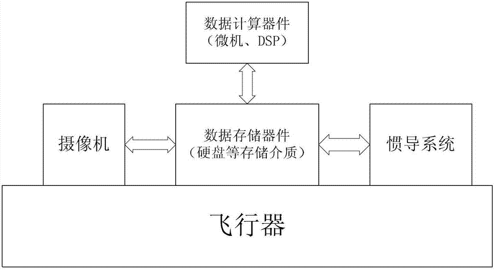
[0050] Such as figure 1 , the aircraft full-parameter navigation system based on scene matching is composed of a camera installed on the aircraft, an inertial navigation system, data processing devices (microcomputer, DSP) and storage devices (hard disk and other storage media). Among them, the camera is used for real-time imaging of the ground, the inertial navigation system is used to provide matching prediction and integrated navigation input, the data processing device is used for image matching, aircraft pose calculation and Kalman filter calculation of integrated navigation, and the storage device is used for storage Imagery and computed result data, including pre-stored datum maps with geodetic coordinates and elevations.

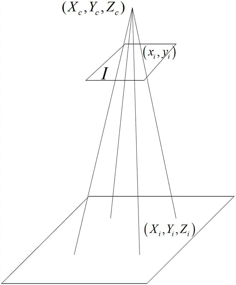
[0051] Such as figure 2 , select multiple feature points on the real-time map, match them with the reference map to obtain the three-dimensional absolute geodetic coordinates of the feature points, use the known camera internal parameters and insta...


PUM


Abstract

The invention relates to an air vehicle full-parameter navigation method based on sequence image and reference image matching. The method includes: mounting a camera, an inertial navigation system, a data processing device and a storage device on an air vehicle, and storing ground reference image data of prospective regions on a data storage device, so that an air vehicle full-parameter navigation system based on scene matching is formed. By means of sequence image and reference image matching and by the aid of Kalman filtering for integrated navigation with inertial navigation, high-precision full-parameter measurement for air vehicle navigation can be achieved, and the method has wide and important application prospect.

Description

technical field [0001] The present invention relates to the technical field of aircraft autonomous navigation and camera measurement, and further refers to the full parameter measurement of its own position, attitude, speed and attitude angular velocity by using the aircraft itself to carry a camera, an inertial navigation system and a data processing device. Background technique [0002] Aircraft navigation provides information such as real-time position and attitude for the aircraft, which is crucial to the execution of flight missions. Aircraft navigation usually requires the navigation system to provide 12 motion parameters of the aircraft in real time, including 6 zero-order quantities (three-dimensional position, attitude) and 6 primary quantities (velocity components in three directions and angular velocity components of attitude) of aircraft motion. At present, the methods that can provide full parameter measurement of the aircraft include GPS, inertial navigation, e...

Claims


Application Information

Patent Timeline
IPC IPC(8): G01C21/20G01C11/00
Inventor 于起峰雷志辉尚洋刘晓春李鑫李强李想苏昂
Owner NAT UNIV OF DEFENSE TECH
Why Eureka
Try Eureka