
Traffic information service method and system

A traffic information service, traffic information technology, applied in the direction of the arrangement of variable traffic instructions, etc., can solve problems such as difficult to distinguish, increase the difficulty of reading and understanding traffic information, affect the accuracy of route planning, and achieve the effect of avoiding manual workload

Active Publication Date: 2014-02-26
BEIJING PALMGO INFOTECH CO LTD
View PDF8 Cites 1 Cited by
  • Summary
  • Abstract
  • Description
  • Claims
  • Application Information

AI Technical Summary

Problems solved by technology

[0006] 1. The road condition information is attached to the expression of the electronic map, and it is necessary to complete the matching between the road condition information and the road section of the electronic map, which requires a large amount of manual work
[0007] 2. The road condition information is displayed in the form of a three-color transparent layer superimposed on the electronic map. In some complex road network areas, such as main and auxiliary roads, elevated / ground, overpass areas, etc., the road condition information layer and the electronic map background road network overlap each other. Intersections are difficult to distinguish, making it difficult to read traffic information; in addition, some unimportant secondary roads and branch roads are filled with road conditions, which further increases the difficulty of reading and understanding traffic information
[0008] 3. High road network coverage is an important indicator for the commercialization of road condition information. Therefore, on some low-level roads and branch roads where road condition information is difficult to effectively cover, traffic information providers will provide low-reliability road condition information based on historical data , these unreliable information will affect the accuracy of path planning
[0012] However, the illustrated road conditions can only be used for browsing the traffic conditions, and cannot be used for deeper applications, so the potential is limited

Method used


Image

  • Traffic information service method and system
  • Traffic information service method and system
  • Traffic information service method and system

Examples

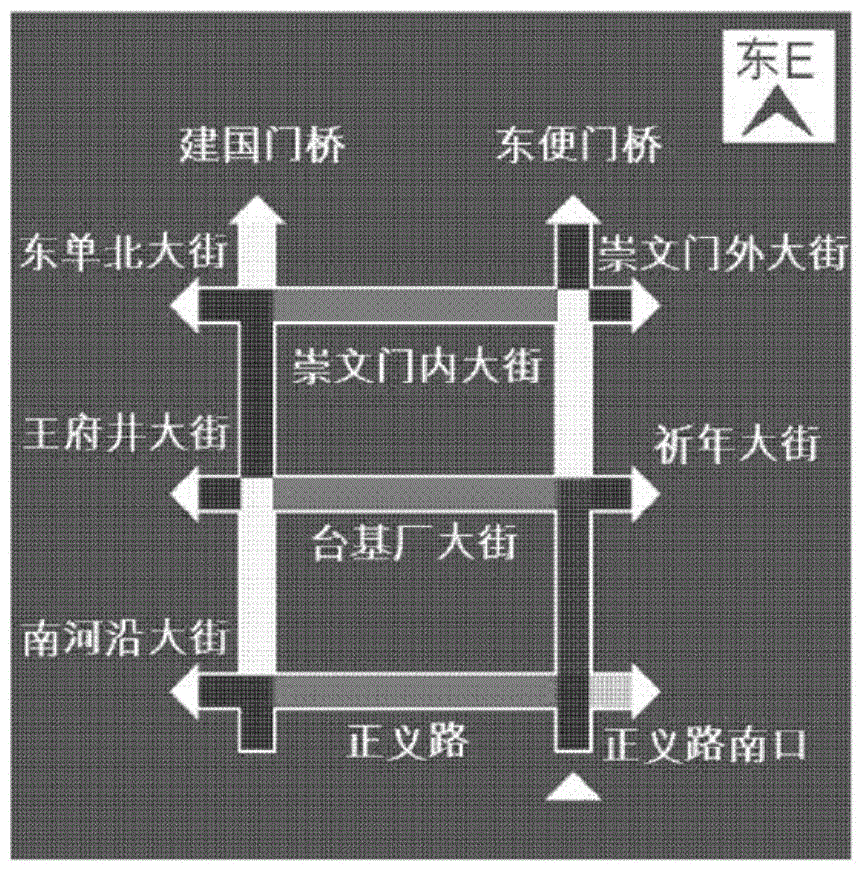
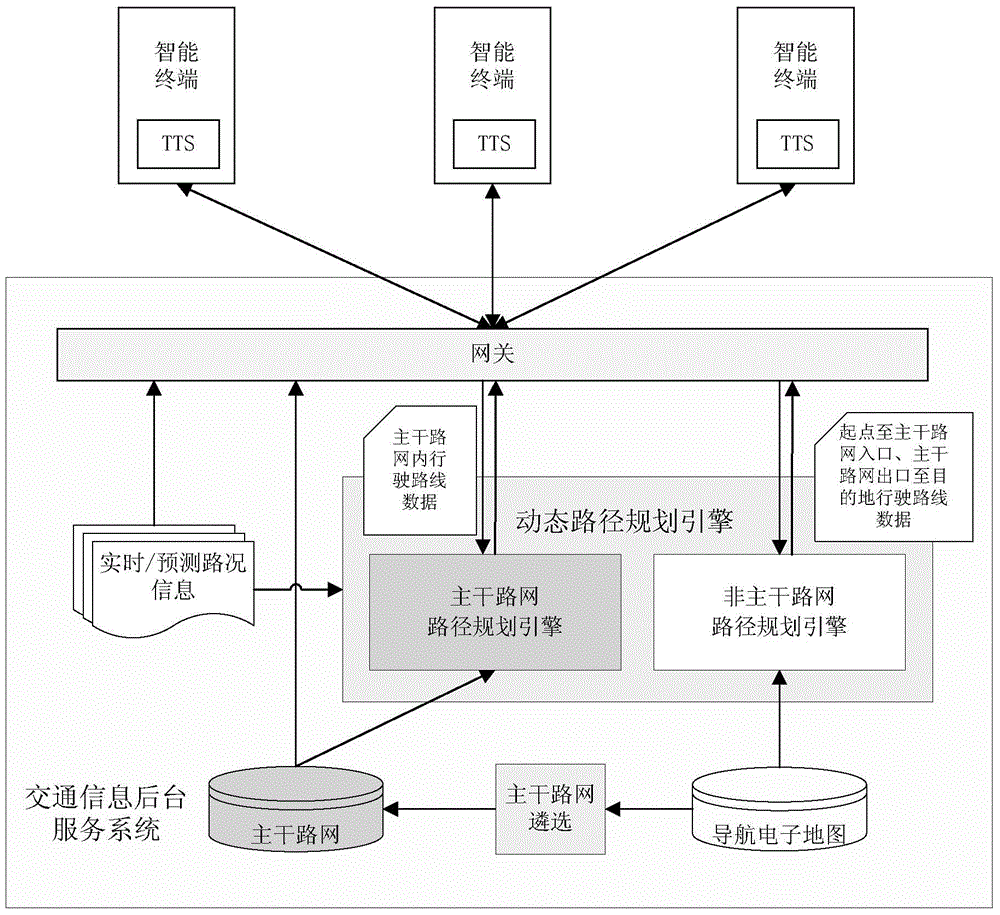

Embodiment Construction

[0027] In order to make the object, technical solution and advantages of the present invention clearer, the present invention will be further described in detail below in conjunction with the accompanying drawings.

[0028] The embodiment of the present invention proposes a method and system for realizing the expression and application of road condition information independent of electronic maps, providing abstract road condition information of the urban main road network, and providing route planning and lightweight navigation services based on road conditions on the main road network . Since it is not restricted by the expression of the electronic map, it can also provide route planning and lightweight navigation services of the backbone network, so that the road condition information can exist as an independent application form. In addition, compared with the method of overlaying and displaying traffic information and electronic maps, the method for users to obtain traffic ...


PUM


Abstract

The invention discloses a traffic information service method, and belongs to the field of intelligent transportation. The traffic information service method comprises the steps that (1) a primary road network is selected on a navigation electronic map on the basis of the road grade, and dynamic path planning is carried out on the primary road network and a secondary road network; (2) voice guiding is carried out on the primary road network on the basis of dynamic path planning information and a key guiding point; (3) if a user needs to be guided before reaching an entrance of the primary road network and after leaving an exit of the primary road network, dynamic path planning information generated before the user enters the primary road network and after the user leaves the primary road network is provided for the user in a supplementation mode. The invention further discloses a traffic information service system. The traffic information service system comprises a gateway module, a dynamic path planning engine and a primary road network generation module. Due to the fact that the traffic information service method and system achieve expression and application of road condition information in the mode of being independent from the electronic map, abstract road condition information of the urban primary road network is provided, and the path planning service and the light-weight class navigation service, on the basis of road conditions, of the primary road network are provided.

Description

technical field [0001] The invention relates to the field of intelligent traffic, in particular to a traffic information service method and system. Background technique [0002] In the face of deteriorating urban traffic conditions, dynamic traffic information, especially real-time traffic information, has increasingly penetrated and affected people's lives, providing traffic guidance and travel planning information for public travel, transportation, etc., so as to save time, reduce costs and Low-carbon environmental protection and other purposes. Among them, dynamic route planning and navigation plan the optimal driving route for users to reach the destination based on real-time road condition information (comprehensively considering route mileage, travel time, etc.), and realize TURN-BY-TURN navigation to avoid traffic congestion. The most mainstream application method of service. [0003] However, in the process of traffic information service, it is found that the publi...

Claims


Application Information

Patent Timeline
IPC IPC(8): G08G1/09
Inventor 郭胜敏于晓李平张高峰孙亚夫
Owner BEIJING PALMGO INFOTECH CO LTD
Learn More