Land use zoning method giving consideration to geographic entity semantic similarity

A semantic similarity and geographic entity technology, applied in the field of land use planning, can solve problems such as difficult zoning effects, lack of automatic implementation, and complex calculations

Active Publication Date: 2014-12-10
XINYANG NORMAL UNIVERSITY
View PDF1 Cites 15 Cited by
  • Summary
  • Abstract
  • Description
  • Claims
  • Application Information

AI Technical Summary

Problems solved by technology

[0004] However, due to the complexity of land use, the land use system is a complex system of land ecology and economy involving nature, society, and economy. Simply applying mathematical models or in

Method used


Image

  • Land use zoning method giving consideration to geographic entity semantic similarity
  • Land use zoning method giving consideration to geographic entity semantic similarity
  • Land use zoning method giving consideration to geographic entity semantic similarity

Examples


Embodiment Construction

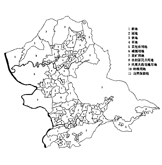
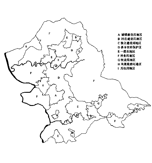
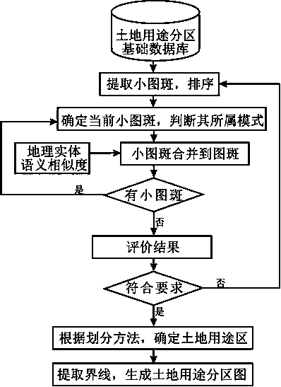
[0060] Land use zoning refers to the division of land within counties and townships (towns) into specific areas, and stipulates different land use control rules to implement control and guidance measures for land use. County-level planning can generally be divided into basic farmland protection area, general agricultural area, forestry area, animal husbandry area, urban construction area, village and town construction area, village and town construction control area, independent construction area, scenic tourism area, Eight types of land use areas in natural and cultural landscape protection areas. In the township (town) level planning, the type of the second-level area can be further determined on the basis of the above-mentioned land use area according to the local natural conditions and the needs of land use control. In principle, land use areas do not overlap with each other, and land use areas may not cover all the land within the planning range. The essence of the land ...


PUM


Abstract

The invention relates to a land use zoning method giving consideration to geographic entity semantic similarity. The land use zoning method includes inputting a basic land use zone database, iterating and extracting small picture spots and sequencing the picture spots, partitioning modes of the small picture spots and integrating in consideration of the geographic entity semantic similarity, determining land use zones according to a land use zoning method after semantic change value integrated is minimum, extracting boundary lines of the integrated picture spots and generating land use zoning pictures. Geographic entity semantic similarity is sufficiently utilized, the efficient and automatic land use zoning method is formed and scientificity, rationality and operability of land use zoning are improved.

Description

technical field [0001] The invention belongs to the field of land use planning, and in particular relates to a land use division method considering the semantic similarity of geographical entities. Background technique [0002] Land use zoning is the core issue of land use planning, and it is also the premise and key content of the optimal allocation of land use space. In practical application, land use zoning provides a basis for the regulation and management of land use. International research on land use zoning originated in Germany at the end of the 19th century, adopted by the United States in the 20th century, and later adopted in Australia, Japan, South Korea and other countries. Since the late 1990s in my country, according to the strategic needs of the country to protect cultivated land, the country is the first Then, the revision of the overall land use plan was carried out, and the land use zoning and control rules in the planning plan were proposed for the first ...

Claims


Application Information

Patent Timeline
IPC IPC(8): G06Q50/00
Inventor 牛继强徐丰姚高伟樊勇陈飞燕蚩志锋
Owner XINYANG NORMAL UNIVERSITY
Why Eureka
Try Eureka