Aerial image online splicing method capable of using synergy of CPU (central processing unit) and GPU (graphics processing unit)

A technology of aerial images and images, applied in image enhancement, image data processing, graphics and image conversion, etc.

Inactive Publication Date: 2015-01-28
CENT SOUTH UNIV
View PDF2 Cites 7 Cited by
  • Summary
  • Abstract
  • Description
  • Claims
  • Application Information

AI Technical Summary

Problems solved by technology

However, there is no technology that can achieve on

Method used


Image

  • Aerial image online splicing method capable of using synergy of CPU (central processing unit) and GPU (graphics processing unit)
  • Aerial image online splicing method capable of using synergy of CPU (central processing unit) and GPU (graphics processing unit)
  • Aerial image online splicing method capable of using synergy of CPU (central processing unit) and GPU (graphics processing unit)

Examples


Embodiment Construction

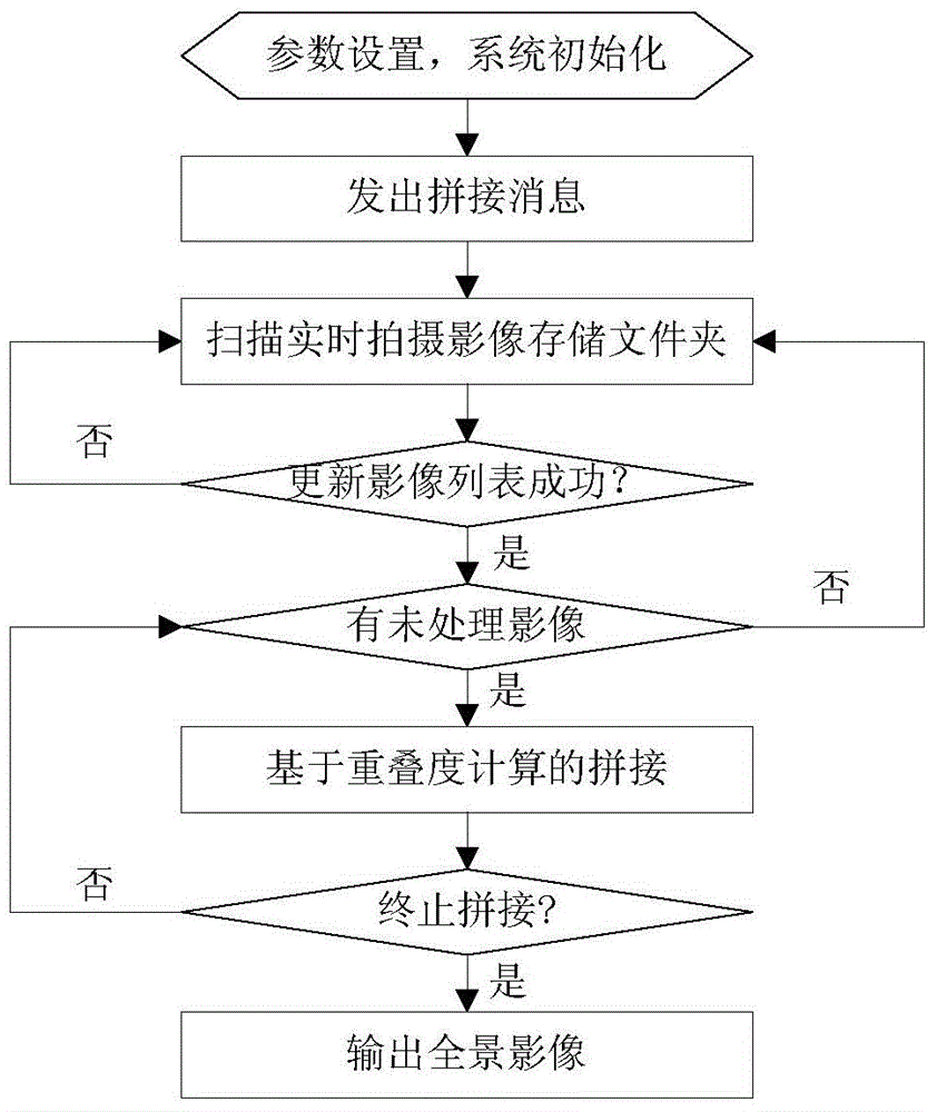
[0054] The present invention will be further described below in conjunction with the accompanying drawings and embodiments.

[0055] Such as figure 1 As shown, an online aerial image mosaic method using CPU and GPU collaboration includes the following steps:

[0056] Step 1: Initialize and set the length of the panoramic image according to the route planning map, obtain the estimated maximum length of the panoramic image, start the aerial camera, obtain the image taken by the aerial camera and the corresponding POS data, and transfer the image taken by the aerial camera The images are stored in the specified folder;

[0057] Set the focal length of the camera (in millimeters), the height of the captured image (in pixels), the width (in pixels), the height of the aircraft relative to the average horizontal plane of the ground (in meters), and the size of pixels (in microns) unit);

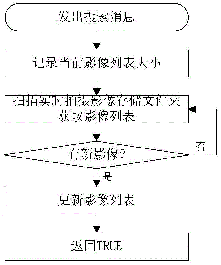
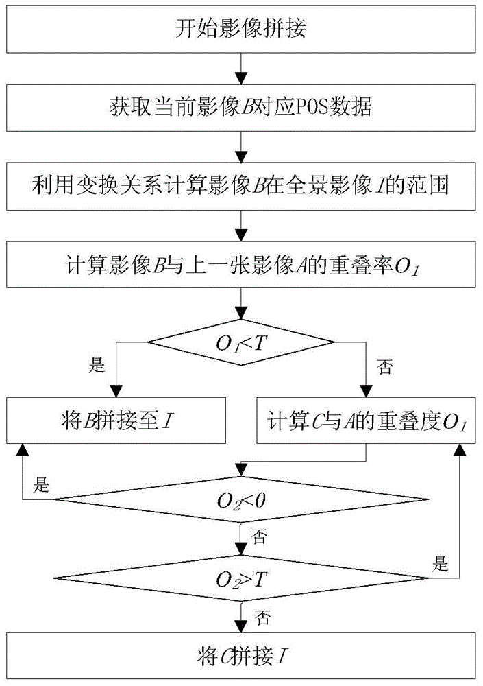
[0058] Step 2: Use the image list to record the names of the images that have been captured a...


PUM


Abstract

The invention discloses an aerial image online splicing method capable of using synergy of a CPU (central processing unit) and a GPU (graphics processing unit). The aerial image online splicing method capable of using the synergy of the CPU and the GPU includes steps: directly using POS data and an average elevation surface rectification image to replace a traditional connection point extraction and automatic vacancy three class photographic surveying process, and simultaneously using the process of calculating a homograph relationship between a current image and a corresponding rectification image at a CPU end to replace a traditional point to point numerical differentiation rectification process based on a co-linear equation, and then using GPU concurrent computation to achieve an image rectification process. Due to the fact that large overlap degrees exist among aerial images, the adaptive splicing method based on pre-computation, which is used to judge whether the current image needs to be spliced by calculating overlap degrees of following images, is used, and the amount of redundancy calculation amount is decreased to a great extent. Additionally, online real-time splicing of the aerial images is effectively achieved, and a panorama image with geographical coordinates is rapidly generated.

Description

technical field [0001] The invention relates to the technical field of aerial image processing, in particular to an online aerial image splicing method utilizing CPU and GPU cooperation. Background technique [0002] After earthquakes and other geological disasters, quickly acquiring images of disaster scenes is one of the key technologies to support emergency rescue. Aerial photogrammetry can provide intuitive, high-resolution orthophoto maps for emergency response, and can obtain high-precision information of disaster scenes, but it takes a long time to generate orthophoto maps. Therefore, it is urgent to obtain panoramic images through fast stitching. The real-time stitching of airborne images can ensure that the panoramic image stitching results can be provided immediately after the flight is completed. The panoramic image can be used as the first-hand information for disaster assessment and provide support for macro decision-making in disaster emergency response. [...

Claims


Application Information

Patent Timeline
IPC IPC(8): G06T5/50G06T3/40
Inventor 张云生邹峥嵘周培龙张明磊周行行陶超
Owner CENT SOUTH UNIV
Why Eureka
Try Eureka