Car Navition System And Method Merged Gnss With Dr

A dead reckoning and vehicle technology, which is applied in radio wave measurement systems, satellite radio beacon positioning systems, measurement devices, etc., and can solve problems such as difficulty in ensuring position accuracy, inability to correct GNSS initial position errors, and cumulative errors.

Inactive Publication Date: 2015-06-03
HYUNDAI MOBIS CO LTD
View PDF4 Cites 18 Cited by
  • Summary
  • Abstract
  • Description
  • Claims
  • Application Information

AI Technical Summary

Problems solved by technology

[0011] That is, the existing navigation system that integrates GNSS and DR works only when the accuracy of the position estimated by GNSS can be ensured, and in areas where the accuracy of GNSS position cannot be guaranteed, DR cannot correct the initial position of GNSS Errors, but also due to the accumulated errors due to the characteristics of DR itself, it is difficult to ensure the accuracy of the position

Method used


Image

  • Car Navition System And Method Merged Gnss With Dr
  • Car Navition System And Method Merged Gnss With Dr
  • Car Navition System And Method Merged Gnss With Dr

Examples


Embodiment Construction

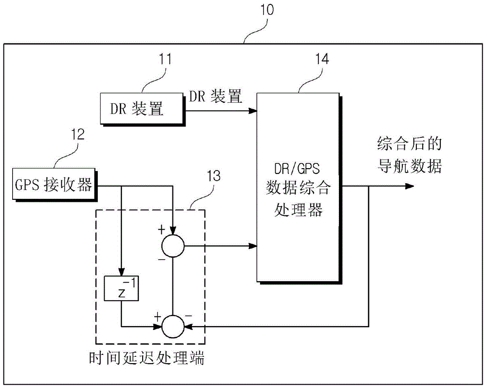
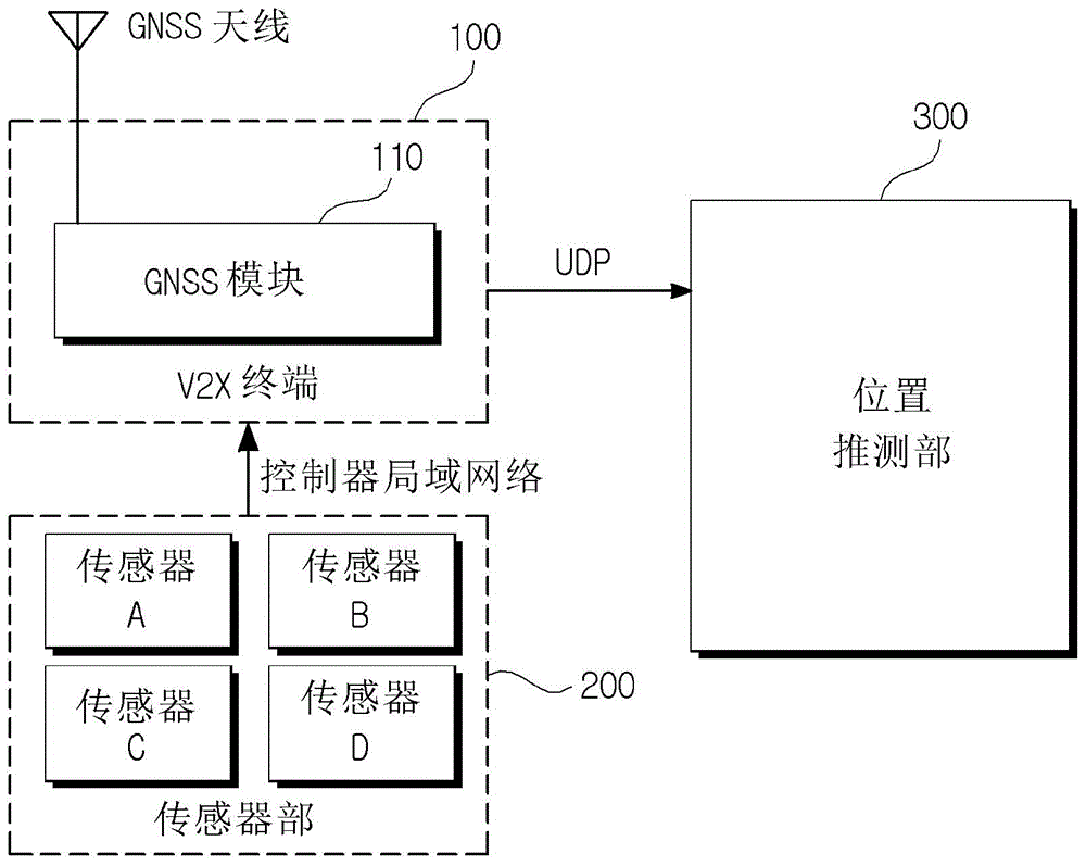
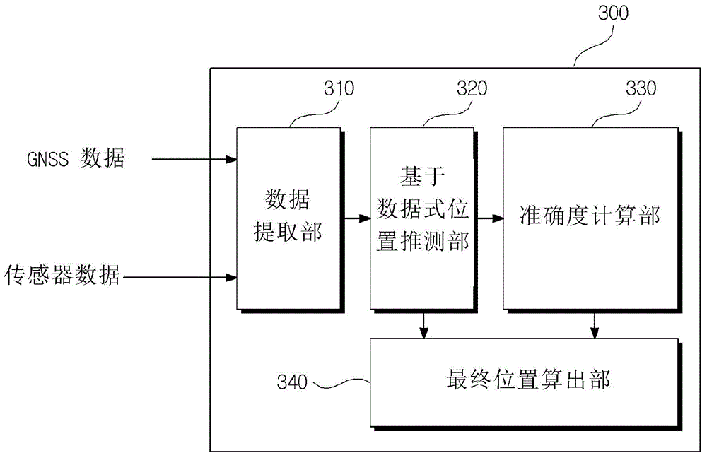
[0028] In order to fully understand the present invention, the beneficial effects of the present invention and the goals achieved by the embodiments of the present invention, it is necessary to refer to the drawings showing the preferred embodiments of the present invention and the contents recorded in the drawings.

[0029]Preferred embodiments of the present invention are described below with reference to the accompanying drawings to explain the present invention in detail. However, the present invention can be realized in various forms and is not limited to the described embodiments. In addition, in order to clearly describe the present invention, parts irrelevant to the description are omitted, and the same reference numerals in the drawings denote the same members.

[0030] When it is mentioned that a certain part "includes" a certain constituent element throughout the specification, it does not exclude other constituent elements unless there is a special contrary stateme...


PUM


Abstract

Disclosed is a car navigation system and method. The present invention includes a sensor unit including a plurality of sensors, each, configured to measure a state of a vehicle using a predetermined scheme and to obtain sensor data; a vehicle to everything (V2X) unit configured to receive the sensor data from the sensor unit, and including a global navigation satellite system (GNSS) module to thereby receive a satellite signal and to generate GNSS data; and a position estimator configured to receive the sensor data and the GNSS data from the V2X unit, to evaluate an accuracy of each of the sensor data and the GNSS data using a predetermined scheme, and to obtain position coordinates of the vehicle by merging GNSS position coordinates obtained from the GNSS data and dead reckoning (DR) position coordinates obtained from the sensor data based on the evaluation result.

Description

technical field [0001] The invention relates to a vehicle position estimation system and a method thereof, in particular to a vehicle position estimation system and a method of an integrated satellite positioning system and dead reckoning method. Background technique [0002] For a navigation system that provides position information and route information for moving objects such as aircraft, ships, and vehicles, and guides the moving objects to their destinations, the most important thing is to determine the exact location of the moving objects. [0003] Most of the current navigation systems basically adopt the Global Navigation Satellite System (Global Navigation Satellite System: hereinafter referred to as GNSS) which tracks the accurate position of ground objects through artificial satellite networks. GNSS uses the Global Positioning System (Global Positioning System: hereinafter referred to as GPS) of the United States, the Global Navigation Satellite System (hereinafte...

Claims


Application Information

Patent Timeline
Patent Type & Authority Applications(China)
IPC IPC(8): G01S19/42
CPCG01C21/12G01S19/45G01S19/47G01S19/49G01C21/188
Inventor 具本彧李商善金浚成李东键
Owner HYUNDAI MOBIS CO LTD
Why Eureka
Try Eureka