Ship trajectory mining, analysis and monitoring method based on specific region

A technology of ship trajectory and specific area, applied in the field of ship trajectory mining analysis and monitoring based on specific area, can solve the problem of not taking into account the overall shape of the space target, and achieve the effect that the clustering results are universal and the clustering results are better.

Active Publication Date: 2015-09-09
HUAZHONG NORMAL UNIV
View PDF3 Cites 56 Cited by
  • Summary
  • Abstract
  • Description
  • Claims
  • Application Information

AI Technical Summary

Benefits of technology

This patented technology allows for flexible customization of analyzed areas while maintaining consistence across different parts of an overall map. It achieves this by dividing large sections into smaller ones called tracklets where each section contains only one point instead of all them together. These small tracks help identify movement patterns along their way from any location they happen at once. Overall, it improves efficiency and accuracy in finding ships' movements over time.

Problems solved by technology

This patents discusses various techniques that can help identify important parts or features from sea track movements (mobility) on board vessels during navigation operations. These include identifying key areas related to vessel dynamics, predicting future boat motions based on their past performance over space, studying the temporal changes caused by these factors like wake waves, ocean currents, etc., finding ways to improve understanding cruise behavior through situational awareness systems, providing technical means to enhance marine navigations capabilities.

Method used


Image

  • Ship trajectory mining, analysis and monitoring method based on specific region
  • Ship trajectory mining, analysis and monitoring method based on specific region

Examples


Embodiment Construction

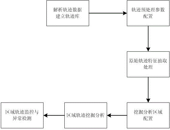
[0043] The implementation of the present invention adopts the PostgreSQL open source database supporting geospatial data storage and operation and the front-end open source Web GIS development library package OpenLayers supporting Ajax, covering the trajectory data processing subsystem, the ship information query subsystem, the trajectory analysis monitoring subsystem and Background configuration management subsystem. Such as figure 2 As shown, the specific implementation steps of the method of the present invention are as follows:

[0044] Step 1. Analyze the trajectory data and establish a trajectory database.

[0045] According to the position report message sent by the AIS system, the AIS track data is analyzed and stored in the ship information table and the original AIS information table.

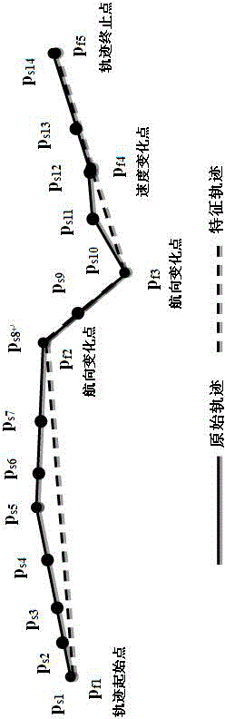
[0046] Step 2, trajectory data preprocessing parameter configuration, including setting the speed change rate and heading change rate threshold, here are both set to 10%.

[0047] Step ...


PUM


Abstract

The present invention relates to the field of ship trajectory mining, analysis and monitoring in ocean transportation, and provides a ship trajectory mining, analysis and monitoring method based on a specific region. The method comprises: mining, clustering and analyzing trajectories of ships in a specific region, extracting a ship mode trajectory in the specific region, and using the ship mode trajectory as an important reference for monitoring and anomaly analysis on the ships in the specific region, thereby implementing regional monitoring and anomaly analysis on the ships.

Description


Claims


Application Information

Patent Timeline
Owner HUAZHONG NORMAL UNIV
Why Eureka
Try Eureka