Target road matching method through vehicle positioning information and system thereof

A technology of information matching and vehicle positioning, which is applied to road vehicle traffic control systems, traffic control systems, instruments, etc., and can solve problems such as inability to locate information matching roads, large amount of real-time positioning data, etc.

Active Publication Date: 2016-06-22
中交信捷科技有限公司
View PDF6 Cites 14 Cited by
  • Summary
  • Abstract
  • Description
  • Claims
  • Application Information

AI Technical Summary

Problems solved by technology

[0002] In the GNSS monitoring system of large-scale road transport vehicles, there are many online vehicles, and the real-time positioning data received by the GNSS monitoring system is huge.

Method used


Image

  • Target road matching method through vehicle positioning information and system thereof
  • Target road matching method through vehicle positioning information and system thereof
  • Target road matching method through vehicle positioning information and system thereof

Examples


Embodiment Construction

[0075] The following will clearly and completely describe the technical solutions in the embodiments of the present invention with reference to the accompanying drawings in the embodiments of the present invention. Obviously, the described embodiments are only some, not all, embodiments of the present invention. Based on the embodiments of the present invention, all other embodiments obtained by persons of ordinary skill in the art without making creative efforts belong to the protection scope of the present invention.

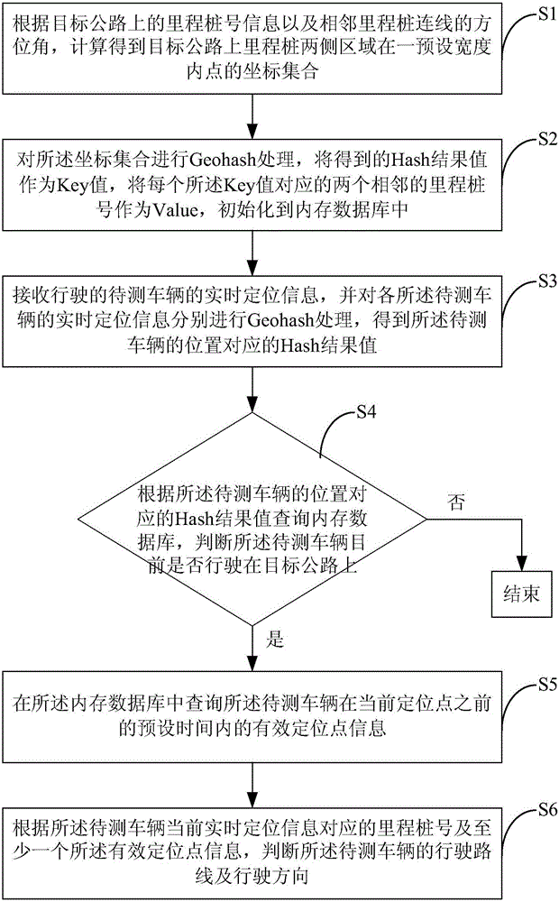
[0076] figure 1 It is a schematic flowchart of a method for matching target roads with vehicle positioning information according to an embodiment of the present invention. Such as figure 1 As shown, the method mainly includes the following steps:

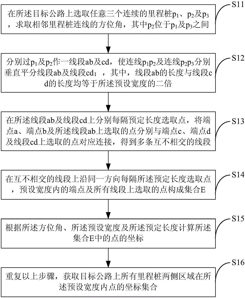
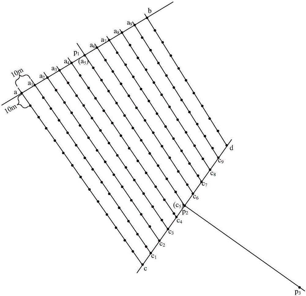
[0077] Step S1. Collect the coordinate data of the mileage stake number of the target highway line, and calculate the points on both sides of the mileage stake on the target road within a preset width according to...


PUM


Abstract

The invention provides a target road matching method through vehicle positioning information and a system thereof. The method comprises the steps that a coordinate collection of points within preset width of areas of the two sides of mileage pegs on a target road is calculated according to mileage peg number information of the target road and the azimuth of the connecting line of the adjacent mileage pegs; Geohash processing is performed on the coordinate collection, obtained Hash result values act as Key values, and two adjacent mileage peg numbers corresponding to each Key value act as Value; Geohash processing is performed on real-time positioning information of a vehicle to be tested so that a corresponding Hash result value is obtained; a memory database is inquired according to the Hash result value corresponding to the positioning information of the vehicle to be tested and whether the vehicle to be tested is currently driven on the target road is judged; when the vehicle to be tested is driven on the target road, effective positioning point information of the vehicle to be tested within preset time before the current positioning point is inquired; and the driving route and direction of the vehicle to be tested are judged according to the mileage peg numbers corresponding the current real-time positioning information of the vehicle to be tested and the information of at least one effective positioning point.

Description

technical field [0001] The invention relates to a method and a system for matching vehicle driving roads with vehicle positioning information acquired by a global navigation satellite system (Global Navigation Satellite System, GNSS). Background technique [0002] In the GNSS monitoring system of large-scale road transport vehicles, there are many online vehicles, and the real-time positioning data received by the GNSS monitoring system is huge. It is difficult to analyze and process these data in a timely manner, and it is impossible to match the road on which the vehicle is driving based on the positioning information of the vehicle. . [0003] The road transport vehicles involved in the present invention refer to the road transport vehicles referred to in the "Measures for the Dynamic Supervision and Administration of Road Transport Vehicles" (Order No. 5, 2014), including passenger vehicles for road operations, dangerous goods transport vehicles, and semi-trailer tractor...

Claims


Application Information

Patent Timeline
IPC IPC(8): G08G1/127
CPCG08G1/127
Inventor 张一衡沈刚王建江李祥李杰李凯
Owner 中交信捷科技有限公司
Why Eureka
Try Eureka