3D Map Modeling Surface Contour Fast Linkage Rendering Method

A three-dimensional map and surface technology, applied in the field of three-dimensional maps, can solve the problems of spending a lot of time and energy, not being able to guarantee the patch shooting point, a large amount of economic cost and time cycle, etc., to improve work efficiency, avoid image stitching errors, shorten The effect of the duty cycle

Active Publication Date: 2019-08-02
上海网罗电子科技有限公司
View PDF2 Cites 0 Cited by
  • Summary
  • Abstract
  • Description
  • Claims
  • Application Information

AI Technical Summary

Problems solved by technology

[0004] At present, it is proposed to use drones to build real-time 3D maps, and to extract and analyze information through environmental perception, so as to realize positioning and 3D map construction. In the case of uncertain positions, it has certain application value, but it needs continuous judgment It takes a lot of time and energy to select a new picture shooting point, and it is impossible to guarantee the best patch shooting point; in addition, it is proposed to obtain a two-dimensional map texture generated by two-dimensional vector map data and digital elevation data, and generate a belt texture after processing. The three-dimensional map of the texture improves the efficiency and speed in the patching process, but it still needs to be photographed manually in the early stage of image acquisition, which requires a lot of economic cost and time period, etc.

Method used


Image

  • 3D Map Modeling Surface Contour Fast Linkage Rendering Method
  • 3D Map Modeling Surface Contour Fast Linkage Rendering Method

Examples


Embodiment Construction

[0023] Specific embodiments of the present invention will be described in detail below in conjunction with specific drawings. It should be noted that the technical features or combinations of technical features described in the following embodiments should not be regarded as isolated, and they can be combined with each other to achieve better technical effects. In the drawings of the following embodiments, the same reference numerals appearing in each drawing represent the same features or components, which can be applied in different embodiments.

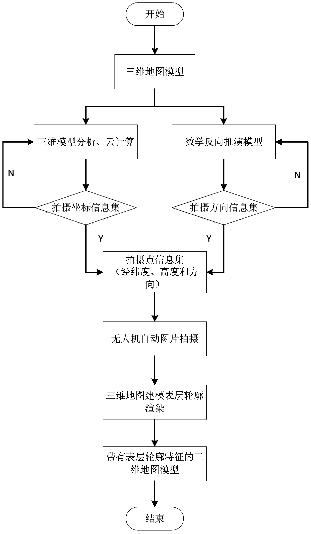
[0024] According to an embodiment of the present invention, a fast linkage rendering method of a three-dimensional map modeling surface contour includes the following steps:

[0025] Step 1, on the basis of obtaining the coordinate information of the building, construct the structural layout diagram of each floor of the building, and establish a three-dimensional map model of the building;

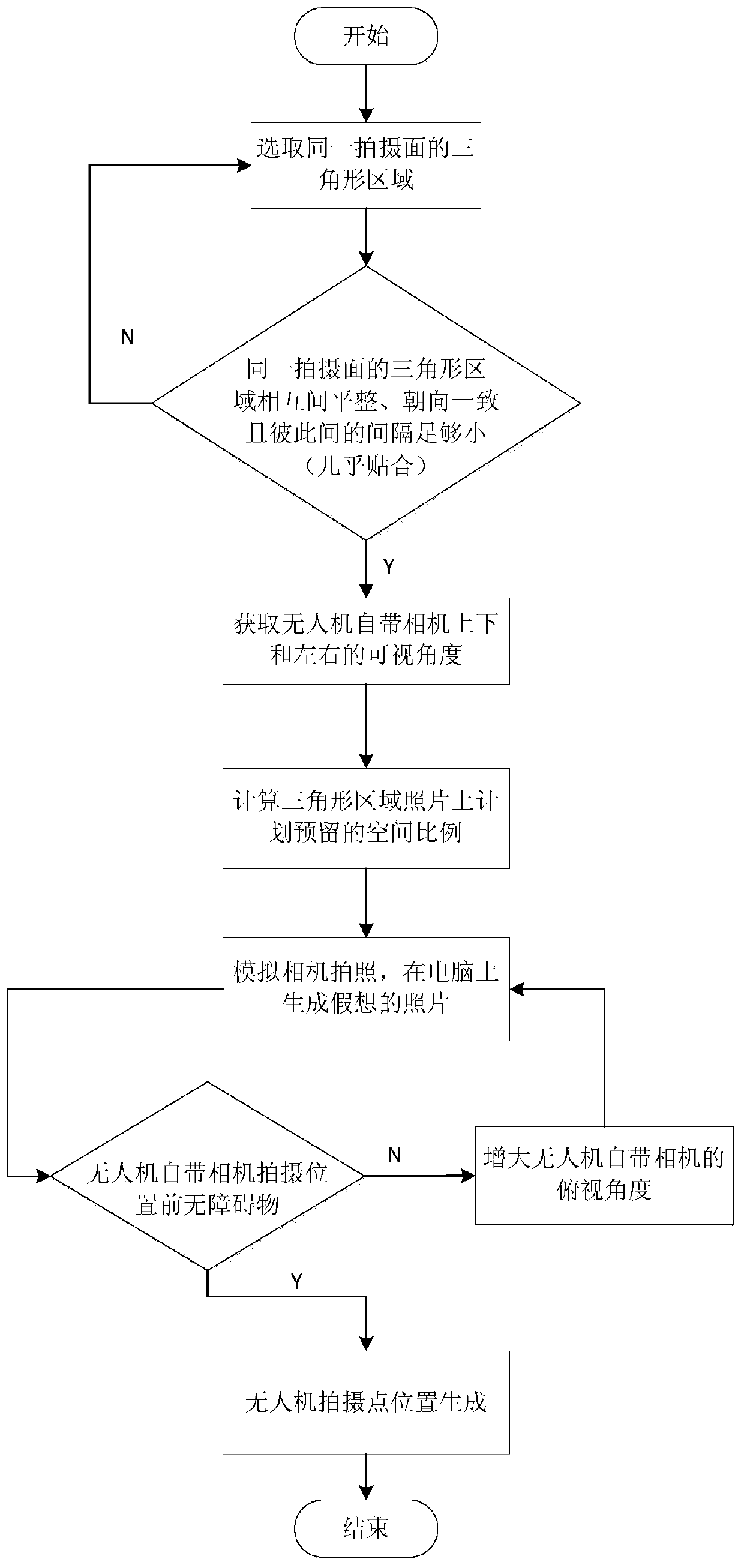
[0026] Step 2, analyze the characterist...


PUM


Abstract

The invention relates to the technical field of 3D map, and provides a 3D map modeling surface contour fast linkage rendering method. The method comprises the following steps: (1) acquiring the coordinate information of a building, and building a 3D map model; (2) analyzing the characteristics of a surface mounting area, and determining the space coordinates of shooting points of an unmanned aerial vehicle in batches according to a mathematical reverse deduction model; (3) storing the space coordinates of the shooting points; inputting the space coordinates of the shooting points of the unmanned aerial vehicle to the unmanned aerial vehicle to realize automatic shooting by the unmanned aerial vehicle; and (5) automatically screening a shot image to match the surface mounting area according to the feature point information of the surface mounting area, and performing surface mounting. The beneficial effects are as follows: with the help of 3D map modeling, cloud computing, a mathematical reverse deduction model, an unmanned aerial vehicle and a smart surface mounting technology, efficient linked 3D modeling surface rendering is realized, and the surface texture characteristics of a 3D map are presented truly; the shooting points of an unmanned aerial vehicle are automatically generated in batches, position deviation caused by artificial selection is avoided, the work continuity is improved while the quality of rendered images is guaranteed, and manpower and material resources are saved.

Description

technical field [0001] The invention relates to the technical field of three-dimensional maps, in particular to a fast linkage rendering method for three-dimensional map modeling surface contours. Background technique [0002] At present, with the acceleration of urbanization, urban development is changing with each passing day. The integration of information industrialization has made the integration of urban information an inevitable trend, and the construction of "digital city" has been pushed to the national strategic level, in which the establishment of three-dimensional electronic maps of cities plays an increasingly important role. The 3D map gives users an intuitive real-time display, provides convenience for users' travel map query and navigation guidance, and at the same time provides humanized services in e-commerce, daily information, publicity and interaction, etc., truly builds a city information system, and realizes "digital city" national strategic goals. ...

Claims


Application Information

Patent Timeline
Patent Type & Authority Patents(China)
IPC IPC(8): G06T15/00G06T15/04G06T17/05
CPCG06T15/005G06T15/04G06T17/05
Inventor 李娜
Owner 上海网罗电子科技有限公司
Why Eureka
Try Eureka