Solar-altitude-based self-adapting high orbit area-array camera in orbit geometrical calibration method

A technology of solar elevation angle and area array camera, which is applied to satellite radio beacon positioning systems, measuring devices, instruments, etc., can solve the problems of less research, changes in satellite geometric imaging parameters, and the inability of calibration values ​​to meet high-precision geometric processing. , to achieve the effect of ensuring internal geometric accuracy and external positioning accuracy

Active Publication Date: 2017-06-20
CHINA CENT FOR RESOURCES SATELLITE DATA & APPL
View PDF5 Cites 11 Cited by
  • Summary
  • Abstract
  • Description
  • Claims
  • Application Information

AI Technical Summary

Problems solved by technology

Although the satellite will undergo strict laboratory calibration before launch, due to factors such as vibration during launch, material outgassing, changes in imaging conditions during in-orbit operation, and aging of devices, the geometric imaging parameters of the satellite will change. The calibration value on the ground cannot meet the needs of high-precision geometric processing, so it is necessary to perform on-orbit calibration on the satellite
[0003] At present, a lot of research and practical work have been carried out on the geometric calibration of close-range cameras, aerial cameras, optical linear array push-broom satellites, and joint geometric calibration of multi-linear optical push-broom satellites. Except for meteorological satellites with kilometer-level resolution, high-orbit satellites do not have high-orbit area array cameras with a resolution of hundreds of meters. Therefore, there are few studies on the on-orbit geometric calibration of high-orbit area array cameras, and a mature system has not yet been formed. Theory and Method

Method used


Image

  • Solar-altitude-based self-adapting high orbit area-array camera in orbit geometrical calibration method
  • Solar-altitude-based self-adapting high orbit area-array camera in orbit geometrical calibration method
  • Solar-altitude-based self-adapting high orbit area-array camera in orbit geometrical calibration method

Examples


Embodiment Construction

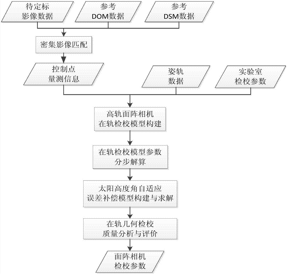
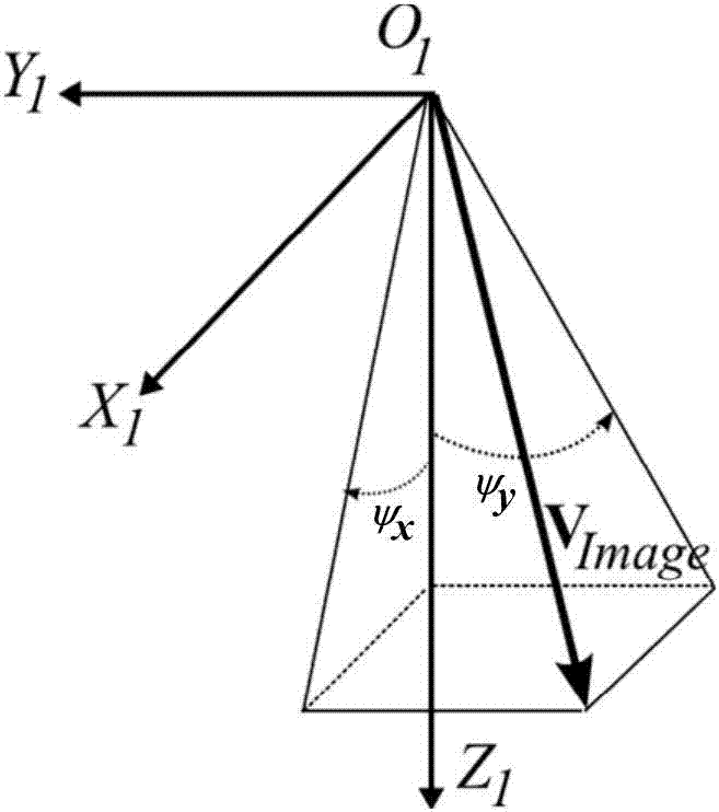
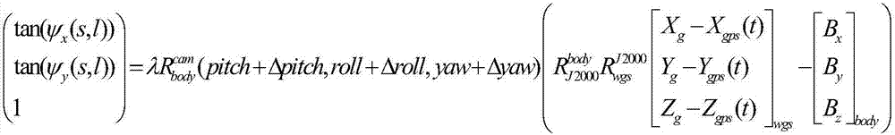
[0033] The present invention will be described in detail below in conjunction with the accompanying drawings and examples. like figure 1As shown, the on-orbit geometric calibration method of the high-orbit area array camera based on the self-adaptation of the sun altitude angle is characterized in that it includes the following steps:

[0034] Step 1. From the control points in the control point database, the control points are automatically measured on the image to be calibrated to obtain the control point measurement information; in order to ensure the calculation accuracy of the on-orbit geometric calibration results, the measured control points are Suggestions are provided in terms of quantity and distribution: in the image to be calibrated, the measured control points should cover the entire CCD range evenly in the along-track direction and the vertical track direction, and should be evenly distributed in the image to be calibrated, within each area The number of control...


PUM


Abstract

The invention relates to a solar-altitude-based self-adapting high orbit area-array camera in orbit geometrical calibration method. The solar-altitude-based self-adapting high orbit area-array camera in orbit geometrical calibration method includes the steps: 1) selecting a control point in a control point database, performing automatic measuring of the control point on an image to be calibrated, and acquiring the measuring information of the control point, wherein selection of control point satisfies the condition that at least one control point exists in the 10*10 grid range; 2) constructing an in orbit calibration geometrical model, based on a two-dimensional cubic surface detector directional angle, of a high orbit area-array camera; 3) utilizing the control point information automatically measured in the step 1, utilizing a step-by-step and grading iterative solution strategy to solve the in orbit calibration geometrical model parameter of the two-dimensional cubic surface detector directional angle in the step 2; 4) constructing a solar altitude self-adapting error compensation model and performing parametric solution in different latitude and longitude areas, at different imaging times and at different solar altitudes; and 5) taking the in orbit calibration geometrical model parameter and the solar altitude self-adapting error compensation model parameter as the final strict imaging model construction parameters to reproduce the calibration image and calibrate the internal and external precision of the reproduced image.

Description

technical field [0001] The invention belongs to the field of on-orbit geometric calibration and processing of remote sensing images, and relates to a high-precision on-orbit geometric calibration method for high-orbit area array cameras based on solar elevation angle self-adaptation. Background technique [0002] On-orbit geometric calibration of satellites is a key link for optical remote sensing satellites to achieve high-precision geometric positioning, which directly affects the internal and external geometric accuracy of satellite images. Although the satellite will undergo strict laboratory calibration before launch, due to factors such as vibration during launch, material outgassing, changes in imaging conditions during in-orbit operation, and aging of devices, the geometric imaging parameters of the satellite will change. The calibration values ​​on the ground cannot meet the needs of high-precision geometric processing, so it is necessary to perform on-orbit calibra...

Claims


Application Information

Patent Timeline
Patent Type & Authority Applications(China)
IPC IPC(8): G01S19/23
CPCG01S19/235
Inventor 王冰冰李庆鹏龙小祥程宇峰喻文勇秦敬芳李晓进
Owner CHINA CENT FOR RESOURCES SATELLITE DATA & APPL
Why Eureka
Try Eureka