GNSS measurement control network precision estimation method

A technology of measurement control and control network, applied in the direction of measurement devices, radio wave measurement systems, satellite radio beacon positioning systems, etc., can solve the problem that the estimation method cannot take into account the control network receiving conditions, and the precision estimation index is not consistent with the actual situation. Comply with, do not consider the station occlusion conditions and other issues

Active Publication Date: 2017-07-18
POWERCHINA XIBEI ENG
View PDF7 Cites 12 Cited by
  • Summary
  • Abstract
  • Description
  • Claims
  • Application Information

AI Technical Summary

Problems solved by technology

[0004] The purpose of the present invention is to provide a method for estimating the accuracy of a GNSS measurement control network, which solves the problem that the existing estimation method cannot take into account the actual receiving conditions of the control network, and solves the problem that the existing estimation method does not consider the occlusion condition of the station, resulting in a high accuracy. The problem that the estimated indicators do not match the actual situation

Method used


Image

  • GNSS measurement control network precision estimation method
  • GNSS measurement control network precision estimation method
  • GNSS measurement control network precision estimation method

Examples


Embodiment Construction

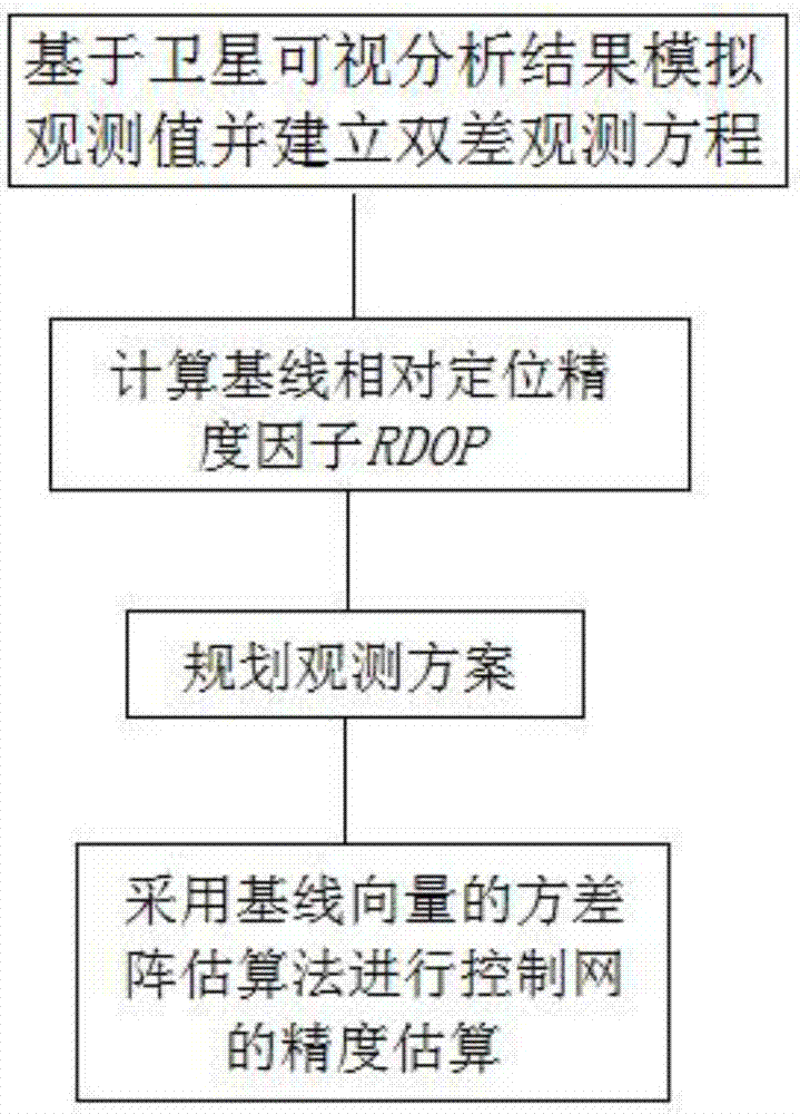
[0064] The present invention will be described in further detail below in conjunction with the accompanying drawings and specific embodiments, but the present invention is not limited to the following specific embodiments.

[0065] The estimation method of GNSS measurement control network precision of the present invention, refer to figure 1 , specifically follow the steps below:

[0066] Step 1, Satellite Visibility Analysis

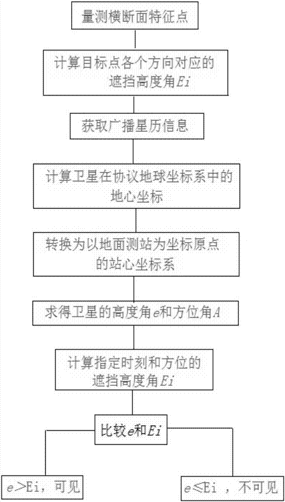
[0067] The determination method of ephemeris forecast taking into account satellite occlusion conditions refers to figure 2 .

[0068] (1) Measure the satellite occlusion altitude angle of the target point;

[0069] Based on topographic maps, digital elevation models (DEM) or other digital geographic information products with elevation attributes, the elevation angle of a single station satellite is measured.

[0070] First determine the coordinates of the target point, and then measure the cross-section clockwise from the north direction at a cert...


PUM


Abstract

The invention discloses a GNSS measurement control network precision estimation method. The method comprises the following steps of 1, based on a satellite shielding boundary constraint condition, carrying out visible baseline satellite analysis, based on an analysis result, simulating each observation station observation value, establishing a double-difference observation equation and solving, and according to a Q diagonal matrix in an error equation, calculating a relative positioning precision factor of a baseline; 2, carrying out synchronization observation combination screening of target observation points, calculating each baseline DOP value condition of different observation periods, and according to a screened constructed network condition and a precision factor corresponding to the observation period, carrying out synchronization ring observation precision estimation which is used for selection of a synchronization observation point position and the observation periods; and 3, according to a plurality of synchronization rings, carrying out networking, and using a variance matrix estimation method of a baseline vector to estimate precision mi of a control network. The method is suitable for carrying out GNSS observation in difficult areas of a high-mountain and valley area, an area possessing a urban building effect and the like, a precision index is reliable.

Description

technical field [0001] The invention belongs to the technical field of GNSS measurement control network measurement, and in particular relates to a method for estimating the precision of a GNSS measurement control network. Background technique [0002] At present, the most common method for estimating the accuracy of GNSS survey control network is the simulation method, which needs to simulate the observed value through the approximate coordinates of the control network points, and simulate the covariance of the observed value, and select a suitable accuracy estimation model. This method is implemented in detail A variety of methods were derived in the process, but no matter the simulation method or other estimation methods, they did not take into account the boundary constraints of the actual satellite signal ground obstructions at each control point, nor did they take into account the shared satellite situation of the baseline. There is a certain difference between the acc...

Claims


Application Information

Patent Timeline
Patent Type & Authority Applications(China)
IPC IPC(8): G01S19/20G01S19/27
CPCG01S19/20G01S19/27
Inventor 李祖锋万宗礼薛绍军吕宝雄缪志选
Owner POWERCHINA XIBEI ENG
Why Eureka
Try Eureka