A route planning method for water diversion works in high-altitude mountainous areas

A water diversion project and high-altitude technology, used in data processing applications, forecasting, instruments, etc., can solve the problems of time-consuming and ill-considered manual planning.

Active Publication Date: 2020-06-16
HOHAI UNIV
View PDF2 Cites 0 Cited by
  • Summary
  • Abstract
  • Description
  • Claims
  • Application Information

AI Technical Summary

Problems solved by technology

[0004] The technical problem to be solved by the present invention is to provide a method for planning a water diversion project line in a high-altitude mountain area, which can make up for the time-consuming, laborious, and ill-considered defects of the manual planning of a water diversion project line, and can effectively improve the work efficiency and reliability of water diversion project planning

Method used


Image

  • A route planning method for water diversion works in high-altitude mountainous areas
  • A route planning method for water diversion works in high-altitude mountainous areas
  • A route planning method for water diversion works in high-altitude mountainous areas

Examples


Embodiment Construction

[0076] The specific implementation manners of the present invention will be further described in detail below in conjunction with the accompanying drawings.

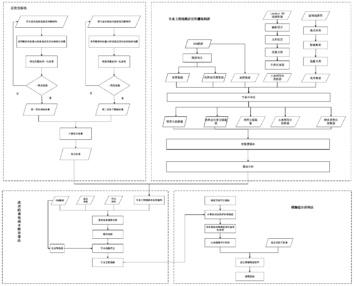
[0077] Such as figure 1 As shown, the present invention has designed a kind of route planning method of water diversion project in high-altitude mountainous area, is used for obtaining the route planning of water diversion project in target area, in the actual application process, specifically comprises the following steps:

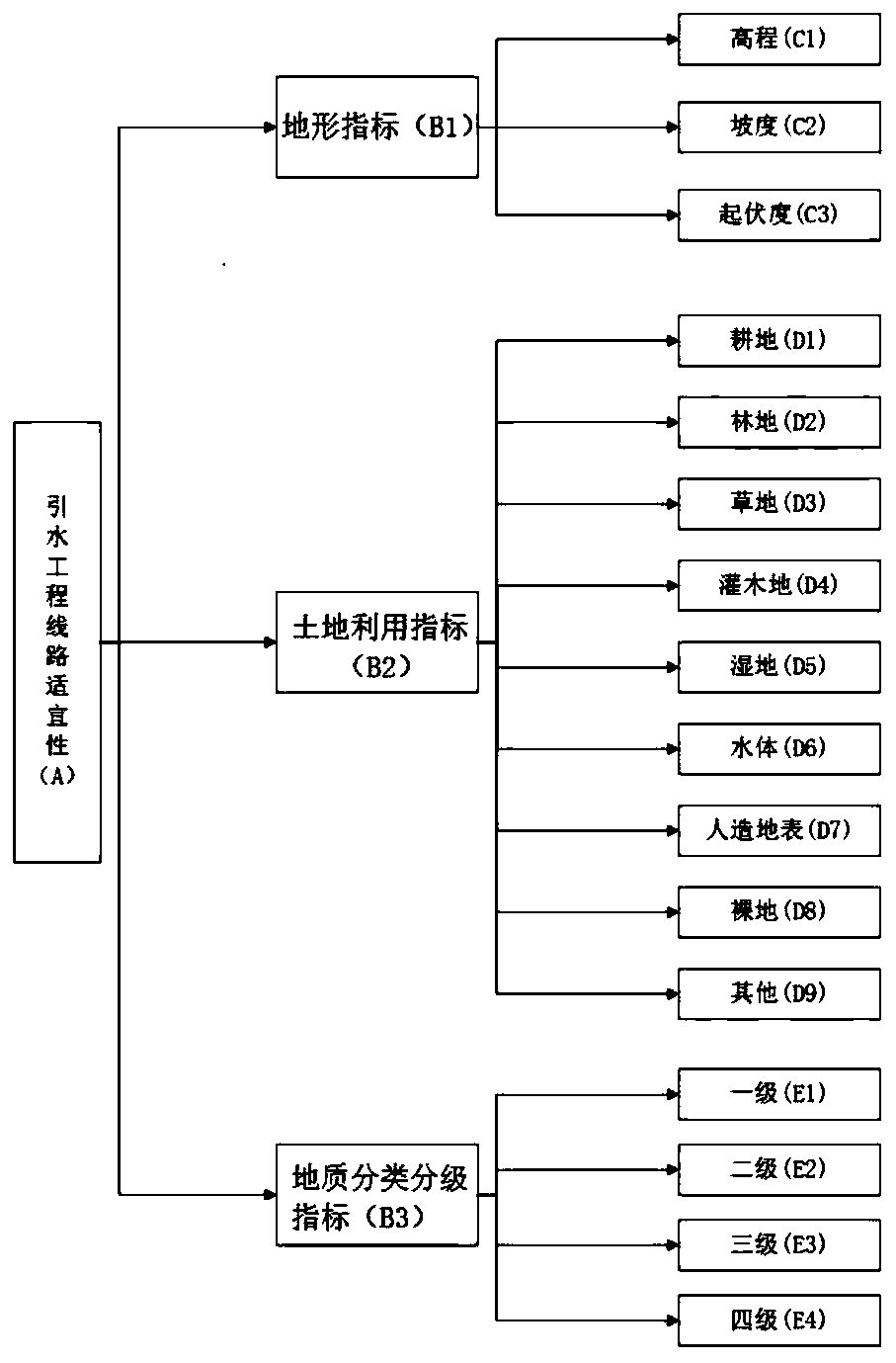
[0078] Step A. According to the topography and landform characteristics of the target area, each evaluation index for evaluating the suitability of the water diversion project line is obtained by screening, in practical application, such as figure 2 As shown, for all evaluation indicators, they are classified according to three types of terrain indicators, land use indicators, and geological classification and grading indicators, and then use the analytic hierarchy process to determine the weight o...


PUM


Abstract

The invention relates to a high-altitude mountain area water diversion engineering line planning method. The method comprises steps that firstly, water diversion engineering line suitability evaluation indexes are screened according to high-altitude mountain area landform characteristics, and weight of each evaluation index is determined through employing the hierarchy analytical method; secondly, statistics grading or experience grading is carried out according to contribution or restriction of each evaluation index to water diversion engineering line suitability, assignment is carried out, and a water diversion engineering line suitability grid is generated through utilizing a weight superposition analytical method; an improved Dijkstra shortest path algorithm is utilized, based on the water diversion engineering line suitability grid, a water diversion engineering line path with minimum cost is solved and is taken as a water diversion engineering line plan; and lastly, a fuzzy comprehensive evaluation method is utilized to evaluate the water diversion engineering line planning scheme. The method is advantaged in that the method plays an important role for high-altitude mountain area water diversion engineering line planning, disadvantages of time consuming, labor consuming and inconsiderate thinking existing in artificial planning are solved to a certain degree, and application prospects are wide.

Description

technical field [0001] The invention relates to a method for planning a route of a water diversion project in a high-altitude mountain area, and belongs to the technical field of water diversion project planning. Background technique [0002] Taking the route planning of the water diversion project in high-altitude mountainous areas as the research goal, it is proposed to use the analytic hierarchy process, the improved least cost path algorithm, the intelligent terrain algorithm and the fuzzy comprehensive evaluation method to obtain the route planning scheme and evaluation of the water diversion project. On the premise of comprehensively considering multiple evaluation indicators such as topography, geology, and land use, and around the overall goal of intelligent route selection for water diversion projects, a step-level model that can reflect the nature of water diversion project route selection and the internal relationship between the geographical environment is establi...

Claims


Application Information

Patent Timeline
Patent Type & Authority Patents(China)
IPC IPC(8): G06Q10/04G06Q50/06
CPCG06Q10/04G06Q50/06
Inventor 葛莹鲍倩陈刚锐童麟凯
Owner HOHAI UNIV
Why Eureka
Try Eureka