Calculation method and device for planned route

A technology for planning routes and calculation methods, applied to measuring devices, road network navigators, instruments, etc., can solve problems affecting driving speed, regulatory information failure, time changes, etc., to avoid violations of traffic regulations and detours, reduce traffic Storage and calculation space, the effect of reducing the possibility of change

Inactive Publication Date: 2018-06-01
SHENYANG MXNAVI CO LTD
View PDF6 Cites 6 Cited by
  • Summary
  • Abstract
  • Description
  • Claims
  • Application Information

AI Technical Summary

Problems solved by technology

[0002] In the existing car navigation, the route planning function considers the factors such as road restrictions and traffic lights. The general method is to create a time zone for the user based on the current time at the beginning of the route calculation. When the time regulation is in Within this time zone, the route will avoid this road section, but the time zone obtained from this is general and the accuracy is poor, so it is easy to cause the user to drive to this road section at an unregulated time point, and the route calculation process However, it avoids driving on this section of the road, causing the user to take the wrong driving route or detour; and during the driving process of the self-vehicle, due to many factors that will affect the driving speed, it may also cause the arrival time of the self-vehicle to change, or The previous regulatory information is invalid, causing the user to take an extra section of the road or a restricted road section; for example, a U-turn is prohibited after 17:00 at a certain intersection. After using the above method to plan the route, the time zone is not after 17:00. Route planning U-turn at this intersection, but due to road conditions, or delays in the middle, when the user drives to this intersection after 17:00, the user follows the original planned route prompts to make a U-turn, thus violating traffic regulations and may be punished accordingly

Method used


Image

  • Calculation method and device for planned route
  • Calculation method and device for planned route
  • Calculation method and device for planned route

Examples


Embodiment 1

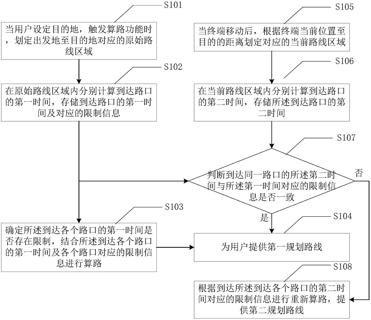
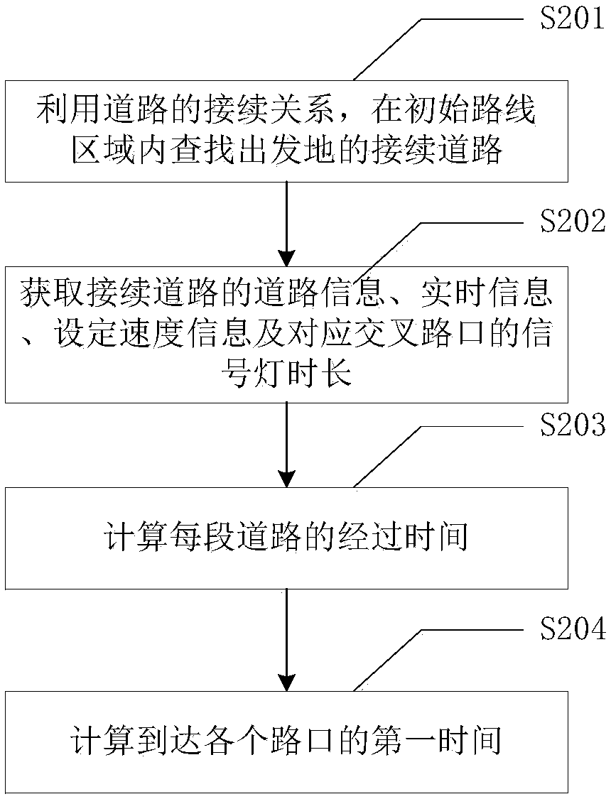
[0063] The present invention provides a calculation method and device for a planned route. Firstly, according to the location of the departure place and the destination, the relevant road and intersection information within a certain range is acquired; the speed information stored in the navigation is used to estimate and calculate the time to reach each intersection , calculate the route by obtaining the corresponding restriction information at the corresponding time, and provide an initial planned route; after the user walks according to the initial planned route, reacquire the relevant road and intersection information within the range determined by the current location and destination, Combined with the actual walking speed and real-time information at that time, recalculate the arrival time at each intersection, and compare the arrival time stored in the first calculation with the arrival time obtained by the current calculation to determine whether they belong to the same ...

Embodiment 2

[0147] This embodiment provides a method for recommending route planning, the method including:

[0148] S301 Receive a route calculation instruction and determine an initial route area;

[0149] S302 Calculate the first time to arrive at the intersection in the initial route area, and determine at least one original recommended route in combination with the restriction rules corresponding to the intersection;

[0150] S303 acquires the current location of the terminal, and determines the unpassed intersections on the original recommended route;

[0151] S304 Judging the consistency between the second time of arriving at an unpassed intersection on the original recommended route and the first time, and determining whether to calculate at least one alternative recommended route.

[0152] Further, determine the initial route area, including:

[0153] The locations of the origin and the destination are respectively determined, and the first closed area is set with the distance ...


PUM


Abstract

The invention discloses a calculation method and device for a planned route. When an initial route is planned, first time for reaching each intersection is calculated by adopting the departure as a starting point according to road continuity, whether the first time for reaching each intersection is limited or not is judged, route calculation is performed by combination of the first time for reaching each intersection and limiting information corresponding to each intersection, and an original recommended route is provided; second time for reaching each intersection is calculated according to the current position of a user after advancing; whether the second time for reaching the same intersection is consistent with the limiting information corresponding to the first time is judged, so thatwhether the route is required to be re-planned or not is determined. According to the method, effective planned route calculation is performed by sufficiently utilizing the road restriction information, a more accurate planned route is provided for the user, and behaviors of violation of traffic rules, detouring and the like due to misguidance are effectively avoided.

Description

technical field [0001] The invention relates to a calculation method and device for a planned route. Background technique [0002] In the existing car navigation, the route planning function considers the factors such as road restrictions and traffic lights. The general method is to create a time zone for the user based on the current time at the beginning of the route calculation. When the time regulation is in Within this time zone, the route will avoid this road section, but the time zone obtained from this is general and the accuracy is poor, so it is easy to cause the user to drive to this road section at an unregulated time point, and the route calculation process However, it avoids driving on this section of the road, causing the user to take the wrong driving route or detour; and during the driving process of the self-vehicle, due to many factors that will affect the driving speed, it may also cause the arrival time of the self-vehicle to change, or The previous reg...

Claims


Application Information

Patent Timeline
Patent Type & Authority Applications(China)
IPC IPC(8): G01C21/34
CPCG01C21/3415G01C21/3492
Inventor 徐雁鹏王利鹏魏毅韩文敬
Owner SHENYANG MXNAVI CO LTD
Why Eureka
Try Eureka