A method of site selection for construction land in mountainous areas based on arcgis

A technology for construction land and mountainous areas, applied in data processing applications, geographic information databases, instruments, etc., can solve problems such as high subjective influence, low work efficiency, and economic losses, so as to avoid site selection errors, save manpower and material resources, and avoid The effect of wrong choice

Active Publication Date: 2022-06-24
梅州市城市规划设计院有限公司
View PDF9 Cites 0 Cited by
  • Summary
  • Abstract
  • Description
  • Claims
  • Application Information

AI Technical Summary

Problems solved by technology

[0003] In the past, the delineation of construction land in complex mountainous areas often required leaders and designers to repeatedly visit the site and determine based on experience, which took a long time and was inefficient, subjectivity was greatly affected, and site selection errors were prone to occur, resulting in economic losses

Method used


Image

  • A method of site selection for construction land in mountainous areas based on arcgis

Examples


Embodiment

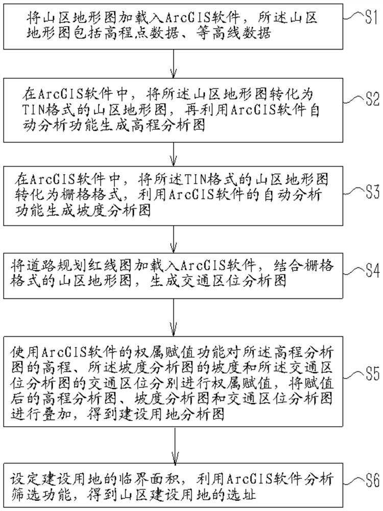
[0020] Example: as figure 1 As shown, the present invention provides a technical solution, a method for site selection of construction land in mountainous areas based on ArcGIS, comprising the following steps:

[0021] Step S1: Load the mountain topographic map into ArcGIS software, where the mountain topographic map includes elevation point data and contour line data;

[0022] Step S2: In ArcGIS software, convert the mountain topographic map into a mountain topographic map in TIN (triangular irregular network, TIN for short) format, and then use the automatic analysis function of ArcGIS software to generate an elevation analysis map; TIN is a digital The representation of the elevation model is a model that is organized in a digital form according to a certain structure to represent the spatial distribution of actual terrain features. ArcGIS software can set the attributes of the model and divide the elevation level.

[0023] Step S3: in ArcGIS software, convert the mountain...


PUM


Abstract

The invention discloses a site selection method for construction land in mountainous areas based on ArcGIS. On the basis of topographic maps in mountainous areas, the elevation, slope and traffic location analysis functions of ArcGIS or similar software are used to quickly screen out suitable development sites through superposition and assignment. land for construction. The method provided by the invention uses software to analyze and screen the data of mountain topographic maps to finally determine the location of construction land in mountainous areas. Compared with the previous method of manual on-site survey and manual selection of construction land by technicians, it avoids manual subjective selection. It is easy to make selection mistakes, and it does not require a lot of on-site survey work, saving manpower and material resources.

Description

technical field [0001] The invention relates to the technical field of urban planning, in particular to an ArcGIS-based site selection method for construction land in mountainous areas. Background technique [0002] With the urbanization process and social and economic development in China, the demand for construction land in various regions is increasing, and the protection of basic farmland is a long-term basic national policy in my country. Therefore, more and more cities are beginning to look for construction in mountainous areas. land. However, due to slope, elevation and other reasons, the land in mountainous areas often needs to undergo engineering transformation before it can be used. How to effectively balance the cost of the leveling project and the benefits of land development has become the first factor to be considered when delimiting the scope of construction land in the mountainous area, and sometimes also includes ecological environmental protection. and othe...

Claims


Application Information

Patent Timeline
Patent Type & Authority Patents(China)
IPC IPC(8): G06F16/29G06Q10/06G06Q50/08
CPCG06Q10/0637G06Q50/08
Inventor 黄勇温伟达邹丹平丘克涌曾汉鹏
Owner 梅州市城市规划设计院有限公司
Why Eureka
Try Eureka