A spatial data matching method for urban gas professional pipelines and comprehensive pipelines

A technology that integrates pipelines and spatial data, applied in the field of geographic information, can solve the problems of low efficiency, lack of integrity, lack of methods to solve large-scale spatial data matching, etc., to save financial investment and improve the efficiency of fund use.

Active Publication Date: 2021-10-19
NANJING NORMAL UNIVERSITY
View PDF7 Cites 0 Cited by
  • Summary
  • Abstract
  • Description
  • Claims
  • Application Information

AI Technical Summary

Problems solved by technology

Due to the lack of a comprehensive underground pipeline data matching model, the lack of solutions to large-scale spatial data matching, and the lack of efficient and convenient pipeline data matching tools, relevant departments of pipelines still use inefficient manual matching methods for data matching

Method used


Image

  • A spatial data matching method for urban gas professional pipelines and comprehensive pipelines
  • A spatial data matching method for urban gas professional pipelines and comprehensive pipelines
  • A spatial data matching method for urban gas professional pipelines and comprehensive pipelines

Examples


Embodiment Construction

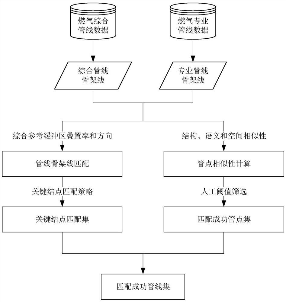
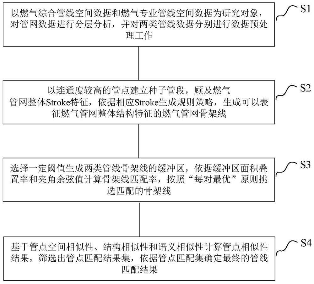
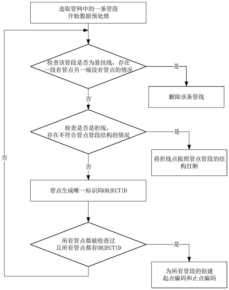
[0055] Embodiments of the technical solutions of the present invention will be described in detail below in conjunction with the accompanying drawings. The following examples are only used to illustrate the technical solution of the present invention more clearly, so they are only examples, and should not be used to limit the protection scope of the present invention. It should be noted that, unless otherwise specified, the technical terms or scientific terms used in this application shall have the usual meanings understood by those skilled in the art to which the present invention belongs. Below in conjunction with accompanying drawing and specific embodiment the present invention is described in further detail: as figure 2 As shown, the implementation of the present invention discloses a spatial data matching method for urban gas professional pipelines and comprehensive pipelines, including the following steps:

[0056] (1) Taking the spatial data of comprehensive gas pipe...


PUM


Abstract

The present invention disclosed a spatial data matching method for urban gas professional pipelines and integrated pipelines. The methods include: analyze the distribution characteristics of urban underground gas pipeline networks by layered methods, and conduct data pre -processing of pipeline data; take into account gas pipelines; take into account gas pipelines;The characteristics of the network Stroke and the structural characteristics of the gas pipe network are generated to generate the gas pipe network skeleton line; the key structural point matching results of the gas pipe network are generated according to the results of the skeleton line;Generate pipe matching results set, and finally complete the pipe matching according to the pipe matching result.The invention targets the problem of "two data, repeated detection" in the urban underground pipeline, and uses the GIS vector space data matching method to complete the comprehensive gas pipeline space data and professional gas pipelines on the basis of analyzing the overall morphological structure characteristics of the gas pipe network.Matching space data.

Description

technical field [0001] The invention relates to the field of geographic information, in particular to a spatial data matching method for professional urban gas pipelines and comprehensive pipelines. Background technique [0002] Urban underground pipelines are an important part of urban infrastructure. They are responsible for transmitting information and transporting energy. They are the material basis for the survival and development of cities. They are called the "lifeline" and "bloodline" of cities. With the construction of "smart cities", urban underground pipeline data has become an important content of underground space information resources, and has been widely used in urban planning and design, emergency event handling, underground space development and other fields. [0003] Due to the difference in management mode and application purpose, the current pipeline data is divided into two categories: comprehensive underground pipeline data and professional underground ...

Claims


Application Information

Patent Timeline
Patent Type & Authority Patents(China)
IPC IPC(8): G06F16/29G06F16/245G06Q50/06
CPCG06Q50/06
Inventor 张书亮焦一峰王铭楠王智慧江游戴梦奇龚之妍
Owner NANJING NORMAL UNIVERSITY
Why Eureka
Try Eureka