Vehicle geomagnetic matching and positioning method and system under road network environment

A technology of geomagnetic matching and positioning method, which is applied in ground navigation and other directions, and can solve problems such as complex vehicle road network, wrong matching, and poor real-time performance of global matching calculations

Active Publication Date: 2019-01-04
ACAD OF OPTO ELECTRONICS CHINESE ACAD OF SCI +1
View PDF8 Cites 0 Cited by
  • Summary
  • Abstract
  • Description
  • Claims
  • Application Information

AI Technical Summary

Problems solved by technology

The characteristic of using the geomagnetic matching positioning system as a vehicle positioning method is that its positioning error will not diverge over time, but it also has weaknesses: first, the vehicle road network is complex, the real-time performance of global matching calculation is poor, and it is easy to introduce interference road sections; The vehicle is at the intersection, due to the randomness of the driving direction, it is prone to the problem of wrong matching, which makes it unable to provide continuous positioning results

Method used


Image

  • Vehicle geomagnetic matching and positioning method and system under road network environment
  • Vehicle geomagnetic matching and positioning method and system under road network environment
  • Vehicle geomagnetic matching and positioning method and system under road network environment

Examples


Embodiment 1

[0070] This embodiment provides a vehicle geomagnetic matching positioning method in a road network environment, including the following steps:

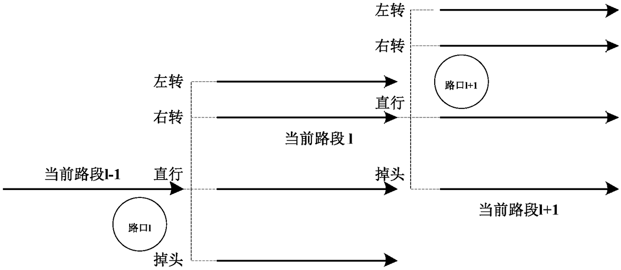
[0071] S1: Obtain the geomagnetic field data of the vehicle's driving route in real time, the mileage traveled by the vehicle, the heading of the vehicle, and the estimated value of the vehicle's driving position in the road network environment.

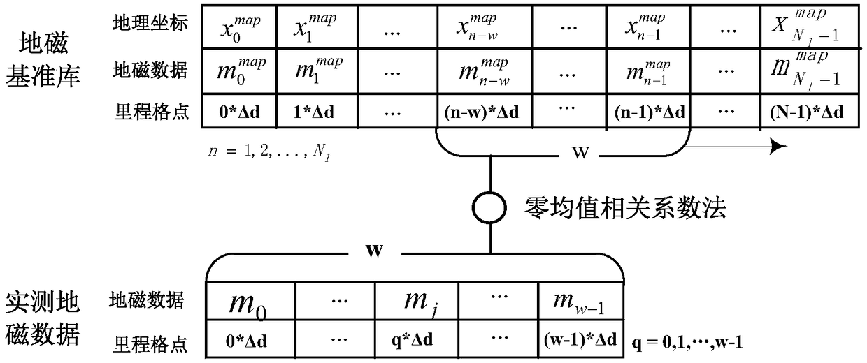
[0072] It should be noted that dead reckoning is the basic method of vehicle positioning, and its principle is to use heading and mileage sensors to calculate the vehicle position. The following describes how to obtain the estimated value of the vehicle's driving position in the road network environment, specifically:

[0073] Get the starting position of the vehicle (e 0 ,n 0 ); where e 0 is the initial east position, n 0 is the initial north position.

[0074] According to the starting position (e 0 ,n 0 ), to obtain the estimated value of the driving position at the kth moment (e ...

Embodiment 2

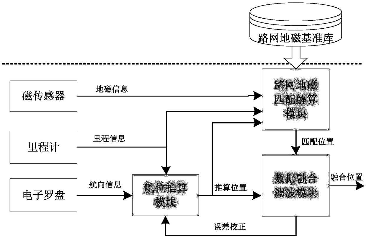
[0124] Based on the above embodiments, this embodiment also provides a vehicle geomagnetic matching and positioning system in a road network environment. see image 3 , which is a functional block diagram of a vehicle geomagnetic matching and positioning system in a road network environment provided by this embodiment. A vehicle geomagnetic matching positioning system in a road network environment, comprising a magnetic sensor, an odometer, an electronic compass, a dead reckoning module, a road network geomagnetic matching calculation module, and a data fusion filtering module;

[0125] The magnetic sensor is used to collect the geomagnetic field data on the vehicle driving route in real time; the odometer is used to measure the mileage traveled by the vehicle; the electronic compass is used to measure the heading of the vehicle; the dead reckoning module is used to The mileage and heading are estimated values ​​of the real-time driving position of the vehicle in the road net...


PUM


Abstract

The invention provides a vehicle geomagnetic matching and positioning method under a road network environment. The method includes the steps of recognizing a go-straight road section, a turn-left roadsection, a turn-right road section and a turn-around road section of an initial driving road when a vehicle is going to pass by a crossing, recognizing whether a current driving road section of the vehicle is the go-straight road section, the turn-left road section, the turn-right road section or the turn-around road section of the initial driving road after the vehicle passes by the crossing through a maximum correlation coefficient method to obtain a current matched position of the vehicle so that the vehicle can be switched to be positioned from the initial driving road section to the current driving road section, conducting fusing and filtering treatment on a driving position reckoning value and the current matched position so that the performance advantage complementation of a geomagnetic matching / dead reckoning system can be realized. The positioning result is continuous and reliable, and the autonomous positioning requirement of the vehicle under the long-distance complicated road network environment can be met.

Description

technical field [0001] The invention belongs to the technical field of vehicle autonomous positioning, and in particular relates to a vehicle geomagnetic matching positioning method and system in a road network environment. Background technique [0002] Among the main solutions for vehicle positioning, the inertial navigation system (Inertial Navigation System, INS) and the dead reckoning system (Dead Reckoning, DR) have been widely used, but the essence of the two is the vehicle trajectory calculation based on the integral of the change. Therefore, due to the measurement error of the inertial device and the odometer, a cumulative offset of the positioning result will be formed. The Global Navigation Satellite System (GNSS) can provide all-weather, all-time global positioning, but it is based on the wireless signal ranging mechanism, and the satellite signal is vulnerable to occlusion, multipath, radio interference, etc. in the complex urban road network environment. Unable...

Claims


Application Information

Patent Timeline
Patent Type & Authority Applications(China)
IPC IPC(8): G01C21/08
CPCG01C21/08
Inventor 纪新春魏东岩李雯袁洪来奇峰孟令辉
Owner ACAD OF OPTO ELECTRONICS CHINESE ACAD OF SCI
Why Eureka
Try Eureka