A method and device for automatic correction of fault polygon drawing

An automatic correction and polygon technology, applied in the field of data processing, can solve the problem of low precision of geological structure map

Inactive Publication Date: 2020-06-12
储伟文
View PDF3 Cites 0 Cited by
  • Summary
  • Abstract
  • Description
  • Claims
  • Application Information

AI Technical Summary

Problems solved by technology

[0007] The purpose of the present invention is to provide an automatic correction method and device for fault polygon drawing, which is used to solve the problem of low precision in the automatic drawing of geological structure maps by existing machines, so as to improve the accuracy of geological structure maps while improving work efficiency

Method used


Image

  • A method and device for automatic correction of fault polygon drawing
  • A method and device for automatic correction of fault polygon drawing
  • A method and device for automatic correction of fault polygon drawing

Examples


Embodiment 1

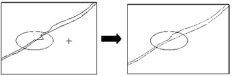
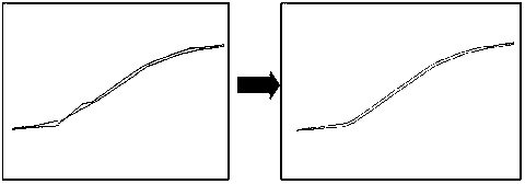
[0035] Embodiment 1 of the present invention provides a schematic flow chart of a method for automatically correcting a tomographic polygon drawing. This method is mainly to correct the original tomographic polygon drawing drawn after the traditional automatic machine recognition. In order to overcome the problems of the upper and lower disks of the fault polygon drawing drawn by the traditional method, there are intersection points, the horizontal fault distance is not balanced, the geological law is not met, the polygon is not smooth enough, there are many abrupt points, and the ends of the polygon are not annihilated.

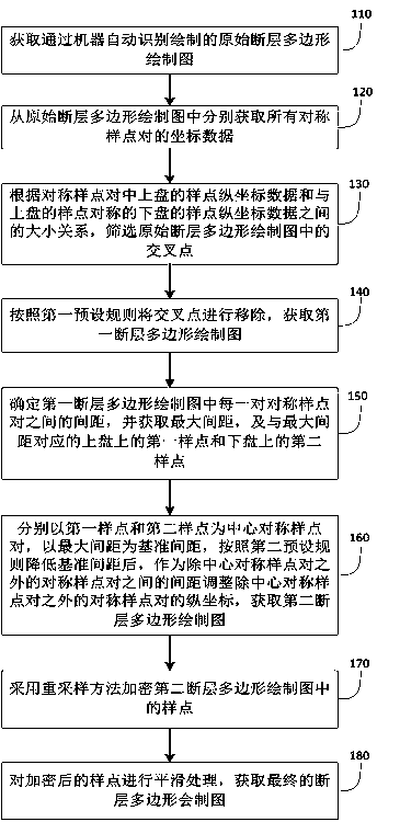
[0036] The method flow diagram is as detailed as figure 1 As shown, the method can include:

[0037] Step 110: Obtain an original tomographic polygon drawing drawn by automatic machine recognition.

[0038] Step 120: Obtain the coordinate data of all symmetric sample point pairs from the original tomographic polygon drawing.

[0039] Specifically, the machine autom...

Embodiment 2

[0060] Corresponding to embodiment 1, the embodiment of the present invention also provides an automatic correction device for tomographic polygon drawing, specifically as Figure 5 As shown, the device includes: an acquisition unit 501, a screening unit 502, a processing unit 503, and a sampling unit 504.

[0061] The acquiring unit 501 is configured to acquire the original tomographic polygon drawing map drawn by automatic machine recognition;

[0062] Obtain the coordinate data of all symmetric sample point pairs from the original fault polygon drawing. The symmetric sample point pairs are the symmetrical relationship between the sample points on the upper wall and the sample points on the lower wall;

[0063] The screening unit 502 is used to screen the original tomographic polygon drawing based on the size relationship between the ordinate data of the sample points on the hanging wall in the symmetrical sample point pair and the ordinate data of the sample points on the bottom w...

Embodiment 3

[0079] In addition, an embodiment of the present invention also provides a computer-readable storage medium on which computer program instructions are stored, and when the program instructions are executed by a processor, the method steps of the foregoing embodiment 1 are implemented.


PUM


Abstract

The invention discloses an automatic correction method and device of a fault polygon drawn map. The method includes the following steps that: an original fault polygon drawn map is automatically recognized; the coordinate data of all symmetric sample point pairs are acquired; intersection points are screened out and removed according to the magnitude relation between the sample point vertical coordinate data of a hanging side and the sample point vertical coordinate data of a heading side corresponding to the hanging side in the symmetric sample point pairs, and a first fault polygon drawn mapis obtained; and an interval between two sample points in each sample point pair in the first fault polygon drawn map is determined, a maximum interval, a first point and a second point are obtained;after a reference interval is reduced according to a second preset rule, the vertical coordinates of all the symmetric sample point pairs except the center symmetric sample point pair are adjusted according to the interval between two sample points in each symmetric sample point pair except the center symmetric sample point pair, so that a second fault polygon drawn map is obtained; and sample points in the second fault polygon drawn map are encrypted and are subjected to smoothing processing.

Description

Technical field [0001] The invention relates to the technical field of data processing, in particular to a method and device for automatically correcting a tomographic polygon drawing map. Background technique [0002] In the current oil and ore prospecting work in the geological industry, the compilation of structural maps is an important work content, mainly using kinematic information such as reflection time, homogeneity, and wave speed of seismic wave changes to study the distribution range and fluctuations of the formation interface Shape, fault development, and transform the travel time in the seismic event profile into the depth of the stratigraphic interface, draw geological structure maps, and provide data for finding structural oil and gas reservoirs. Among them, the plane drawing of fault polygons (polygons) is an important part of it, and its drawing accuracy directly affects the mapping accuracy of the structure map, and the accuracy of the structure map directly aff...

Claims


Application Information

Patent Timeline
Patent Type & Authority Patents(China)
IPC IPC(8): G01V1/28G01V1/36
CPCG01V1/282G01V1/362G01V2210/59G01V2210/74
Inventor 储伟文李昂
Owner 储伟文
Why Eureka
Try Eureka