An automatic correction method and device for drawing a fault polygon map

An automatic correction, polygon technology, applied in the field of data processing, can solve the problem of low accuracy of geological structure map

Active Publication Date: 2019-02-12
中国地质调查局沈阳地质调查中心
View PDF5 Cites 1 Cited by
  • Summary
  • Abstract
  • Description
  • Claims
  • Application Information

AI Technical Summary

Problems solved by technology

[0006] The purpose of the embodiment of the present invention is to provide a fault polygon drawing automatic correction method and device for the low accuracy of the existing machine automatic drawing geological structure map problems, so as to improve work efficiency and improve the accuracy of geological structure maps

Method used


Image

  • An automatic correction method and device for drawing a fault polygon map
  • An automatic correction method and device for drawing a fault polygon map
  • An automatic correction method and device for drawing a fault polygon map

Examples


Embodiment 1

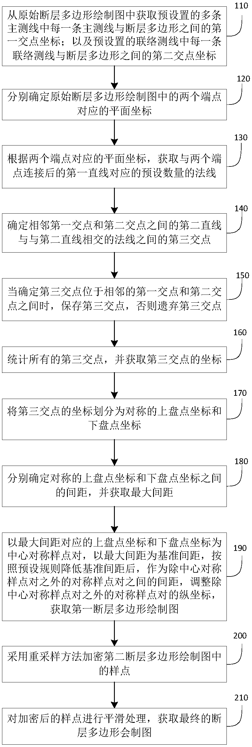
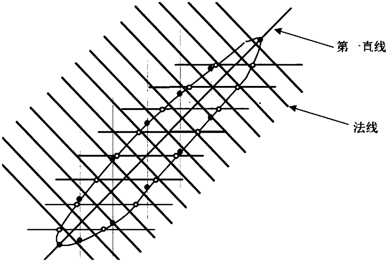
[0040] Embodiment 1 of the present invention provides a schematic flowchart of a method for automatic correction of tomographic polygon drawing. This method is mainly to correct the original fault polygon drawn after the traditional machine automatic recognition. In order to overcome the problems that the horizontal fault distance in the fault polygon drawn by the traditional method is not balanced enough, does not conform to the geological law, the polygon is not smooth enough, there are many mutation points, and the two ends of the polygon are not annihilated.

[0041] The flow chart of the method is as follows: figure 1 As shown, the method may include:

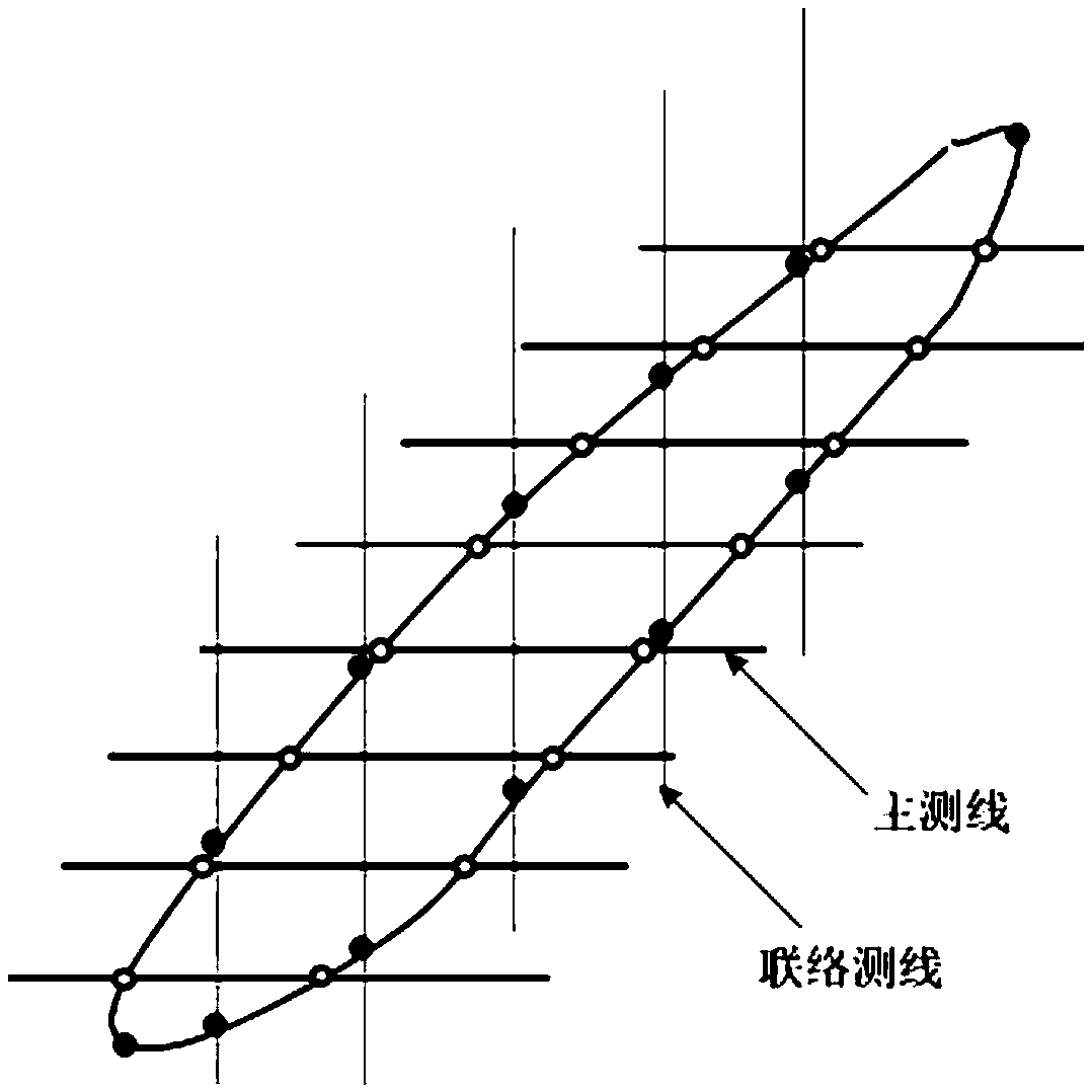
[0042] Step 110, obtaining the coordinates of the first intersection point between each of the preset multiple main survey lines and the fault polygon from the original tomographic polygon drawing; and each of the preset contact survey lines and the Second intersection coordinates between fault polygons.

[0043]Specifi...

Embodiment 2

[0071] Corresponding to Embodiment 1, the embodiment of the present invention also provides an automatic correction device for tomographic polygon drawing, specifically as Figure 7 As shown, the device includes: an acquisition unit 701 , a processing unit 702 , a statistics unit 703 and an encryption unit 704 .

[0072] An acquisition unit 701, configured to acquire the coordinates of the first intersection between each of the preset multiple main survey lines and the fault polygon from the original tomographic polygon drawing; and each of the preset contact survey lines The coordinates of the second intersection point between the survey line and the fault polygon, the original fault polygon will be drawn as a fault polygon drawn through automatic machine identification;

[0073]Respectively determine the plane coordinates corresponding to the two endpoints in the original tomographic polygon drawing diagram, wherein the plane coordinates corresponding to the two endpoints ar...

Embodiment 3

[0091] In addition, an embodiment of the present invention also provides a computer-readable storage medium, on which computer program instructions are stored, and when the program instructions are executed by a processor, the method steps of the above-mentioned embodiment 1 are implemented.


PUM


Abstract

The invention discloses an automatic correction method and device for drawing a fault polygon map. The method comprises the following steps of obtaining a first intersection point coordinate between the fault polygon and a main survey line and a second intersection point coordinate between the fault polygon and the contact survey line; determining the plane coordinates corresponding to the two endpoints respectively; acquiring a preset number of normals corresponding to the first straight line after the two endpoints are connected; determining a third intersection point between a second straight line between an adjacent first intersection point and a second intersection point and a normal intersecting the second straight line; storing a third intersection point when it is determined thatthe third intersection point is located between an adjacent first intersection point and a second intersection point; counting all the coordinates of the third intersection point, and dividing into symmetrical coordinates of the upper inventory point and the lower inventory point coordinate; determining a distance between symmetrical upper count coordinates and lower count coordinates; adjusting the longitudinal coordinates of symmetrical sample pairs after the maximum spacing is taken as the reference spacing and the reference spacing is reduced according to the preset rules; smoothing afterusing resampling method to encrypt, thereby obtaining the final fault polygon.

Description

technical field [0001] The invention relates to the technical field of data processing, in particular to a method and device for automatically correcting a tomographic polygon drawing. Background technique [0002] In the current oil and ore prospecting work in the geological industry, the compilation of structural maps is an important work content. It mainly uses kinematic information such as reflection time, in-phase, and wave velocity of seismic wave changes to study the distribution range and fluctuation of stratigraphic boundaries. Morphology, fault development, and the travel time in the seismic event profile is converted into the depth of the stratigraphic interface, and the geological structure map is drawn to provide basic information for searching for structural oil and gas reservoirs. Among them, the plane drawing of fault polygons (polygons) is an important part, and its drawing accuracy directly affects the mapping accuracy of the structural map, and the accurac...

Claims


Application Information

Patent Timeline
IPC IPC(8): G06T11/20
CPCG06T11/203
Inventor 李昂张丽艳
Owner 中国地质调查局沈阳地质调查中心
Why Eureka
Try Eureka