Map rendering method and device, storage medium, and electronic device

A map and rendering instruction technology, applied in 2D image generation, image data processing, filling planes with attributes, etc., can solve problems such as inaccurate boundaries

Active Publication Date: 2019-03-29
TENCENT TECH (SHENZHEN) CO LTD
View PDF9 Cites 9 Cited by
  • Summary
  • Abstract
  • Description
  • Claims
  • Application Information

AI Technical Summary

Problems solved by technology

[0006] Embodiments of the present invention provide a map rendering method and device, a storage medium, and an electronic device, so as to at least solve the technical problem of inaccurate boundaries of road inflection point areas rendered on a map in the related art

Method used


Image

  • Map rendering method and device, storage medium, and electronic device
  • Map rendering method and device, storage medium, and electronic device
  • Map rendering method and device, storage medium, and electronic device

Examples


Embodiment Construction

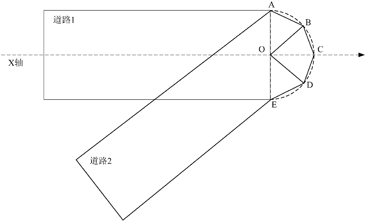
[0025] In order to enable those skilled in the art to better understand the solutions of the present invention, the following will clearly and completely describe the technical solutions in the embodiments of the present invention in conjunction with the drawings in the embodiments of the present invention. Obviously, the described embodiments are only It is an embodiment of a part of the present invention, but not all embodiments. Based on the embodiments of the present invention, all other embodiments obtained by persons of ordinary skill in the art without making creative efforts shall fall within the protection scope of the present invention.

[0026] It should be noted that the terms "first" and "second" in the description and claims of the present invention and the above drawings are used to distinguish similar objects, but not necessarily used to describe a specific sequence or sequence. It is to be understood that the data so used are interchangeable under appropriate ...


PUM


Abstract

The invention discloses a map rendering method and device, a storage medium and an electronic device. The method comprises the following steps: obtaining a rendering instruction for at least indicating to render an inflection point between a first road segment and a second road segment in a map; in response to a render instruction, finding the first coordinate point and the second coordinate pointin the map, a first side of the first region where the first vertex is located intersects with a second side of the second region where the second vertex is located at the first coordinate point, anextension line of the third side of the first region where the first vertex is located intersects with an extension line of the fourth side of the second region where the second vertex is located at the second coordinate point; According to the first coordinate point, the second coordinate point, the first vertex and the second vertex, an arc for connecting the first vertex and the second vertex is rendered. The invention solves the technical problem that the boundary of the inflection point area of the road rendered on the map is inaccurate in the related art.

Description

technical field [0001] The present invention relates to the field of electronic maps, in particular to a map rendering method and device, a storage medium, and an electronic device. Background technique [0002] The symbolization method of geospatial entities is an important research content in the field of geographic information and cartography. Compared with commonly used point symbols and surface symbols, line symbols are often more difficult and time-consuming because they need to be filled and drawn along the direction of linear elements. In addition to the commonly used solid lines and dashed lines, the line symbols required in map representations are more complex. For example, the linear symbol of a major urban road is a double-line graphic entity with a border; the railway symbol is a black and white graphic entity with a border; the single-sided boundary line symbol is a tooth-shaped graphic entity. These line symbols combine different geometric shapes into a prim...

Claims


Application Information

Patent Timeline
Patent Type & Authority Applications(China)
IPC IPC(8): G06T11/20G06T11/40
CPCG06T11/206G06T11/40
Inventor 李鸣宋小建陈明亮肖旺裕何朝阳
Owner TENCENT TECH (SHENZHEN) CO LTD
Why Eureka
Try Eureka