A Ship Detection Method in Satellite Imagery Combining Rotating Frame and Context Information

A technology for ship detection and satellite imagery, applied in the field of satellite image recognition, can solve the problem that satellite images are difficult to obtain ideal results, and achieve the effects of improving data shortage, reducing false alarm rate, and overcoming the interference of complex backgrounds

Active Publication Date: 2021-08-31
NO 54 INST OF CHINA ELECTRONICS SCI & TECH GRP
View PDF11 Cites 0 Cited by
  • Summary
  • Abstract
  • Description
  • Claims
  • Application Information

AI Technical Summary

Problems solved by technology

However, these methods are specially designed for object detection in natural images, and it is often difficult to achieve ideal results when directly applied to satellite images.

Method used


Image

  • A Ship Detection Method in Satellite Imagery Combining Rotating Frame and Context Information
  • A Ship Detection Method in Satellite Imagery Combining Rotating Frame and Context Information
  • A Ship Detection Method in Satellite Imagery Combining Rotating Frame and Context Information

Examples


Embodiment Construction

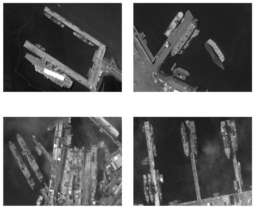
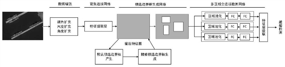
[0028] Object detection based on deep learning has recently received a lot of attention while achieving superior performance. However, due to a series of problems encountered in high-resolution satellite image ship detection, the existing ship detection methods are difficult to obtain high-precision detection results. Therefore, the present invention proposes a high-resolution satellite image ship detection method based on rotating frame and context information, and the specific flow chart is as follows figure 2 shown. Examples of ship targets in high-resolution satellite images are shown as figure 1 shown.

[0029] The specific embodiments and basic principles of the present invention will be further described below in conjunction with the accompanying drawings.

[0030] Step 1. Build a ship detection network model, including a densely connected network, a candidate bounding box generation network, and a multi-region fully connected network;

[0031] Step 2, data augment...


PUM


Abstract

The invention provides a satellite image ship detection method combined with rotating frame and context information. Firstly, color transformation, scale transformation and angle transformation are used to expand the training data set; Semantic information and feature maps with precise location information; then use the rotating region candidate network to generate a series of multi-scale, multi-aspect ratio, and multi-angle candidate bounding boxes on the feature map; finally use the multi-region fully connected network to extract candidate bounding boxes Context composite features are used for ship detection. Compared with the previous ship detection methods, the present invention can obtain higher detection accuracy from multiple perspectives such as data preprocessing, feature extraction, candidate bounding box generation, and detectors.

Description

technical field [0001] The invention belongs to the field of satellite image recognition, and more particularly relates to a satellite image ship detection method combined with rotating frames and context information. Background technique [0002] With the rapid development of remote sensing technology, current satellite sensors can easily acquire high-resolution images. Ship detection using high-resolution satellite images is an important research direction, and has been widely used in fishery management, ship traffic services, maritime operations and other fields. However, due to some significant differences between satellite images of ship targets and targets in natural images, such as: (1) the illumination changes, scale changes and aspect ratio changes of satellite image ship targets are more intense; (2) ship targets will encounter a large number of different complex environment, such as near-coastal environment, far-coastal environment, and interference from targets ...

Claims


Application Information

Patent Timeline
Patent Type & Authority Patents(China)
IPC IPC(8): G06K9/00G06N3/04G06N3/08
Inventor 于君娜王士成徐小刚陈金勇梁硕帅通单子力文义红王港楚博策
Owner NO 54 INST OF CHINA ELECTRONICS SCI & TECH GRP
Why Eureka
Try Eureka