A Hybrid Camera Calibration Method in Urban Environment

A hybrid camera and urban environment technology, applied in image analysis, image enhancement, instrumentation, etc., can solve problems such as lack of building tracking methods

Active Publication Date: 2020-12-25
ZHEJIANG UNIV OF TECH
View PDF14 Cites 0 Cited by
  • Summary
  • Abstract
  • Description
  • Claims
  • Application Information

AI Technical Summary

Problems solved by technology

[0005] In order to solve the problem of lack of tracking methods for urban outdoor buildings, the present invention provides a hybrid camera calibration method in an urban environment. The position information of the camera is obtained through high-precision GPS, and the orientation information of the camera is obtained through a gyroscope, and then the extrinsics of the camera

Method used


Image

  • A Hybrid Camera Calibration Method in Urban Environment
  • A Hybrid Camera Calibration Method in Urban Environment
  • A Hybrid Camera Calibration Method in Urban Environment

Examples


Embodiment Construction

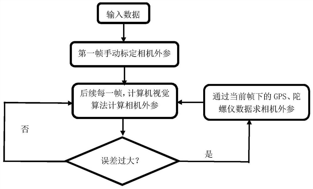
[0020] With reference to accompanying drawing, further illustrate the present invention:

[0021] A hybrid camera calibration method based on GIS technology, including the following steps:

[0022] Step 1. Manually calibrate the first frame.

[0023] Step 2. For each subsequent frame: track through the computer vision algorithm, if the tracking fails, go to step 3.

[0024] Step 3. Obtain the GPS and gyroscope data in the current frame, calculate the extrinsic parameter matrix and track the target, and then go to step 2.

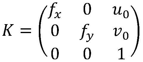
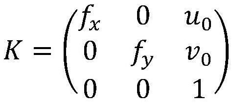
[0025] In step 1, the internal parameter matrix K of the camera needs to be provided, and its form is as follows:

[0026]

[0027] where f x and f y are the focal lengths of the camera in the horizontal and vertical directions, respectively, u 0 and v 0 are the principal point offsets in the horizontal and vertical directions. Then obtain the 2D point positions of the specified four 3D points on the image through mouse interaction, and then calcul...


PUM


Abstract

A hybrid camera calibration method in an urban environment can realize real-time urban building tracking in a complex environment by combining a high-precision GPS, gyroscope data and a computer vision tracking algorithm, and comprises the following steps: firstly, manually calibrating a first frame to obtain an external parameter matrix of a camera; secondly, for each following frame, a computervision algorithm is adopted for target tracking, and if the algorithm error is smaller than a given threshold value, the computer vision tracking algorithm is still adopted for the next frame; and ifthe algorithm error exceeds a given threshold value, solving the external parameters of the camera by adopting GPS and gyroscope data to realize target tracking under the current frame, and still adopting a computer vision tracking algorithm for the next frame. Each frame in the video is tracked in real time until the tracking is finished through continuous circulation between a computer vision tracking algorithm and a high-precision GPS and gyroscope data tracking method.

Description

technical field [0001] The invention relates to a hybrid camera calibration method. Background technique [0002] With the development of technology, more and more cities have constructed complete 3D model scenes, which is of great significance for how to effectively plan cities. The complete urban 3D scene also provides a wealth of 3D architectural models, which provide rich materials for the online visual registration of urban buildings. The online visual registration of urban buildings is to solve the camera position and attitude information based on the 3D-2D corresponding points in continuous video frames. Has a wide range of applications. [0003] In urban scenes, due to the occlusion problem between buildings, trees, pedestrians, and vehicles will also occlude buildings; in addition, the surface texture information of buildings is various, and it is difficult to deal with it uniformly, and light and shadow have great influence on texture. Information also has a lar...

Claims


Application Information

Patent Timeline
Patent Type & Authority Patents(China)
IPC IPC(8): G06T7/80G06T7/246G06T3/00
CPCG06T3/0031G06T2207/10016G06T7/246G06T7/80
Inventor 彭鹤年陈佳舟陆鹏飞秦绪佳
Owner ZHEJIANG UNIV OF TECH
Why Eureka
Try Eureka