Real-time geographic surveying and mapping acquisition system

A collection system and geographic technology, applied in the field of geographic surveying and mapping, can solve problems such as large amount of surveying and mapping data, complex three-dimensional modeling algorithms, and poor results, and achieve the effect of improving surveying and mapping accuracy.

Inactive Publication Date: 2019-08-06
杭州临安大地规划勘测有限公司
View PDF4 Cites 7 Cited by
  • Summary
  • Abstract
  • Description
  • Claims
  • Application Information

AI Technical Summary

Problems solved by technology

[0004] The existing technical solutions mentioned above have the following defects: in the actual surveying and mapping work, the amount of surveying and mapping data is large, the 3D mod

Method used


Image

  • Real-time geographic surveying and mapping acquisition system

Examples


Embodiment Construction

[0043] The present invention will be described in further detail below in conjunction with the accompanying drawings.

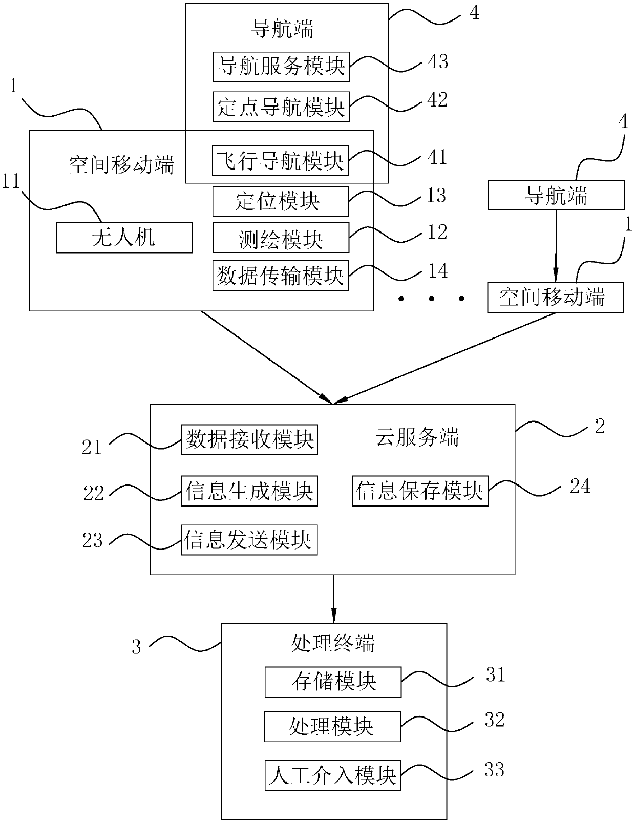
[0044] refer to figure 1 , is a real-time geographical surveying and mapping acquisition system disclosed in the present invention, including a space mobile terminal 1, a cloud server terminal 2, a processing terminal 3 and a navigation terminal 4.

[0045] The space mobile terminal 1 is used to collect and send the current surveying and mapping information, and the multiple space mobile terminals 1 correspond to the positions of different surveying and mapping subregions divided into the area to be surveyed and mapped. The space mobile terminal 1 includes an unmanned aerial vehicle 11 , which is a flying vehicle of the space mobile terminal 1 , and a surveying and mapping module 12 , a positioning module 13 and a data transmission module 14 are fixed on the unmanned aerial vehicle 11 .

[0046] The surveying and mapping module 12 is configured to perform ov...


PUM


Abstract

The invention discloses a real-time geographic surveying and mapping acquisition system, and relates to the technical field of geographic surveying and mapping. The system comprises a spatial mobile terminal used for collecting and sending current surveying and mapping information; a cloud server used for transferring surveying and mapping information; a processing terminal used for receiving andprocessing surveying and mapping information; wherein the processing terminal comprises a storage module used for storing and calling information in the processing terminal; and a processing module used for selecting a to-be-mapped area, drawing and forming a DEM model according to the mapping information received by the spatial mobile terminal and storing the DEM model in the storage module. Thespatial mobile terminal scans and maps the mapping subareas; mapping information is sent to the processing terminal through the cloud server; after receiving the surveying and mapping information, theprocessing terminal integrates and draws the surveying and mapping information to form a complete DEM model, a worker does not need to enter a surveying and mapping site, and performs surveying and mapping operation in real time in a manner that a plurality of spatial mobile terminals are distributed on the site, so that the surveying and mapping efficiency is improved, and the DEM model generation is rapidly performed on a wide area.

Description

technical field [0001] The invention relates to the technical field of geographic surveying and mapping, in particular to a real-time geographic surveying and mapping acquisition system. Background technique [0002] Geographical information is a collection that reflects geographic systems and related factors (including various information such as characteristics, dynamics, cycles, and distribution status). Surveying and mapping is a science that studies the acquisition, processing, description and application of geographic information. Its application scope is very wide. Surveying and mapping is used in tasks such as cadastral management. However, the use of traditional surveying instruments for surveying and mapping operations is time-consuming and the efficiency of surveying and mapping is low. At the same time, surveyors’ surveying and mapping accuracy will be affected by the outdoor environment, frequent operations, and fatigue, resulting in low measurement accuracy, w...

Claims


Application Information

Patent Timeline
IPC IPC(8): G06F9/50G06T17/05
CPCG06F9/5027G06F9/5072G06T17/05
Inventor 王娜娜孙建武潘晓明章镭
Owner 杭州临安大地规划勘测有限公司
Why Eureka
Try Eureka