Matching method, device and system for GNSS position and image in crowdsourcing map

A matching method and image technology, applied in satellite radio beacon positioning systems, measuring devices, radio wave measuring systems, etc., to achieve the effect of solving high-precision matching problems and reducing registration errors

Active Publication Date: 2019-08-27
BAIDU ONLINE NETWORK TECH (BEIJIBG) CO LTD
View PDF16 Cites 7 Cited by
  • Summary
  • Abstract
  • Description
  • Claims
  • Application Information

AI Technical Summary

Problems solved by technology

[0004] The purpose of the present invention is to reduce the registration error when crowdsourcing map collection equipment acquires image data and its GNSS position, and at least solve the problem of matching accuracy between GNSS position and camera frames

Method used


Image

  • Matching method, device and system for GNSS position and image in crowdsourcing map
  • Matching method, device and system for GNSS position and image in crowdsourcing map
  • Matching method, device and system for GNSS position and image in crowdsourcing map

Examples


Embodiment Construction

[0042] Specific embodiments of the present invention will be described in detail below in conjunction with the accompanying drawings. It should be understood that the specific embodiments described here are only used to illustrate and explain the present invention, and are not intended to limit the present invention.

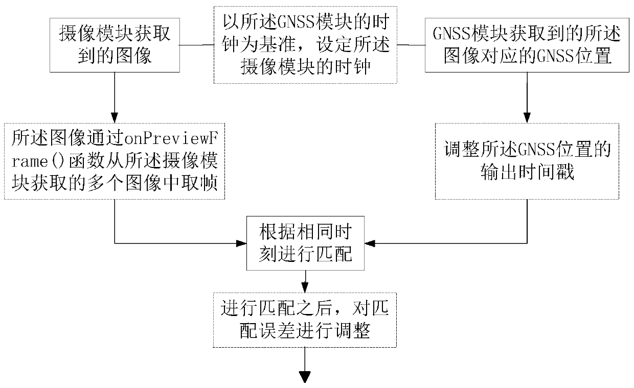
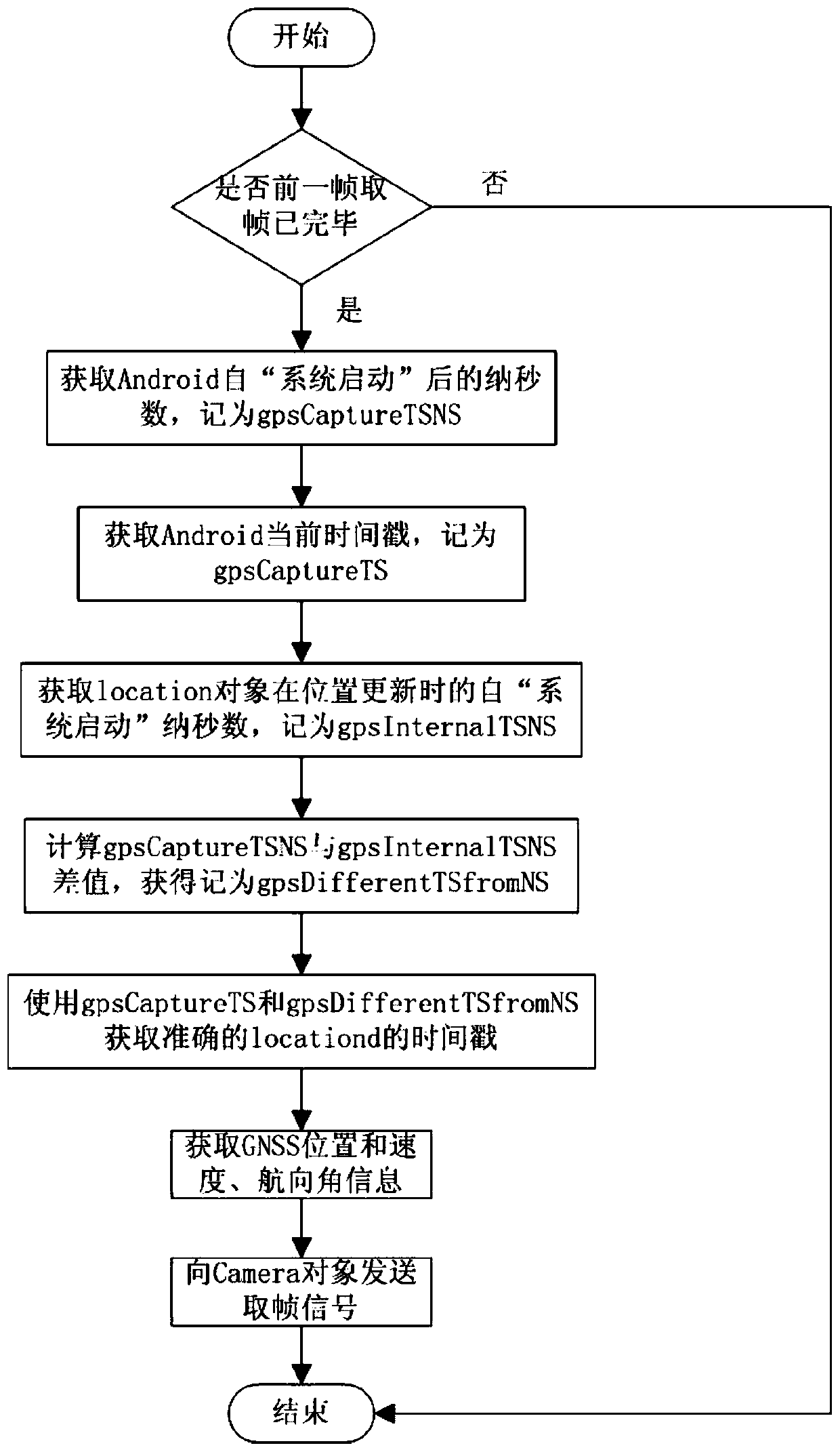
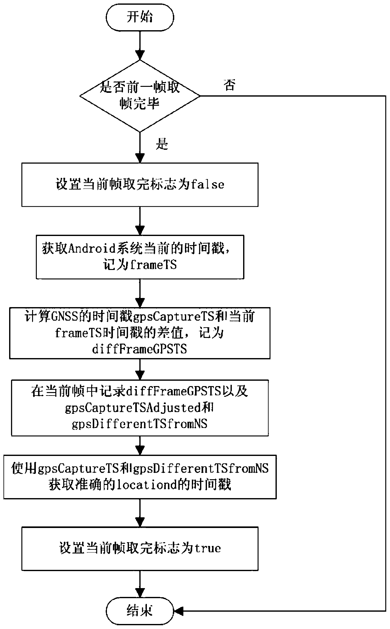
[0043] figure 1 is a schematic flowchart of a matching method provided by an embodiment of the present invention. Such as figure 1 As shown, the matching method of the GNSS position and the image in the crowdsourcing map includes the following steps: obtaining the image through the camera module, and obtaining the GNSS position corresponding to the image through the GNSS module, and performing the GNSS position and the image according to the same moment matching; the method also includes adopting at least one of the following methods to improve matching accuracy:

[0044] 1) taking the clock of the GNSS module as a reference, setting the clock of the camera m...


PUM


Abstract

The invention relates to the technical field of electronic maps, and discloses a matching method for a GNSS position and an image in a crowdsourcing map. The method comprises the step of: matching animage acquired by a camera module with a GNSS position corresponding to an image acquired by a GNSS module according to the same time point; the method further comprises at least one of the followingmanners for improving matching accuracy: (1) setting a clock of the camera module with a clock of the GNSS module as a reference; (2) regulating an output timestamp of the GNSS position; (3) framing from multiple images acquired by the camera module through an onPreviewFrame () function; and (4) after matching, regulating a matching error. The method can solve the problem of high-precision matching of the GNSS position and camera framing, and lowers registration errors.

Description

technical field [0001] The present invention relates to the field of maps, in particular to a method for matching GNSS positions and images in crowdsourced maps, a device for matching GNSS positions and images in crowdsourced maps, and a system for matching GNSS positions and images in crowdsourced maps , A driving recorder and a storage medium. Background technique [0002] Using crowd-sourcing method to update high-precision maps is an important part of high-precision map production. The map crowdsourcing method refers to the use of consumer-grade driving recorders or similar low-cost equipment (hereinafter collectively referred to as crowdsourcing collection). Equipment), economical, fast, and large-scale acquisition, discovering the changing parts of map elements in the real world, and then merging and publishing them to high-precision map products, so that intelligent driving vehicles can obtain more accurate, more reliable, and more vivid information High-precision ma...

Claims


Application Information

Patent Timeline
Patent Type & Authority Applications(China)
IPC IPC(8): G01S19/39G01S19/42
CPCG01S19/39G01S19/42
Inventor 孙鹏马常杰吴龙赵子龙
Owner BAIDU ONLINE NETWORK TECH (BEIJIBG) CO LTD
Why Eureka
Try Eureka