Super-pixel-based remote sensing image semantic segmentation method under known sample imbalance condition

A remote sensing image and semantic segmentation technology, which is applied in image analysis, image enhancement, image data processing, etc., to improve the overall classification accuracy index and reduce the effect of impact

Active Publication Date: 2020-04-17
UNIV OF ELECTRONICS SCI & TECH OF CHINA +1
View PDF3 Cites 4 Cited by
  • Summary
  • Abstract
  • Description
  • Claims
  • Application Information

AI Technical Summary

Problems solved by technology

[0005] The technical problem to be solved by the present invention is to propose a method to solve the impact of known sample imbalance on the segmentation results by secondary classification of superpixels

Method used


Image

  • Super-pixel-based remote sensing image semantic segmentation method under known sample imbalance condition
  • Super-pixel-based remote sensing image semantic segmentation method under known sample imbalance condition
  • Super-pixel-based remote sensing image semantic segmentation method under known sample imbalance condition

Examples


Embodiment Construction

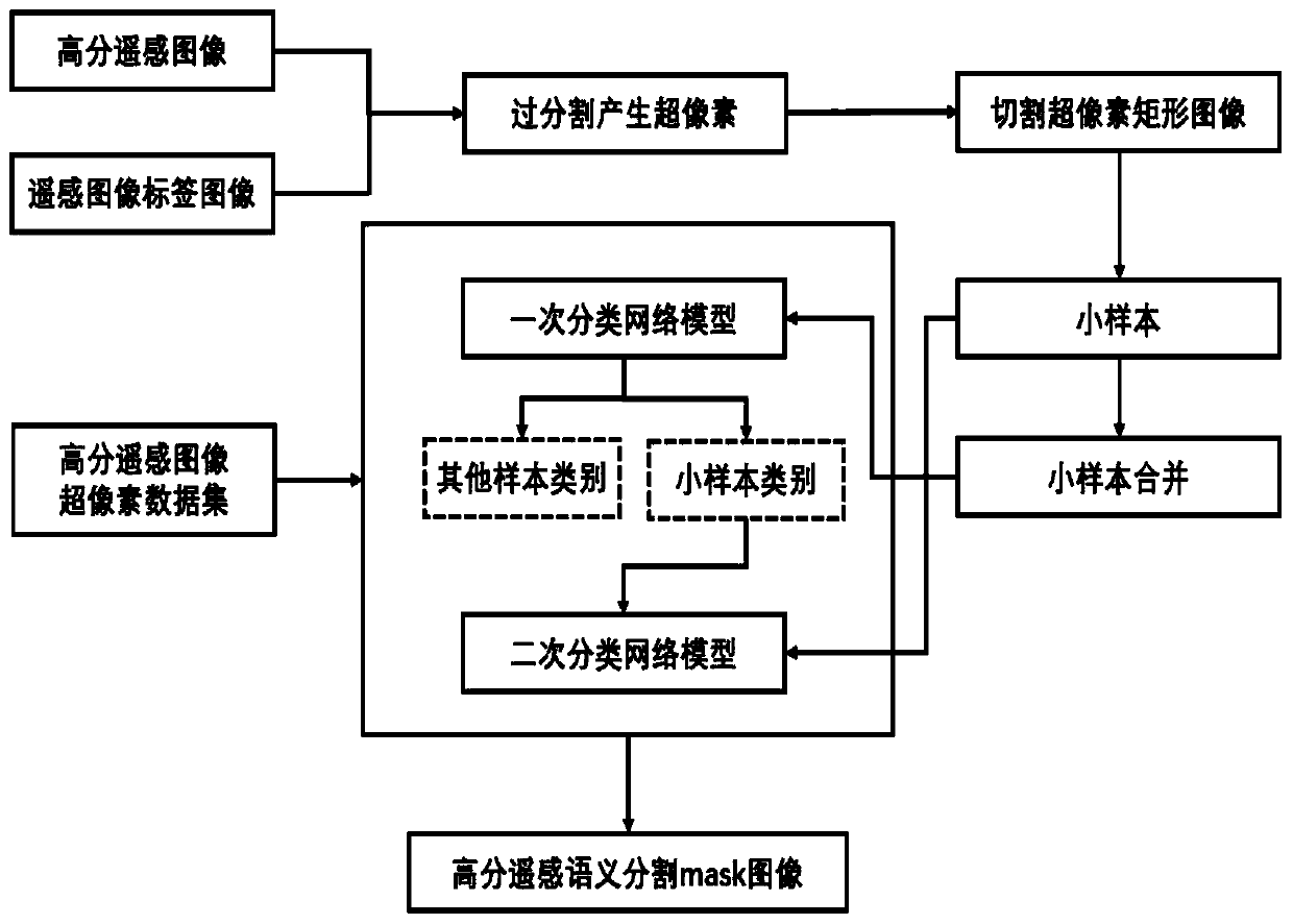
[0026] The embodiment includes the steps of image preprocessing, training an integrated classification model, performing superpixel segmentation on an image, generating a superpixel rectangular image, classifying the superpixel rectangular image, and mapping the classification result into a remote sensing image semantic image.

[0027] Step 1. Image data preprocessing

[0028] 1-1 First, the high-resolution remote sensing image is over-segmented to generate multiple superpixels.

[0029] 1-2 Then, centering on the center of gravity of the superpixel, cut out multiple superpixel rectangular images with a resolution of 32*32.

[0030] 1-3 Utilize the mapping relationship between the label map and superpixels, and use the category with the most pixels in the superpixels as the superpixel label, and divide the superpixels into 5 categories, including roads, water bodies, grasslands, and cultivated land , buildings, whose labels are 0, 1, 2, 3, 4, 5 respectively. The sample data ...


PUM


Abstract

The invention provides a super-pixel-based remote sensing image semantic segmentation method under a known sample imbalance condition, and the method comprises the steps: firstly carrying out the over-segmentation preprocessing of image data, obtaining a super-pixel segmentation result, cutting a rectangular image through employing the gravity center of each super-pixel as a central point, and constructing a super-pixel rectangular image data set; training an ensemble classification model, under the condition that the known samples are unbalanced, combining the small samples into one class, carrying out primary classification, carrying out secondary classification on the small samples after the primary classification is completed, and integrating the network models of the two classifications to obtain the ensemble classification model; inputting a to-be-predicted super-pixel rectangular image data set into the integrated classification network model to obtain a super-pixel rectangularimage category; and mapping the category of the super-pixel rectangular image to the original image to obtain a semantic segmentation result. According to the method, the semantic segmentation precision of the small sample under the condition that the known sample is unbalanced can be effectively improved finally.

Description

technical field [0001] The invention relates to computer image processing and Gaofen-2 satellite remote sensing image ground object classification technology. Background technique [0002] Remote sensing image interpretation is an important part of digital image analysis, widely used in land surveying and mapping, environmental monitoring, urban construction, mineral investigation, agricultural monitoring, military command and other fields. Through the acquisition, processing and analysis of remote sensing data, people can obtain a large amount of effective information in a short time and realize the dynamic monitoring of targets. Compared with traditional manual survey work methods, remote sensing technology has the advantages of high efficiency and low cost. [0003] Due to the development of deep learning, it has become a popular direction to use deep learning methods to directly extract ground feature information to achieve ground feature information segmentation and cl...

Claims


Application Information

Patent Timeline
Patent Type & Authority Applications(China)
IPC IPC(8): G06T7/11G06K9/62G06K9/00
CPCG06T7/11G06T2207/10032G06T2207/20081G06V20/13G06F18/24G06F18/214
Inventor 解梅梁佳雯胡希国汤诗雨徐小刚王士成李峰尚伟
Owner UNIV OF ELECTRONICS SCI & TECH OF CHINA
Why Eureka
Try Eureka