A Semantic Segmentation Method of Remote Sensing Image Based on Downsampling
A semantic segmentation and remote sensing image technology, applied in the field of remote sensing image semantic segmentation, can solve the problems of large amount of computation, many parameters, and low segmentation efficiency, and achieve the effect of improving segmentation accuracy
- Summary
- Abstract
- Description
- Claims
- Application Information
AI Technical Summary
Problems solved by technology
Method used
Image

Examples
Embodiment Construction
[0026] The data set used in the present invention comes from "The Fifth AIClassification and Recognition Competition:Challenge of AI on SatelliteImaging.Accessed:Oct.10,2017.[Online].Available:http: / / www.datafountain.cn / comp etitions / 270 / details?tdsourcetag=spctimaiomsg.), the image does not involve the interference of atmospheric light, cloud images and other factors, and no further processing is required. This dataset is a high-resolution image of a certain area in southern China in 2015 Remote sensing images, each image has five labels, namely vegetation, water, road, building and other classes, where land, woodland and grassland are defined as vegetation. There are 6 images in the dataset with dimensions ranging from 4 000 × 2 000 to 8 000 × 8 000 high-resolution remote sensing images of different sizes. The present invention uses 4 of them as training images and 2 as test images.
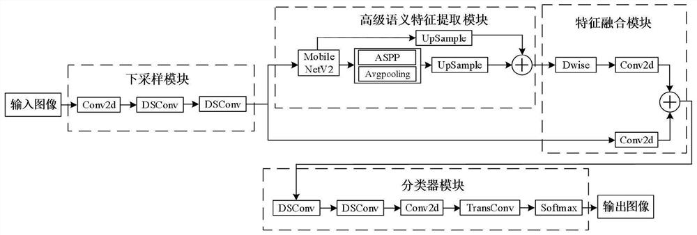
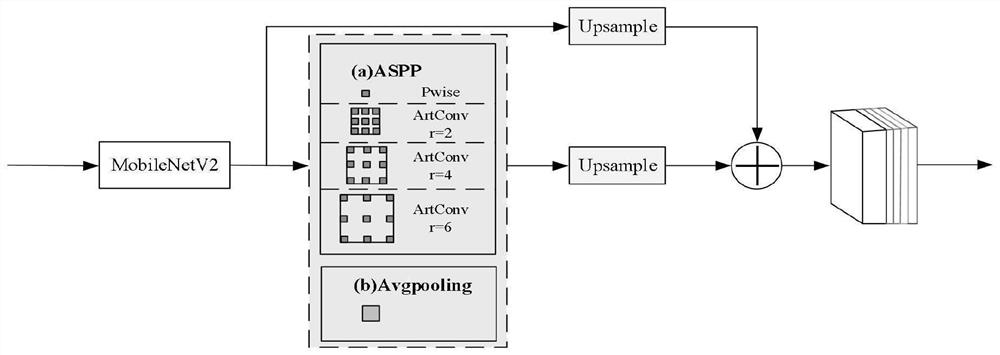
[0027] see figure 1 , figure 2 , image 3 , the present invention discloses a feature ...
PUM
 Abstract
Description
Claims
Application Information
 - R&D
- Intellectual Property
- Life Sciences
- Materials
- Tech Scout
- Unparalleled Data Quality
- Higher Quality Content
- 60% Fewer Hallucinations
Browse by: Latest US Patents, China's latest patents, Technical Efficacy Thesaurus, Application Domain, Technology Topic, Popular Technical Reports.
© 2025 PatSnap. All rights reserved.Legal|Privacy policy|Modern Slavery Act Transparency Statement|Sitemap|About US| Contact US: help@patsnap.com