Electronic map road attachment method and equipment

An electronic map and road technology, applied in the field of maps, can solve the problems of high error rate of road connection and low efficiency of road connection, and achieve the effect of high accuracy and high efficiency of road connection

Active Publication Date: 2022-06-03
NAVINFO
View PDF0 Cites 0 Cited by
  • Summary
  • Abstract
  • Description
  • Claims
  • Application Information

AI Technical Summary

Problems solved by technology

[0005] Embodiments of the present invention provide a method and device for linking roads on electronic maps to solve the technical problems in the prior art of low efficiency of linking roads and high error rate of linking roads due to manual linking of roads at intersections

Method used


Image

  • Electronic map road attachment method and equipment
  • Electronic map road attachment method and equipment
  • Electronic map road attachment method and equipment

Examples


Embodiment Construction

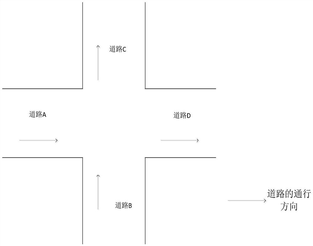
[0036] In the prior art, when the roads in the intersection are connected, for example, when the roads A, B, C in FIG. 1 are connected

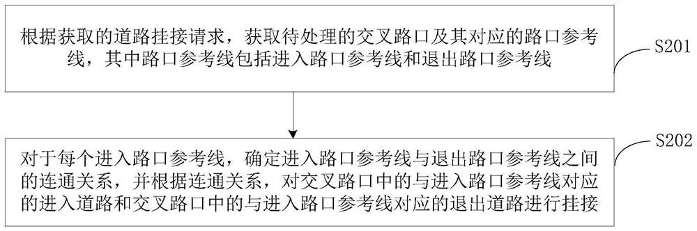
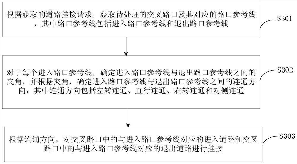
[0038] The technical scheme of the present invention is described in detail below with specific embodiments. The following specific implementations

[0048] Optionally, the connection relationship refers to a connection direction, which represents a road connection direction.

[0050] In addition, when the entry road and the exit road are automatically connected, the vehicle will actually enter the road and enter the vehicle.

[0057] Optionally, when performing frame selection, frame selection can be performed by selecting polygons.

[0059] If at least one does not support the articulation condition, it is determined that the intersection to be processed cannot be automatically articulated,

[0062] Specifically, the first preset number is 3 or 4.

[0066] When entering the intersection reference line and a certain exit intersection reference l...


PUM


Abstract

The present invention provides a method and device for linking roads on an electronic map. The method includes: acquiring the intersection to be processed and its corresponding intersection reference line according to the obtained road attachment request, wherein the intersection reference line includes entering the intersection reference line and exit intersection reference line; for each entry intersection reference line, determine the connection relationship between the entry intersection reference line and the exit intersection reference line, and according to the connection relationship, the The entry road corresponding to the reference line of the entry intersection and the exit road corresponding to the reference line of the entry intersection in the intersection are articulated to realize the automatic articulated road in the intersection, and the road articulated efficiency is high and accurate The rate is high, so that there will be no problems of low road connection efficiency and high road connection error rate caused by manual connection of roads at intersections.

Description

Electronic map road connection method and equipment technical field [0001] The embodiments of the present invention relate to the technical field of maps, and in particular, to a method and device for connecting a road to an electronic map. Background technique [0002] An intersection refers to a plane intersection, that is, a position where two or more roads intersect on the same plane, There are conflicts between traffic flows. When making a high-precision map, it is necessary to connect the roads in the intersection, and Roads in intersections to connect. [0003] In the prior art, in the high-precision map, when the road in the intersection is connected, it is generally the relevant personnel. It is to first determine the road entering the intersection and the road exiting the intersection in the intersection, and then check the relevant articulation regulations. Then, it is determined that the road entering the intersection and the road exiting the intersection ...

Claims


Application Information

Patent Timeline
Patent Type & Authority Patents(China)
IPC IPC(8): G01C21/32
CPCG01C21/32
Inventor 韩明靖
Owner NAVINFO
Why Eureka
Try Eureka