
A High Precision Image Navigation and Positioning Method Based on Local Neighborhood Map

A technology of navigation and positioning, local neighborhood, applied in the field of visual navigation, can solve the problem that the scale information SLAM positioning data is difficult to meet the needs of navigation and positioning, and cannot provide geographic coordinates.

Active Publication Date: 2022-02-22
NANJING UNIV OF AERONAUTICS & ASTRONAUTICS
View PDF5 Cites 0 Cited by
  • Summary
  • Abstract
  • Description
  • Claims
  • Application Information

AI Technical Summary

Problems solved by technology

In addition, from a principle point of view, the positioning error of the monocular SLAM system will gradually diverge with time. Even if the loop detection and fusion method is adopted, the degree of divergence can only be reduced to a certain extent.
In practical applications, SLAM positioning data lacking scale information and divergent errors are difficult to meet the needs of navigation and positioning
[0005] The autonomous navigation method based on visual SLAM can achieve high-precision local positioning, but cannot provide geographic coordinates in the earth coordinate system

Method used

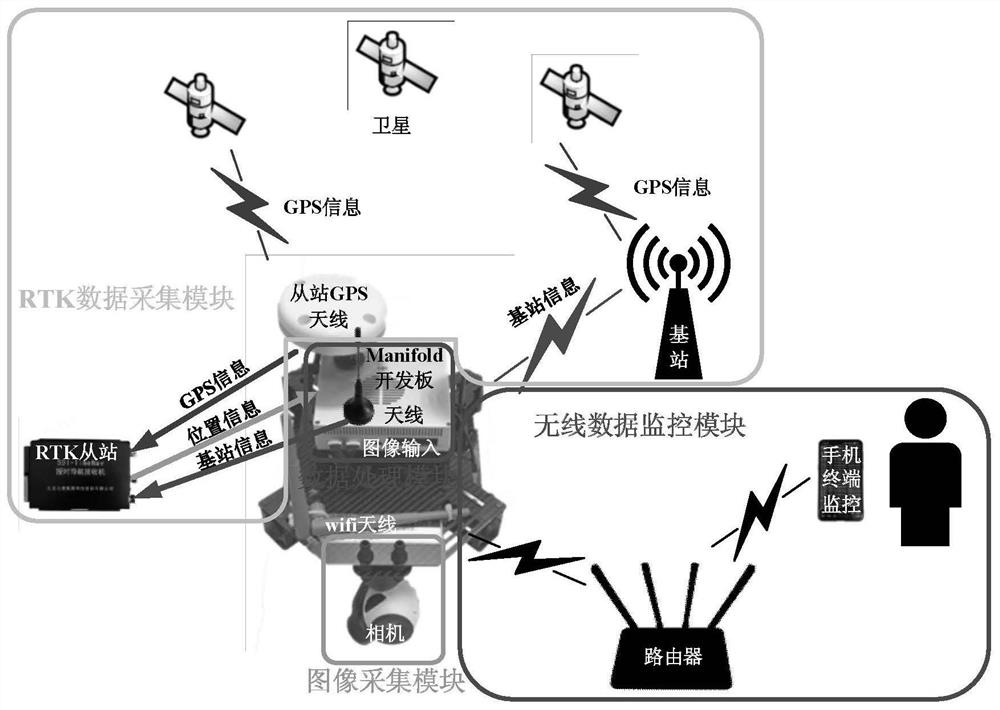
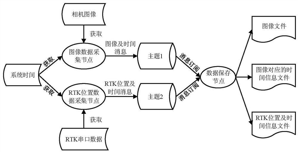
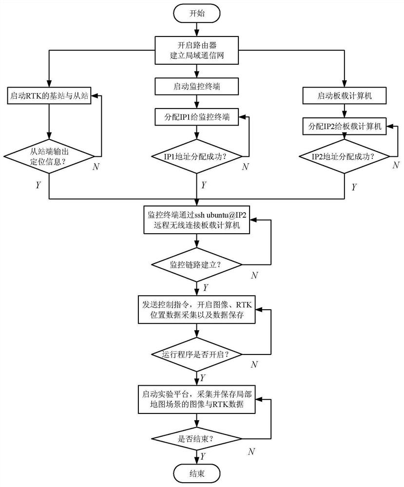

Image

  • A High Precision Image Navigation and Positioning Method Based on Local Neighborhood Map
  • A High Precision Image Navigation and Positioning Method Based on Local Neighborhood Map
  • A High Precision Image Navigation and Positioning Method Based on Local Neighborhood Map

Examples


Embodiment Construction

[0063] Below in conjunction with accompanying drawing, technical scheme of the present invention is described in further detail:

[0064] A high-precision image navigation and positioning method based on a local neighborhood map, which specifically includes the following two stages;

[0065] Phase 1: Offline map mapping phase:

[0066] Step 1.1: collect raw data;

[0067] Step 1.2: Establish a visual location figure 1 and geographically figure 2 ;

[0068] Step 1.3: Build a visual / geographical coordinate mapping table;

[0069] Phase 2: Navigation and positioning phase:

[0070] Step 2.1: Calculate the position of the current frame image in the visual coordinate system;

[0071] Step 2.2: The extracted neighborhood coordinate mapping table, such as Figure 5 shown;

[0072] Step 2.3: Calculate the parameters of the similar transformation model, and obtain the carrier position information from the parameters

[0073] 1. Offline map surveying stage

[0074] 1.1 Collec...


PUM


Abstract

The invention discloses a high-precision image navigation and positioning method based on a local neighborhood map, which belongs to the field of visual navigation, and specifically includes two stages: an offline map surveying and mapping stage and a navigation and positioning stage: specifically including: collecting original data; establishing a visual location map 1 and geographic location map 2; building a visual / geographical coordinate mapping table Step 4: Calculate the position of the current frame image in the visual coordinate system; extract the neighborhood coordinate mapping table; calculate similarity transformation model parameters, and obtain carrier position information from the parameters. The dynamic positioning accuracy of the decimeter level can be achieved. By establishing a navigation map offline and using the map to carry out online and real-time navigation and positioning of the carrier, the autonomous navigation and positioning of the vehicle can be realized only relying on images, and the dynamic positioning accuracy of the decimeter level can be achieved.

Description

technical field [0001] The invention belongs to the field of visual navigation, and in particular relates to a high-precision image navigation and positioning method based on a local neighborhood map. Background technique [0002] For wartime GPS signal denial environment, vehicle fully autonomous navigation mainly relies on traditional inertial navigation system. Due to the large cumulative error of long-term navigation and positioning of the inertial navigation system, it cannot be applied to the long-term high-precision navigation and positioning requirements, and it is necessary to seek a new fully autonomous navigation and positioning method. [0003] In recent years, visual SLAM has been widely used in drones, robots and other fields. It can complete map drawing and positioning in a local environment based on image sequences, and has a high degree of autonomy and high positioning accuracy. The parallel tracking and mapping (PTAM) algorithm proposed by the earliest et ...

Claims


Application Information

Patent Timeline
Patent Type & Authority Patents(China)
IPC IPC(8): G01C21/00G01C21/30G06T7/73
CPCG01C21/005G01C21/30G06T7/73G06T2207/10016
Inventor 赵科东孙永荣薛杨赵伟
Owner NANJING UNIV OF AERONAUTICS & ASTRONAUTICS
Learn More