Imaging wave position determination method based on sea-land target position information

A technology of target position and determination method, which is applied in measurement devices, radio wave measurement systems, and radio wave reflection/re-radiation, etc., and can solve the problems of fast flight speed, complex imaging wave position independent calculation, and large fluctuation of target altitude. Achieve the effect of high calculation accuracy and meet the needs of real-time monitoring and imaging

Active Publication Date: 2020-12-25
BEIJING INST OF SPACECRAFT SYST ENG
View PDF4 Cites 0 Cited by
  • Summary
  • Abstract
  • Description
  • Claims
  • Application Information

AI Technical Summary

Problems solved by technology

Since the spaceborne SAR has the characteristics of fast flight speed relative to the target, long distance between the satellite and the ground, and large fluctuations in the target altitude, the independent calculation of the imaging wave position of the spaceborne SAR is complicated, and there is no relevant discussion in domestic and foreign public documents or patents

Method used


Image

  • Imaging wave position determination method based on sea-land target position information
  • Imaging wave position determination method based on sea-land target position information
  • Imaging wave position determination method based on sea-land target position information

Examples


Embodiment Construction

[0035] In order to make the purpose, technical solutions and advantages of the present invention clearer, the implementation of the present invention will be further described in detail below in conjunction with the accompanying drawings.

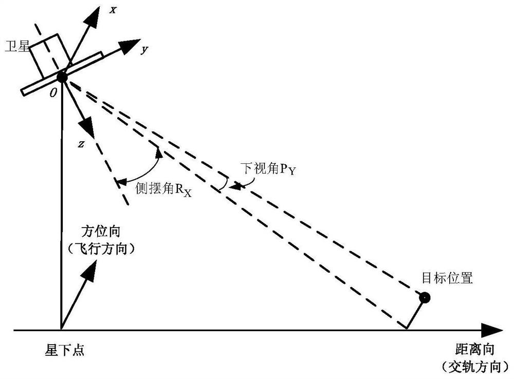
[0036] A method for determining imaging wave positions based on sea and land target position information, comprising the following steps:

[0037] Step 1: Prepare time t according to spaceborne SAR imaging pre , set the PVT data extrapolation time t of the satellite positioning system ex , t ex >t pre .

[0038] Step 2: t according to the WGS84 coordinate system ex Time satellite extrapolation position data P Sat,WGS84 and sea and land target (hereinafter referred to as target) position data P Tar,WGS84 , calculate the vector ΔP of the satellite pointing to the target in the WGS84 coordinate system Sat2Tar,WGS84 .

[0039] ΔP Sat2Tar,WGS84 =P Tar,WGS84 -P Sat,WGS84

[0040] Step 3: Calculate the transformation matrix L from the ...


PUM


Abstract

The invention discloses an imaging wave position determination method based on sea-land target position information, and belongs to a satellite-borne synthetic aperture radar imaging technology. The method comprises the following steps that firstly, PVT data extrapolation time of an on-satellite positioning system according to satellite-borne SAR imaging preparation time; secondly, based on PVT and attitude data broadcasted in real time, a position vector of a target under a satellite body coordinate system through coordinate system conversion and satellite-ground position calculation; and thirdly, an imaging moment and the optimal imaging wave position of the target are determined according to the position vector of the target under the satellite body coordinate system. According to the method, a PVT data extrapolation function of the on-satellite positioning system is fully utilized, input parameters are simple, satellite autonomous implementation is easy, and calculation precision is high.

Description

technical field [0001] The present invention relates to a method for determining the imaging wave position based on the location information of sea and land targets, in particular to a method for determining the imaging wave position of synthetic aperture radar based on the position information of sea and land targets, which belongs to the spaceborne synthetic aperture radar imaging technology. Background technique [0002] Spaceborne synthetic aperture radar (SAR) increasingly adopts active phased array antennas with variable viewing angle and variable beam. For different imaging widths and viewing angles, SAR is usually designed with different imaging wave positions. For specific sea and land target imaging tasks, the spaceborne SAR system needs to carry out mission planning in advance to determine the imaging wave positions required for target imaging. [0003] SAR satellite imaging mission planning is usually carried out with the assistance of ground personnel. According...

Claims


Application Information

Patent Timeline
Patent Type & Authority Applications(China)
IPC IPC(8): G01S13/90
CPCG01S13/90
Inventor 赵良波赵峭张庆君李延刘杰李海良周丽萍张驰
Owner BEIJING INST OF SPACECRAFT SYST ENG
Why Eureka
Try Eureka