Urban landscape classification optimization method and device, equipment and medium
An urban landscape and classification optimization technology, applied in the field of machine recognition, can solve the problems of reducing map accuracy, increasing the difficulty and workload of map drawing, and inaccurate remote sensing image classification, and achieving the effect of accurate recognition results and accurate classification.
Pending Publication Date: 2021-01-05
PEKING UNIV
0 Cites 1 Cited by
AI-Extracted Technical Summary
Problems solved by technology
[0003] However, the classification of existing remote sensing images is not accurate enough, and sometimes manual correct...
Method used
A kind of urban landscape classification and optimization method and device, equipment and medium that the embodiment of the present invention provides, by utilizing the functional area type feedback of identification to carry out readjustment identification to the land cover type of identification, thus make forward identification Combined with feedback adjustment, the recognition result is more accurate, and the land...
Abstract
The embodiment of the invention provides an urban landscape classification optimization method and device, equipment and a medium, and the method comprises the steps: S1, obtaining an urban landscaperemote sensing image, and recognizing a current land cover type based on the urban landscape remote sensing image; S2, obtaining a current spatial structure type corresponding to the urban landscape remote sensing image based on the current land cover type; S3, determining a current functional area type corresponding to the urban landscape remote sensing image based on the current spatial structure type; and S4, performing feedback adjustment on the current land cover type by utilizing the current functional area type to obtain a new current land cover type, and entering the step S2 until a preset stop condition is reached. According to the method, the identified land cover type is adjusted and identified again by utilizing the identified functional area type feedback, so that forward identification and feedback adjustment are combined, the identification result is more accurate, and landscapes in a city can be classified more accurately.
Application Domain
Character and pattern recognition
Technology Topic
Image basedEngineering +5
Image
Examples
- Experimental program(1)
Example Embodiment
[0050]In order to make the objectives, technical solutions, and advantages of the embodiments of the present invention clearer, the technical solutions in the embodiments of the present invention will be described clearly and completely in conjunction with the accompanying drawings in the embodiments of the present invention. Obviously, the described embodiments It is a part of the embodiments of the present invention, not all the embodiments. Based on the embodiments of the present invention, all other embodiments obtained by those of ordinary skill in the art without creative work shall fall within the protection scope of the present invention.
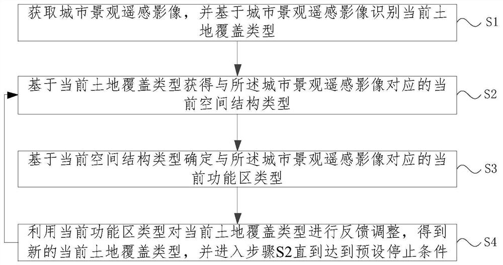
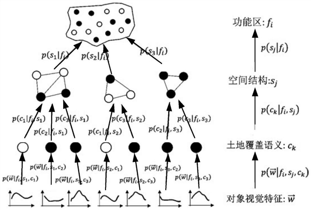
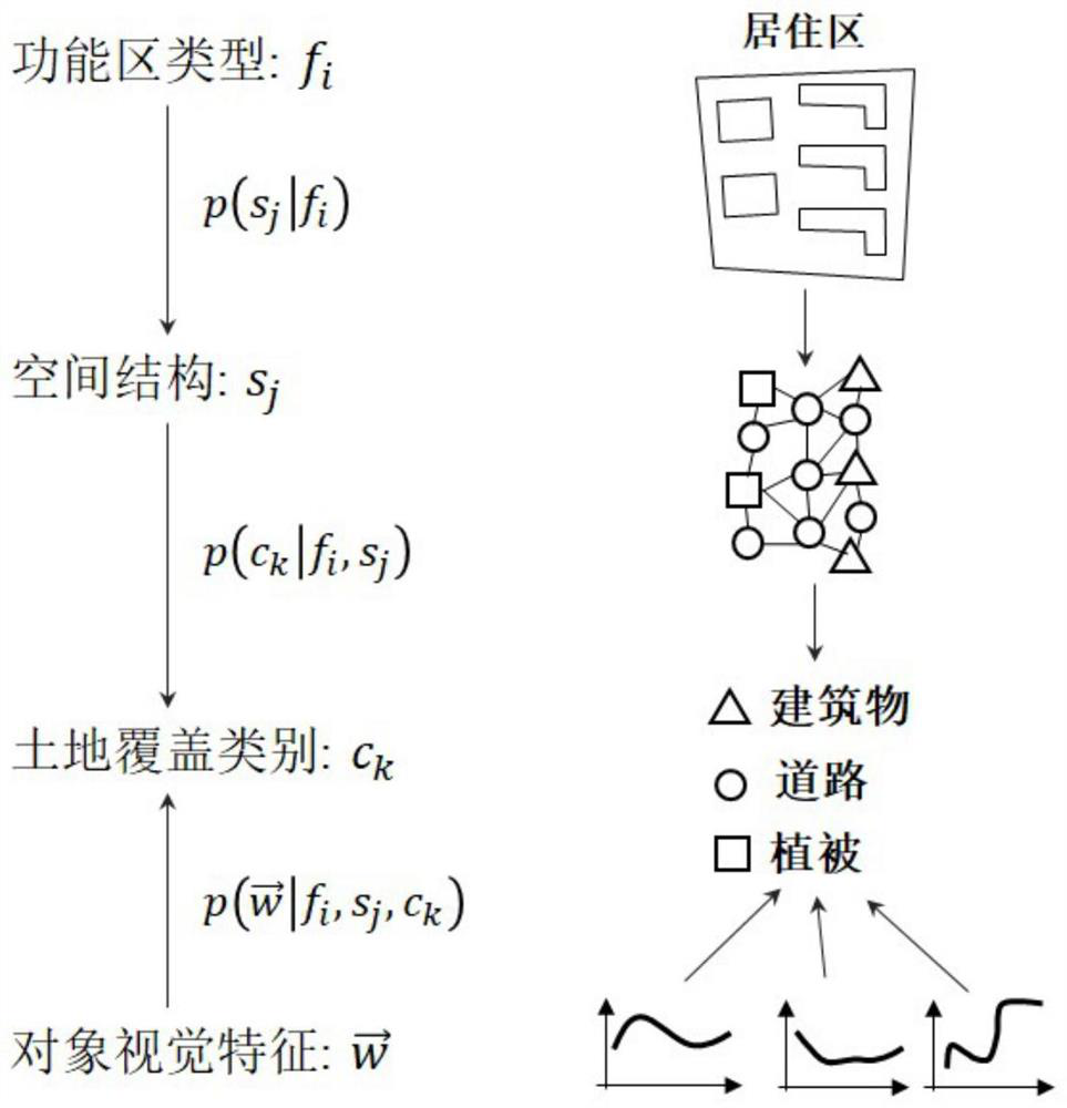
[0051]Combine belowFigure 1-Figure 3A method for optimizing urban landscape classification according to an embodiment of the present invention is described.figure 1 Is a flowchart of a method for optimizing urban landscape classification according to an embodiment of the present invention;figure 2 It is a schematic diagram of a hierarchical semantic cognitive model of a method for optimizing urban landscape classification according to an embodiment of the present invention;image 3 It is a schematic diagram of an inverse hierarchical semantic cognition model of an urban landscape classification optimization method provided by an embodiment of the present invention.
[0052]In a specific implementation manner of the present invention, an embodiment of the present invention provides a method for optimizing urban landscape classification, including:
[0053]S1: Obtain remote sensing images of urban landscapes, and identify current land cover types based on remote sensing images of urban landscapes;
[0054]Specifically, the following steps can be performed. First, the urban landscape remote sensing image can be obtained; specifically, the city map captured by satellite can be used as the urban landscape remote sensing influence, and then the urban landscape remote sensing image can be segmented to obtain the image object image; Feature extraction is performed on the image object image to obtain the object visual feature; based on the visual feature recognition, the current land cover type corresponding to the urban landscape remote sensing image is obtained. The visual features of the object include one or a combination of spectral features, texture features, geometric features, and color features.
[0055]More specifically, when performing object segmentation, perform noise reduction preprocessing on the collected remote sensing images to obtain denoised remote sensing images; perform grayscale processing and superpixel segmentation on the denoised remote sensing images; based on superpixels The segmentation results respectively extract texture features and color features; specifically include: based on the superpixel segmentation results, use the filtering method based on the total variation model to remove the texture to obtain the color feature, and use the Gabor filter to filter to obtain the texture feature; The processed remote sensing image is extracted with geometric features; the texture feature, color feature and geometric feature are fused to obtain image segmentation features; based on the image segmentation feature, the mean shift is used for image filtering to obtain the preliminary segmentation results; the preliminary segmentation results are merged , Get the final segmentation result, that is, affect the target image.
[0056]S2: Obtain the current spatial structure type corresponding to the urban landscape remote sensing image based on the current land cover type;
[0057]After obtaining the current land cover type, the corresponding current spatial structure type can be obtained according to the land cover type. Specifically, perform density clustering on the current land cover type to obtain the function value of the density cluster G function; determine the current spatial structure type corresponding to the urban landscape remote sensing image according to the corresponding relationship between the function value and the spatial structure type.
[0058]In other words, classical object-oriented remote sensing image technology can be used to classify the visual features and land cover categories of objects. The spatial structure type is used to measure the spatial relationship between land cover objects. In each scene, the objects are represented by the centroid, and the spatial relationship is measured by the centroid distance, so their spatial structure can be characterized by the G function. The G function measures the cumulative distribution of the nearest neighbor distances between objects, where the nearest neighbor distance refers to the distance from an object to its nearest neighbor. The G function can measure aggregation, random distribution and uniform distribution patterns. However, G-curves are not directly used to represent the patterns of space objects because they are easily affected by the results of land cover misclassification. Therefore, the density clustering method is based on G-function clustering to obtain different spatial structure types. Furthermore, a hierarchical semantic cognition model can be constructed to express the visual features, land cover categories and spatial structure types of objects hierarchically to identify the types of functional areas.
[0059]S3: Determine the current functional area type corresponding to the urban landscape remote sensing image based on the current spatial structure type;
[0060]After knowing the current spatial structure type, the corresponding relationship between the existing spatial structure type and the functional area type can be used to determine the current functional area type. Of course, if the type of space structure is determined in time, the type of functional area cannot be determined, but there is a probability relationship between the two, which can basically determine the type of current functional area.
[0061]S4: Use the current functional area type to feedback and adjust the current land cover type to obtain the new current land cover type, and proceed to step S2 until the preset stop condition is reached.
[0062]After the functional area type is determined, the functional area type can be used to make feedback adjustments to the previous current land cover type. At this time, because there are some ambiguities in the identification of land cover types, misjudgments may occur. After the functional area type is determined, the land cover type can be reversed according to the functional area type to achieve land cover The type is more precise and accurate identification and confirmation.
[0063]For example, for land cover classification, functional area types can provide local contextual information, which can be used as a constraint to supplement remote sensing image features to achieve land cover classification. For example, if the image feature of an object is dark and rectangular, the object may belong to a building or a body of water, but considering that the functional area type is "shantytown", it can be inferred to be a building. This process uses high-level functional area information to calibrate the low-level land cover category, so it is called "top-down feedback optimization." The two processes of bottom-up classification and top-down feedback are performed alternately, or even simultaneously, so that land cover types and functional area types can be accurately identified.
[0064]Compared with the prior art, the urban landscape classification optimization method provided by the embodiments of the present invention mainly focuses on the bottom-up recognition method of land cover and functional area classification, but ignores the top-down feedback. For land cover classification, many techniques have been developed in the past few decades, and they are mainly divided into two types: pixel-by-pixel classification and object-based classification. In the early stages, pixel-by-pixel classification was popular, and many classifiers were developed, such as artificial neural networks, decision trees, K-nearest neighbors, support vector machines, and random forests. These methods are good at classifying the land cover of low-resolution satellite images based on image characteristics, but the accuracy is low when processing high-resolution remote sensing images because the land cover in these images is heterogeneous. In order to solve this problem, an object-based classification method is proposed. Firstly, the image is segmented into similar objects, then the object features are classified, and finally the land cover classification of these objects is performed according to the features. Object-based methods can greatly reduce the spectral heterogeneity of high-resolution remote sensing images and classify more complete land cover.
[0065]In fact, the bottom-up classification mechanism based on pixel and object classification, because they only use low-level image features to obtain high-level land cover categories; furthermore, these methods ignore top-down feedback, so they cannot be further improved Classification results. The classification of functional areas is usually implemented based on high-resolution remote sensing images using scene-based classification, where functional areas are represented by image scenes. In the early days, scene classification was based on visual features, such as spectrum, texture, and geometric features, and was classified by traditional classifiers. These methods are effective for processing simple scenes with special visual signs, but they cannot classify heterogeneous scenes containing various ground objects and non-stationary visual features. However, these scene classification methods are completely dependent on low-level feature information and belong to bottom-up classification, and their results are usually affected by inaccurate low-level information. Therefore, top-down feedback should be considered to optimize land cover and further improve the results of functional area classification.
[0066]In the embodiment of the present invention, the feedback adjustment of the functional area type to the land cover type is introduced for the first time, so that the identification of the land cover type is more accurate. No manual correction is required, which greatly reduces the difficulty and workload of map drawing, and also improves the accuracy of the map.
[0067]Further, on the basis of the above-mentioned embodiments, the embodiment of the present invention focuses on how to determine the current functional area type. Specifically, firstly, after obtaining the target remote sensing image object using the image segmentation method, based on the visual characteristics of the remote sensing image Classify and identify the types of land cover; classify the spatial structure of features based on the classification results of land cover; define the hierarchical semantic cognitive model based on image features, land cover categories, and spatial structure to identify functional area types; thus, the hierarchical semantic cognitive model can be used to perform Recognition of the type of functional area.
[0068]Specifically,figure 2 Is a schematic diagram of a hierarchical semantic cognitive model provided by an embodiment of the present invention, such asfigure 2 As shown, the modeling idea of the hierarchical semantic cognitive model is to organize visual features, object semantic features, and spatial pattern features hierarchically, and express their hierarchical dependence in the form of conditional probability of functional areas. The research in this chapter involves four levels of features, including object visual features, land cover, spatial structure, and functional areas. among them:
[0069]Object visual feature layer: each object can be a visual feature Expressed, It consists of N features, including spectrum, texture, and geometric features. These features are the key to identifying the target land cover semantics; land cover semantics: consider K types of land cover, of which the kth type is denoted as ck(1≤k≤K); Object spatial structure layer: Digitally measure the spatial structure of objects, and cluster these spatial structures. A total of J clusters are generated, sj(1≤j≤J) represents the j-th cluster; functional area category layer: consider M functional area types, fi(1≤i≤M) represents the i-th category; in addition, the functional area to be classified is marked as z.
[0070]The hierarchical semantic cognitive model is essentially a three-layer Bayesian model, where each layer represents the dependency between two semantic layers. First, the first layer represents the relationship between the object space structure and the type of functional area. E.gfigure 2 In, p(sj|fi) Represents the spatial structure sjAppears in fiThe probability in the functional area. In this figure, there are three land cover objects appearing in fi, The probability of occurrence is expressed as p(s1|fi), p(s2|fi) And p(s3|fi). Second, p(ck|fi,sj) Models the relationship between the spatial structure of the object and the semantics of the land cover object. Take p(c1|fi,s1) As an example, it is expressed in fiMiddle, c1Class land cover appears in s1Probability in the structure. For different spatial structures, the probability distribution of land cover semantics is usually different. third, Means ckThe probability distribution of the feature. In the same spatial pattern, different land cover objects usually have different characteristic distributions, for example: with However, in different object spatial structures, the feature distribution of the same land cover object is also slightly different, such as with Therefore, the hierarchical semantic cognitive model comprehensively considers and expresses the above information. According to the probability formula, it can be determined that the urban landscape remote sensing image z belongs to the functional area type fiThe probability value p(fi|z); According to the probability value p(fi|z) Determine the corresponding current functional area type.
[0071]Assuming that each functional area is actually a combination of different categories, therefore, visual features can be expressed as linear combinations of different categories:
[0072]
[0073]Where p(fi|z) indicates that the scene z belongs to the functional area category fiIn order to calculate p(fi|z), first calculate another parameter Means fiIt is very difficult to estimate the probability distribution of visual features in fiMedium is usually variable and non-stationary. For example infigure 2 Middle, fiIt is composed of multiple spatial structures, and the probability distribution of visual features in each spatial structure is different. therefore, It is confusing and should be decomposed according to different spatial structures:
[0074]
[0075]Where p(sj|fi) Means fiMiddle sjProbability of occurrence, Means fiMiddle sjVisual characteristics. however, It is still confusing, because in a spatial object structure, different types of land cover objects usually have different visual characteristics. Therefore, further decompose it:
[0076]
[0077]Where p(ck|fi,sj) Means sjMiddle ckThe frequency distribution. Is ckThe visual characteristics of it are relatively pure and have low variability. Therefore, combining all the above formulas Can be broken down into:
[0078]
[0079]In addition, There is another way of expression:
[0080]
[0081]Where p(sj|z) indicates that the spatial structure of the object in the scene z to be classified belongs to sjProbability, p(ck|sj,z) is ckFrequency of appearance, its characteristics are expressed as To be precise, z has only one object space structure, which is defined as st(1≤t≤J), obviously when j≠t, p(sj|z)=0. Therefore, the above formula can be simplified as:
[0082]
[0083]By combining the above formulas, a hierarchical semantic cognitive model can be defined, which represents the relationship between the scene to be classified and different types of functional areas. In the hierarchical semantic cognitive model, p(fi|z) determines that the classification result of z is a parameter to be sought, and other parameters can be obtained through data statistics. The hierarchical semantic cognition model organizes the features on the four semantic levels through a hierarchical method, and expresses the relationship between them in a functional area conditional probability method:
[0084]
[0085]among them, Is the visual feature of the object; ckIs the kth land cover type, ck(1≤k≤K), K is a positive integer; sjIs the spatial structure type sj(1≤j≤J); fi(1≤i≤M) represents the i-th functional area type; z is the functional area to be classified in the urban landscape remote sensing image; Is the visual feature of the object in scene z Frequency distribution; For fiVisual features of objects in the ribbon The probability distribution of; p(z) is the probability of appearance of the urban landscape remote sensing image z, which is a constant; Means fiThe probability distribution of the visual features of the medium object, p(sj|fi) Means fiMiddle sjProbability of occurrence, Means fiMiddle sjProbability of appearance of visual features; p(ck|fi,sj) Means sjMiddle ckFrequency distribution; Is ckProbability of appearance of visual features.
[0086]The urban landscape classification optimization method provided by the embodiment of the present invention performs iterative optimization classification of land cover and functional areas by defining a hierarchical semantic cognitive model and an inverse hierarchical semantic cognitive model, combining bottom-up classification and top-down feedback , And the results are applied to land cover and functional area mapping based on remote sensing images.
[0087]Specifically,image 3 It is a schematic diagram of an inverse hierarchical semantic cognitive model provided by an embodiment of the present invention, such asimage 3 As shown, the modeling idea of the inverse hierarchical semantic cognition model is to organize the preliminary classification results, spatial structure and image features of functional areas hierarchically, and express the relationship between the three and land cover in the form of conditional probability of functional areas. The research in this chapter involves four levels, including object visual characteristics, land cover, spatial structure, and functional areas. The mathematical expressions at each level are consistent with those in the hierarchical semantic cognitive model.
[0088]The inverse hierarchical semantic cognition model is a top-down mathematical model of feedback (that is, the feedback is regressed from the functional area type of the recognition result). It has a similar hierarchical structure to the hierarchical semantic cognition model, but the cognitive process is opposite. The inverse hierarchical semantic cognitive model essentially uses the area category as a priori information to optimize the land cover classification, so it has a different mathematical representation from the hierarchical semantic cognitive model. For the object O in the functional area, its characteristic is It belongs to the spatial structure st, So it belongs to different land cover category ckThe probability of (1≤k≤K) can be expressed as Inverse hierarchical semantic cognitive model for computing
[0089]
[0090]Where p(ck|st,z) stands for ckThe proportion of similar land cover in scene z, Means ckThe probability distribution of the visual features of the objects in the land cover category, these two parameters can be obtained through statistics. In addition, Is a parameter in the hierarchical semantic cognitive model, which can be calculated by the following formula:
[0091]
[0092]Where p(st|z), p(sj|fi), And p(cn|fi,sj) Is consistent with the meaning in the hierarchical semantic cognitive model, while p(fi|z) can be calculated by the hierarchical semantic cognitive model. By combining the above formulas, an inverse hierarchical semantic cognitive model can be constructed for computing
[0093]
[0094]The inverse hierarchical semantic cognitive model not only uses visual features, but also uses top-down information (including functional area categories and spatial structure) to classify land cover, so it can generate more accurate classification results. The inverse hierarchical semantic cognitive model is the first mathematical model that can use top-down feedback for land cover classification.
[0095]The urban landscape iterative optimization classification method provided by the embodiment of the present invention performs iterative optimization of land cover and functional areas by defining a hierarchical semantic cognitive model and an inverse hierarchical semantic cognitive model, combined with bottom-up classification and top-down feedback Classification, and the results are applied to land cover and functional area mapping based on remote sensing images.
[0096]In other words, if you want to calculate the probability of the current land cover type according to the feedback probability formula, get the probability result: re-determine the new current land cover type according to the probability result; the feedback probability formula is as follows, and the specific principle is as described above. I won’t repeat them one by one here:
[0097]
[0098]among them, Is the visual feature of the object, Composed of N features, including spectrum, texture, and geometric features; ckIs the kth land cover type, ck(1≤k≤K), K is a positive integer; sjIs the spatial structure type sj(1≤j≤J); fi(1≤i≤M) represents the i-th functional area type; z is the functional area to be classified in the urban landscape remote sensing image; For the current land belongs to land cover category ck(1≤k≤K) probability; p(ck|st,z) stands for ckThe proportion of similar land cover in scene z; CkThe probability distribution of the visual features of the objects in the land cover category; p(st|z) is stThe probability value belonging to z; p(fi|z) is a remote sensing image of urban landscape z belongs to functional area type fiThe probability value; Is cnProbability of appearance of visual features; p(cn|fi,sj) Means sjMiddle cnThe frequency distribution.
[0099]On the basis of the foregoing embodiment, the preset stopping conditions are described in this embodiment. The preset stopping conditions include: reaching the preset number of cycles; or the current land cover type has not changed compared with the new current land cover type. In other words, the number of cycles can be set to positive integers such as 1, 2, 3..., so as to achieve a preset number of cycles. Of course, the current land cover type can also be compared with the newly generated current land cover type. If there is no change, it means that there is no need to continue the cycle. Even if the cycle is repeated, the results obtained will not change.
[0100]The following describes the urban landscape classification and optimization device provided by the embodiment of the present invention. The urban landscape classification optimization device described below and the urban landscape classification optimization method described above can be referred to each other.
[0101]Please refer toFigure 4 ,Figure 4 A schematic diagram of the composition of a device for optimizing urban landscape classification is provided for an embodiment of the present invention.
[0102]In another specific implementation manner of the UEFA Champions League, an embodiment of the present invention provides an urban landscape classification and optimization device 400, including:
[0103]The land type identification module 410 is used to obtain remote sensing images of urban landscapes, and to identify the current land cover types based on the remote sensing images of urban landscapes;
[0104]The spatial type obtaining module 420 is configured to obtain the current spatial structure type corresponding to the urban landscape remote sensing image based on the current land cover type;
[0105]The function type determining module 430 is configured to determine the current function area type corresponding to the urban landscape remote sensing image based on the current spatial structure type;
[0106]The cyclic adjustment module 440 is configured to feedback and adjust the current land cover type using the current functional area type to obtain a new current land cover type, and trigger the space type obtaining module until the preset stop condition is reached.
[0107]An urban landscape classification optimization method, device, equipment, and medium provided by the embodiment of the present invention re-adjust and recognize the recognized land cover type by using the recognized functional area type feedback, thereby enabling positive recognition and feedback adjustment Combined, the recognition result is more accurate, and the landscape in the city can be classified more accurately.
[0108]Figure 5 An example of a physical structure diagram of an electronic device, such asFigure 5 As shown, the electronic device may include: a processor (processor) 510, a communication interface (Communications Interface) 520, a memory (memory) 530, and a communication bus 540. The processor 510, the communication interface 520, and the memory 530 pass through the communication bus 540. Complete mutual communication. The processor 510 can call the logic instructions in the memory 530 to execute a method for optimizing urban landscape classification. The method includes S1: acquiring urban landscape remote sensing images, and identifying the current land cover type based on the urban landscape remote sensing images; S2: based on the current land The coverage type obtains the current spatial structure type corresponding to the urban landscape remote sensing image; S3: Determine the current functional area type corresponding to the urban landscape remote sensing image based on the current spatial structure type; S4: Use the current functional area type to cover the current land Type feedback adjustment to obtain the new current land cover type, and proceed to step S2 until the preset stop condition is reached.
[0109]In addition, the aforementioned logic instructions in the memory 530 can be implemented in the form of a software functional unit and when sold or used as an independent product, they can be stored in a computer readable storage medium. Based on this understanding, the technical solution of the present invention essentially or the part that contributes to the existing technology or the part of the technical solution can be embodied in the form of a software product, and the computer software product is stored in a storage medium, including Several instructions are used to make a computer device (which may be a personal computer, a server, or a network device, etc.) execute all or part of the steps of the methods described in the various embodiments of the present invention. The aforementioned storage media include: U disk, mobile hard disk, read-only memory (ROM, Read-Only Memory), random access memory (RAM, Random Access Memory), magnetic disks or optical disks and other media that can store program codes. .
[0110]On the other hand, the embodiments of the present invention also provide a non-transitory computer-readable storage medium on which a computer program is stored. The computer program is implemented when executed by a processor to perform the urban landscape classification provided by the foregoing embodiments. Optimization method, the method includes S1: Obtaining urban landscape remote sensing image, and identifying the current land cover type based on the urban landscape remote sensing image; S2: Obtaining the current spatial structure type corresponding to the urban landscape remote sensing image based on the current land cover type; S3: Determine the current functional area type corresponding to the urban landscape remote sensing image based on the current spatial structure type; S4: Use the current functional area type to feedback and adjust the current land cover type to obtain the new current land cover type, and proceed to step S2 until reaching Preset stop conditions.
[0111]The device embodiments described above are merely illustrative. The units described as separate components may or may not be physically separated, and the components displayed as units may or may not be physical units, that is, they may be located in One place, or it can be distributed to multiple network units. Some or all of the modules may be selected according to actual needs to achieve the objectives of the solutions of the embodiments. Those of ordinary skill in the art can understand and implement it without creative work.
[0112]Through the description of the above implementation manners, those skilled in the art can clearly understand that each implementation manner can be implemented by software plus a necessary general hardware platform, and of course, it can also be implemented by hardware. Based on this understanding, the above technical solution essentially or the part that contributes to the existing technology can be embodied in the form of a software product, and the computer software product can be stored in a computer-readable storage medium, such as ROM/RAM, magnetic A disc, an optical disc, etc., include a number of instructions to make a computer device (which may be a personal computer, a server, or a network device, etc.) execute the methods described in each embodiment or some parts of the embodiment.
[0113]Finally, it should be noted that the above embodiments are only used to illustrate the technical solutions of the present invention, not to limit it; although the present invention has been described in detail with reference to the foregoing embodiments, those of ordinary skill in the art should understand that: The technical solutions recorded in the foregoing embodiments are modified, or some of the technical features are equivalently replaced; these modifications or replacements do not cause the essence of the corresponding technical solutions to deviate from the spirit and scope of the technical solutions of the embodiments of the present invention.
PUM


Description & Claims & Application Information
We can also present the details of the Description, Claims and Application information to help users get a comprehensive understanding of the technical details of the patent, such as background art, summary of invention, brief description of drawings, description of embodiments, and other original content. On the other hand, users can also determine the specific scope of protection of the technology through the list of claims; as well as understand the changes in the life cycle of the technology with the presentation of the patent timeline. Login to view more.
Similar technology patents
Signal processing method, electronic equipment and storage medium
PendingCN114330409AThe recognition result is accurate
Owner:GUANGZHOU HUIRUI SITONG INFORMATION SCI & TECH CO LTD
Packaging printing abnormity monitoring method based on artificial intelligence
ActiveCN114841998AThe recognition result is accurateSolve the inaccurate test results
Owner:山东嘉路包装科技有限公司
Goods selling method and device, goods selling cabinet and medium
ActiveCN114445958AThe recognition result is accurate
Owner:湖南云数信息科技有限公司
Spoken language evaluation method and device based on phonemes and electronic equipment
ActiveCN112863486AThe recognition result is accurateGood phoneme alignment
Owner:北京一起教育科技有限责任公司
Age recognition method and device and electronic equipment
Owner:GUANGZHOU BAIGUOYUAN INFORMATION TECH CO LTD
Classification and recommendation of technical efficacy words
- accurate classification
- The recognition result is accurate
Artificial intelligence arithmetic system for fund investment and financing
InactiveCN108921706Aaccurate classification
Owner:上海中欧财富基金销售有限公司
Network intrusion detection method based on generative adversarial network oversampling
Owner:JIANGXI NORMAL UNIVERSITY
Acoustic image texture feature extraction method based on multi-scale blurring
Owner:HARBIN ENG UNIV
Video classification method and device
ActiveCN109710802Aaccurate classification
Owner:BAIDU ONLINE NETWORK TECH (BEIJIBG) CO LTD
Method for generating target detection football candidate point of Nao robot based on Heatmap
Owner:TONGJI ARTIFICIAL INTELLIGENCE RES INST SUZHOU CO LTD
Fraud number identification method and system based on convolutional neural network
PendingCN111222025AThe recognition result is accurate
Owner:南京中新赛克科技有限责任公司
Age recognition method and device and electronic equipment
Owner:GUANGZHOU BAIGUOYUAN INFORMATION TECH CO LTD
Goods selling method and device, goods selling cabinet and medium
ActiveCN114445958AThe recognition result is accurate
Owner:湖南云数信息科技有限公司
Spoken language evaluation method and device based on phonemes and electronic equipment
ActiveCN112863486AThe recognition result is accurateGood phoneme alignment
Owner:北京一起教育科技有限责任公司