Remote sensing inversion of winter wheat evapotranspiration and assimilation method with crop model

A technology of remote sensing inversion and winter wheat, applied in character and pattern recognition, image enhancement, instruments, etc., can solve the problems of large manpower, financial and material resources, poor data accuracy, and difficulty in wide-scale application, achieving strong timeliness, Improving accuracy and overcoming the effect of poor accessibility

Active Publication Date: 2022-06-03
HENAN INST OF METEOROLOGICAL SCI
View PDF12 Cites 0 Cited by
  • Summary
  • Abstract
  • Description
  • Claims
  • Application Information

AI Technical Summary

Problems solved by technology

[0003] At present, the traditional way to obtain evapotranspiration is to use evapotranspiration point measurement data to estimate through meteorological data and crop coefficients, mainly including lysimeter method, eddy coherence instrument and other methods. These methods not only consume a lot of manpower, financial and material resources , and it takes a long time, it is difficult to apply it on a large scale, and the data acquisition is only limited to the point scale, and the point-scale evapotranspiration data is extended to the regional scale evapotranspiration calculation, and the accuracy of the obtained data is poor

Method used


Image

  • Remote sensing inversion of winter wheat evapotranspiration and assimilation method with crop model
  • Remote sensing inversion of winter wheat evapotranspiration and assimilation method with crop model
  • Remote sensing inversion of winter wheat evapotranspiration and assimilation method with crop model

Examples


Embodiment Construction

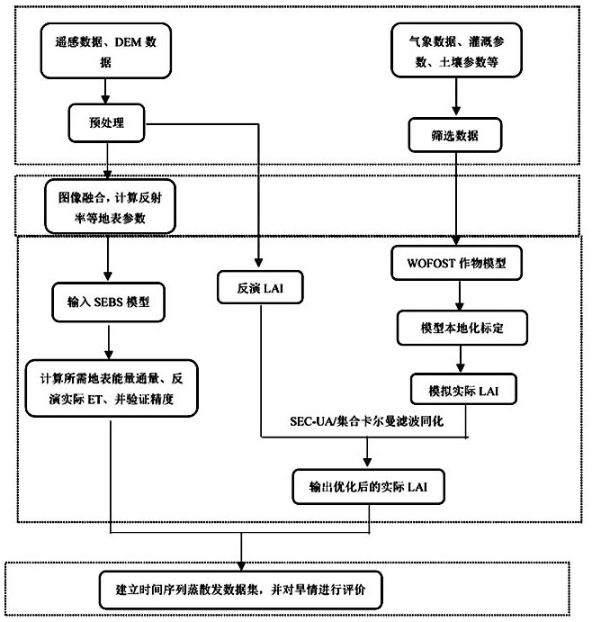
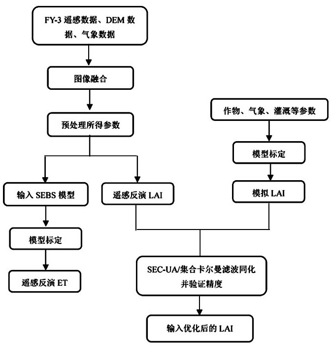
[0068] Since remote sensing images are often disturbed by clouds, the inversion accuracy is affected.

[0069]

[0072] For the Surface Energy Balance (SEBS) model and the WOFOST model, the "regionalization" and "localization" of the model are

[0074]

[0075] The influence of a single parameter and each parameter on each other is regarded as the total variance of the model:

[0076]

[0078]

[0084]

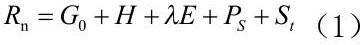
[0085] This formula does not consider the energy transfer transfer in the horizontal direction, in the formula: represents the surface net radiation flux, W / m²;

[0086]

[0088]

[0090]

[0093]

[0096]

[0098]

[0100] Using remote sensing data assimilation with model simulation values, large-area observations can be assimilated. Retrieving evapotranspiration from remote sensing

[0102]

[0105]


PUM


Abstract

The invention discloses a winter wheat evapotranspiration remote sensing inversion and crop model assimilation method. By collecting data and calculating and analyzing the data through technical means, the disadvantages of time-consuming, labor-intensive and economical consumption of traditional methods can be effectively overcome. It provides a reliable basis for yield estimation, drought monitoring, and rational use of irrigation water; it has the advantage of strong timeliness, and can observe large areas simultaneously, effectively overcoming the shortcomings of poor accessibility in traditional surveys; it solves the bottleneck of difficult acquisition of regional parameters, remote sensing information Combining with the crop model can achieve the purpose of optimizing the inversion of evapotranspiration and drought monitoring; combining the remote sensing inversion of evapotranspiration with the crop model to output assimilated evapotranspiration can not only improve the accuracy of remote sensing inversion of evapotranspiration, but also output time-continuous evapotranspiration information Combination of multi-source remote sensing data; coupling of SEBS model inversion ET and crop growth model, output of improved ET and LAI, combined with PET for daily dynamic drought monitoring of winter wheat, forming business service capabilities.

Description

Remote sensing retrieval of winter wheat evapotranspiration and assimilation with crop model technical field The present invention relates to winter wheat field drought monitoring method, especially relate to winter wheat evapotranspiration remote sensing inversion and crop Model assimilation method. Background technique As a big agricultural country in my country, whether agricultural water resources are sufficient is related to food security and national stability. Agricultural water consumption in many regions accounts for 70% of the total water consumption, therefore, effectively improving the utilization efficiency of agricultural water can effectively alleviate the The current situation of the shortage of water resources in the region, and in-depth study of the water consumption law of crops and timely understanding of the drought conditions of crops is to improve the A prerequisite for agricultural water use efficiency. Evapotranspiration (English: Evapotrans...

Claims


Application Information

Patent Timeline
Patent Type & Authority Patents(China)
IPC IPC(8): G06T5/50G06V20/13
CPCG06T5/50G06T2207/10032G06T2207/20221G06T2207/30188G06V20/188Y02A90/10
Inventor 李颖陈怀亮梁辰史丽晨王睿李进学
Owner HENAN INST OF METEOROLOGICAL SCI
Why Eureka
Try Eureka