Multi-source navigation enhancement method suitable for complex flight of unmanned aerial vehicle in low-altitude airspace

A UAV and airspace technology, which is used in navigation, navigation, mapping and navigation through speed/acceleration measurement, which can solve the problems of radio navigation safety hazards, great difficulty and cost, and poor radio anti-interference, so as to improve the airspace. Traffic and control efficiency, make up for performance degradation, and improve the effect of navigation accuracy

Active Publication Date: 2021-09-03
BEIHANG UNIV
View PDF5 Cites 1 Cited by
  • Summary
  • Abstract
  • Description
  • Claims
  • Application Information

AI Technical Summary

Problems solved by technology

However, there are two significant disadvantages in radio navigation, which is difficult to meet the full-scenario and high-reliability requirements of high-density low-altitude airspace management in the future.
Due to the poor anti-jamming performance of radio, the rapid development of electronic countermeasure technology makes radio navigation a great security risk in the military and civilian fields; at the same time, the existing methods have a strong dependence on navigation beacons, and when restricted by urban high-rise buildings and canyons, etc. Dense deployment of ground-based navigation stations leads to greater difficulty and cost

Method used


Image

  • Multi-source navigation enhancement method suitable for complex flight of unmanned aerial vehicle in low-altitude airspace
  • Multi-source navigation enhancement method suitable for complex flight of unmanned aerial vehicle in low-altitude airspace
  • Multi-source navigation enhancement method suitable for complex flight of unmanned aerial vehicle in low-altitude airspace

Examples


Embodiment Construction

[0060] The present invention will be described in detail below with reference to the accompanying drawings and specific embodiments. It should be pointed out that the described embodiments are only intended to facilitate understanding of the present invention and do not serve as any limitation.

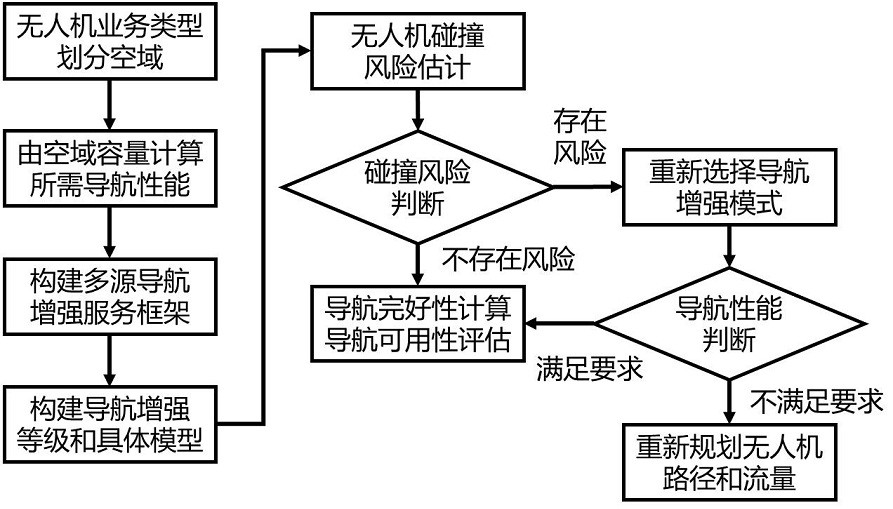
[0061] The present invention provides a multi-source navigation enhancement method suitable for the complex flight of UAVs in low-altitude airspace. The method considers the complex flight scene in low-altitude airspace, and establishes the safe flight capacity of UAVs in low-altitude airspace at different heights by calculating the collision response time. Based on this model, the flight safety protection level is constructed for multi-service and heterogeneous platform UAVs, and layered multi-source fusion navigation enhancement is carried out to meet the requirements of the protection level. The present invention can be effectively applied to complex and dense flying scenes of unman...


PUM


Abstract

The invention provides a multi-source navigation enhancement method suitable for complex flight of a low-altitude airspace unmanned aerial vehicle, which considers a low-altitude airspace complex flight scene, and establishes a capacity model of safe flight of the low-altitude airspace unmanned aerial vehicle at different heights by calculating collision response time, on the basis, a flight safety protection level is constructed for a multi-service and heterogeneous platform unmanned aerial vehicle, and hierarchical multi-source fusion navigation enhancement is carried out by taking the requirement of the protection level as a standard. The method can be effectively suitable for a multi-service-oriented complex and dense flight scene of the unmanned aerial vehicle in a low-altitude airspace, and the operation flow, efficiency and safety of the unmanned aerial vehicle are effectively improved.

Description

technical field [0001] The invention relates to a multi-source navigation enhancement method suitable for complex flight of unmanned aerial vehicles in low-altitude airspace, and belongs to the technical field of unmanned aerial vehicles in low-altitude airspace. Background technique [0002] Low-altitude airspace refers to the flight area below 1,000 meters, which is currently in the process of classified management and gradual and orderly opening. With the rapid growth of the global drone industry, the application and control of low-altitude airspace drones are hot spots and difficulties in related fields. Low-altitude airspace navigation technology uses accurate real-time measurement of positions to ensure safe flight intervals in low-altitude airspace and prevent collisions between aircraft and between aircraft and ground obstacles. [0003] The current low-altitude airspace navigation method is mainly radio non-autonomous navigation, which has the characteristics of hi...

Claims


Application Information

Patent Timeline
Patent Type & Authority Applications(China)
IPC IPC(8): G01C21/16G01C21/20G01S19/45G01S19/46G01S19/47G06F17/16G08G5/00
CPCG01C21/165G01C21/20G01S19/45G01S19/46G01S19/47G06F17/16G08G5/0069
Inventor 刘杨姜荣坤
Owner BEIHANG UNIV
Why Eureka
Try Eureka