
Eureka
For R&D, Eureka makes reading and utilizing patents & technical documents easy.
Eureka AIR
Designed for self-driven R&D workflows. Generate viable solutions, solve complex R&D challenges, empower your innovation with AI.

Eureka Materials
Designed for material experts only. Revolutionize your material R&D, from search, analyze, to developing new materials.

TechResearch
Generate reliable direction feasibility study reports for your R&D in just a few steps.

TechSeek
Discover and master advanced knowledge NOW. Basics, ideas, possibilities, all at once.

TechMind
As an expert in R&D Theories, TechMind can generates customized viable solutions instantly.

TechRisk
Analyze your overall solution with one click, know your potential R&D risks in advance.

TechMonitor
Get weekly tech updates, stay abreast of the latest tech innovations and key insights.
Earth surface tide displacement obtaining method based on GPS and empirical tide model, and application method and system
A tide and displacement technology, applied in the direction of nuclear method, design optimization/simulation, etc., can solve the problems of limited number of GPS observation stations, limited application space, limited monitoring range, tidal load displacement calculation efficiency, etc., to improve measurement accuracy and overcome quantity Constraints and the effect of improving the measurement speed
- Summary
- Abstract
- Description
- Claims
- Application Information
AI Technical Summary
Problems solved by technology
Method used
Image

Examples
Embodiment 1
[0069] Surface tidal displacement in this example Expressed as:
[0070]
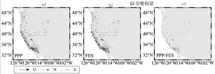
[0071] in, Represents Q1, O1, N2, M2 tidal displacements with high estimation accuracy by dynamic PPP method; Represents the K2, K1, P1 tidal displacements estimated by the ocean tide loading model.
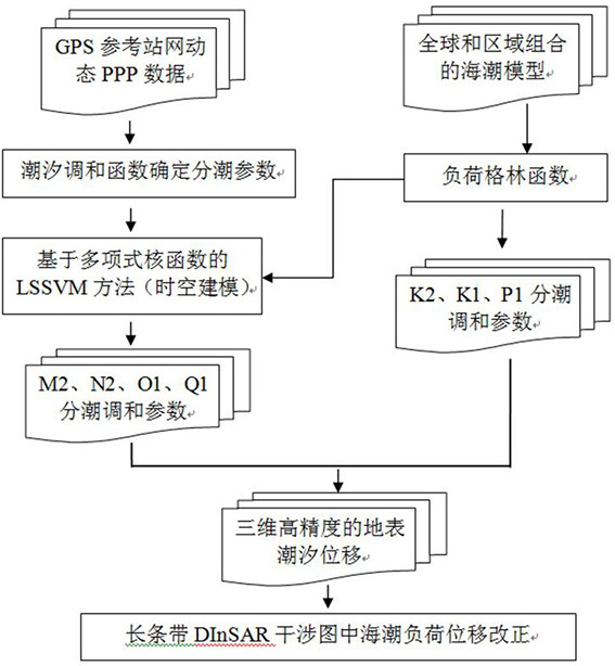
[0072] In this embodiment, the sum of the tidal displacements of the seven main tidal divisions of Q1, O1, N2, M2, K2, K1, and P1 is used as the surface tidal displacement. In other feasible embodiments, other tidal divisions can also be added Displacement, which is not specifically limited in the present invention. Wherein, the present invention obtains Q1, O1, N2, M2 tidal displacement with dynamic PPP method, is about to set Q1, O1, N2, M2 tidal as the target tidal in this embodiment, in other feasible embodiments, can be to It can be adjusted, and the present invention does not specifically limit it.
[0073] Dynamic PPP technology: It can be used to determine the displacement of ocean tidal...
Embodiment 2
[0094] This embodiment provides an application method based on the above method for obtaining surface tidal displacement, which is applied to correcting the differential interferogram, which includes: using the tidal displacement correction model to obtain the surface tidal displacement, and the surface tidal displacement is the ocean tide load displacement Correcting the data; and then using the surface tidal displacement to correct the tidal load displacement corresponding to the corresponding pixel position in the differential interferogram.
Embodiment 3
[0096] This embodiment provides a system based on the above-mentioned method for obtaining surface tidal displacement, which includes:
[0097] Empirical tidal model calculation module, using the empirical tidal model to calculate the harmonic parameters of tidal;
[0098] PPP measurement technology calculation module, based on the observation data of the GPS reference website and using the PPP measurement technology to calculate the harmonic parameters of the tide;
[0099] Prediction model construction module, using the harmonic parameters calculated by the empirical tidal model and the harmonic parameters calculated by the PPP measurement technology to construct a sample data set, and introducing machine learning to carry out network training to obtain the corresponding prediction model of the target tide;
[0100] The tidal displacement correction value calculation module uses the tidal displacement correction model to obtain the surface tidal displacement.
[0101] In so...
PUM
 Abstract
Description
Claims
Application Information
 - R&D Engineer
- R&D Manager
- IP Professional
- Industry Leading Data Capabilities
- Powerful AI technology
- Patent DNA Extraction
Browse by: Latest US Patents, China's latest patents, Technical Efficacy Thesaurus, Application Domain, Technology Topic, Popular Technical Reports.
© 2024 PatSnap. All rights reserved.Legal|Privacy policy|Modern Slavery Act Transparency Statement|Sitemap|About US| Contact US: help@patsnap.com