Navigation system, method and device with detour algorithm

a navigation system and algorithm technology, applied in the field of navigational devices, can solve the problems of increasing system cost, time-consuming, and not performing any course or route recalculation to accommodate the intended, and achieve the effects of low cost, dynamic route calculation capability, and intuitive user experien

Inactive Publication Date: 2005-06-23
GARMIN
View PDF13 Cites 30 Cited by
  • Summary
  • Abstract
  • Description
  • Claims
  • Application Information

AI Technical Summary

Benefits of technology

[0009] The above mentioned problems with navigational devices, as well as other problems, are addressed by the present invention and will be understood by reading and studying the following specification. Systems and methods are provided for a navigational route planning device which is more user intuitive, efficient, timely, and accurate than current low cost systems, without requiring the more expensive system resources. The systems and methods of the present invention offer an improved navigational route planning device which provides a user with more dynamic route calculation capabilities.

Problems solved by technology

As increased system capability also increases system cost, the method of route planning implemented by a navigation device is a function of overall system cost.
Some of these devices may alert the user that they are off course when the user makes a detour, but they do not perform any course or route recalculation to accommodate for the intended or unintended detour in route.
However, these devices require the user to point to, highlight, or draw a box around the segment which the user wants to avoid.
Requiring the user to point to, highlight, or draw a box around the segment which the user wants to avoid is also distracting to do while the user is driving or trying to navigate the route.
This can be time consuming and provide frustration to a user who is likely unfamiliar with the routes surrounding their current location.
Clearly, in many cases halting travel to decide upon a new route is not a viable alternative.
For example, when the user is traveling on an interstate it is entirely impossible to simply stop.
The alternative of pulling off on the shoulder is undesirable and can be dangerous.
Stopping travel is equally undesirable since doing so increases travel time and provides an added inconvenience to the user.
In other instances, such as navigating downtown city streets, the traffic issues alone may prevent the user from stopping their vehicle to decide upon a new route.
As mentioned above, even if the user has the ability to safely stop their vehicle, such as when traveling in a neighborhood, the inconvenience factor is present.
Another problem is that when a device is used to perform a new route calculation from a new position (off of the originally planned route) to a desired destination, the calculation is not going to take into account the reason for the intended or unintended detour.
Thus, the new route does not provide any solution to the need for avoiding the thoroughfare from which the detour was taken.
The lower cost systems currently offer a low degree of accuracy and functionality that is often inadequate for users.

Method used


Image

  • Navigation system, method and device with detour algorithm
  • Navigation system, method and device with detour algorithm
  • Navigation system, method and device with detour algorithm

Examples


Embodiment Construction

[0020] In the following detailed description of the invention, reference is made to the accompanying drawings which form a part hereof, and in which is shown, by way of illustration, specific embodiments in which the invention may be practiced. The embodiments are intended to describe aspects of the invention in sufficient detail to enable those skilled in the art to practice the invention. Other embodiments may be utilized and changes may be made without departing from the scope of the present invention. The following detailed description is, therefore, not to be taken in a limiting sense, and the scope of the present invention is defined only by the appended claims, along with the full scope of equivalents to which such claims are entitled.

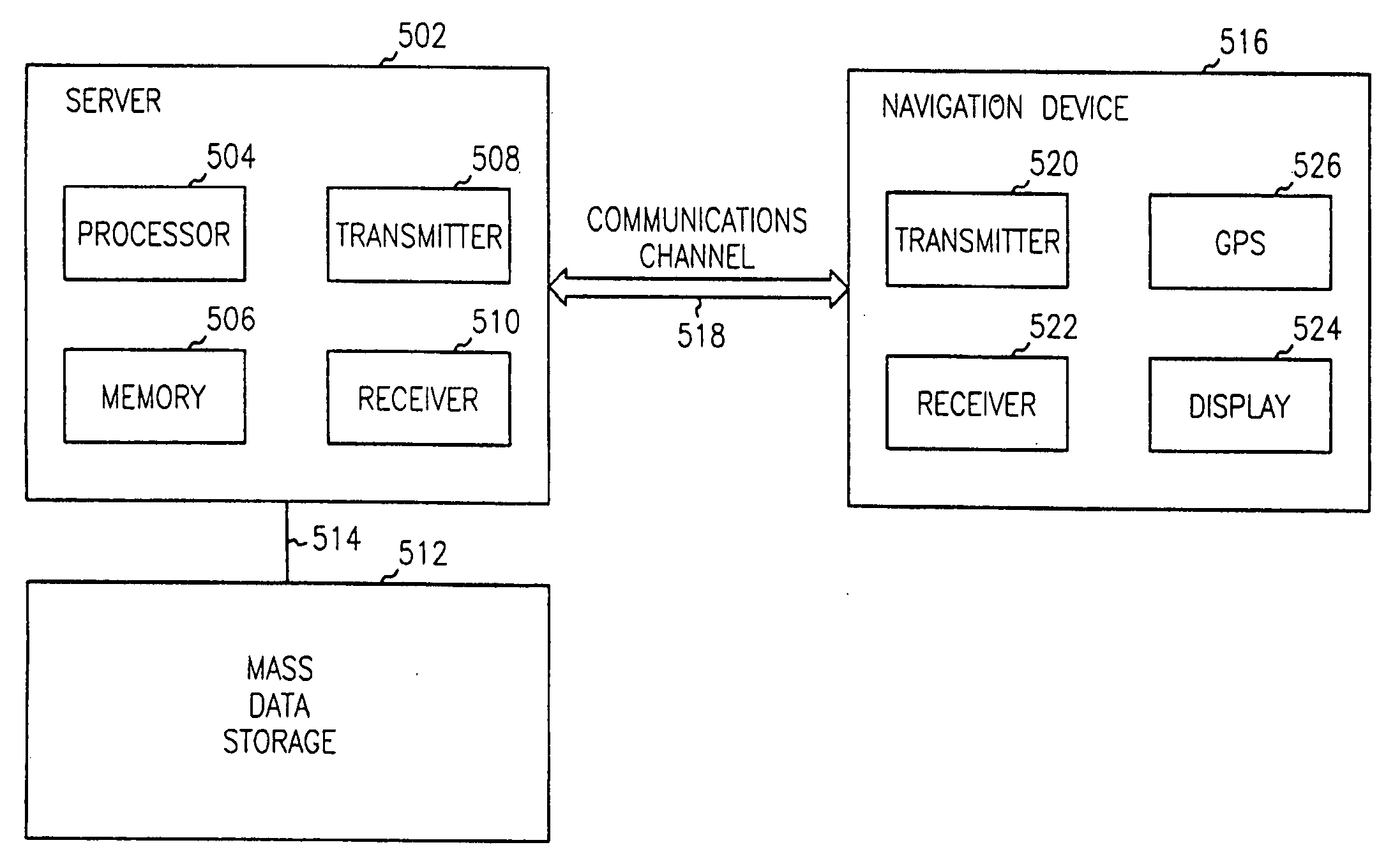
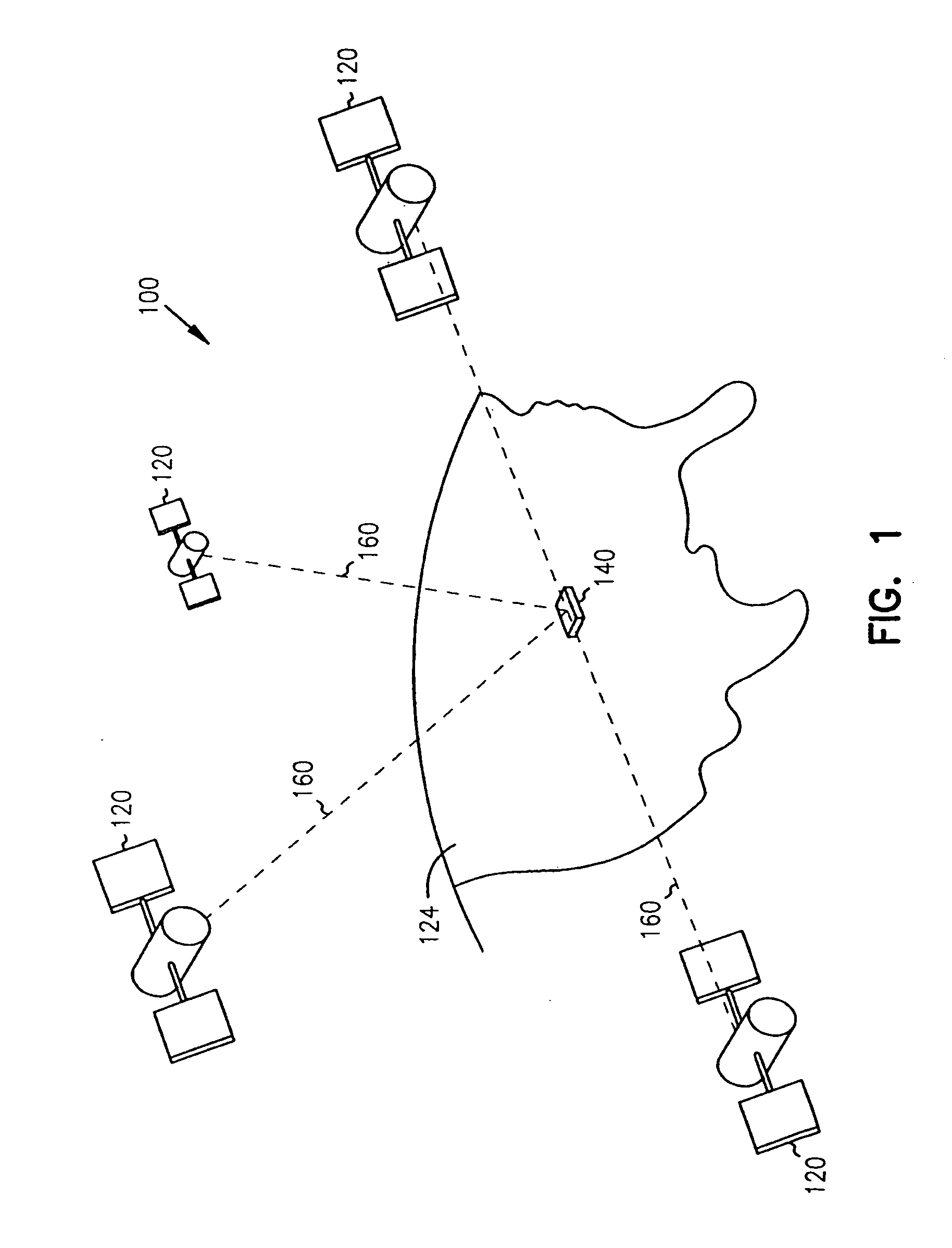
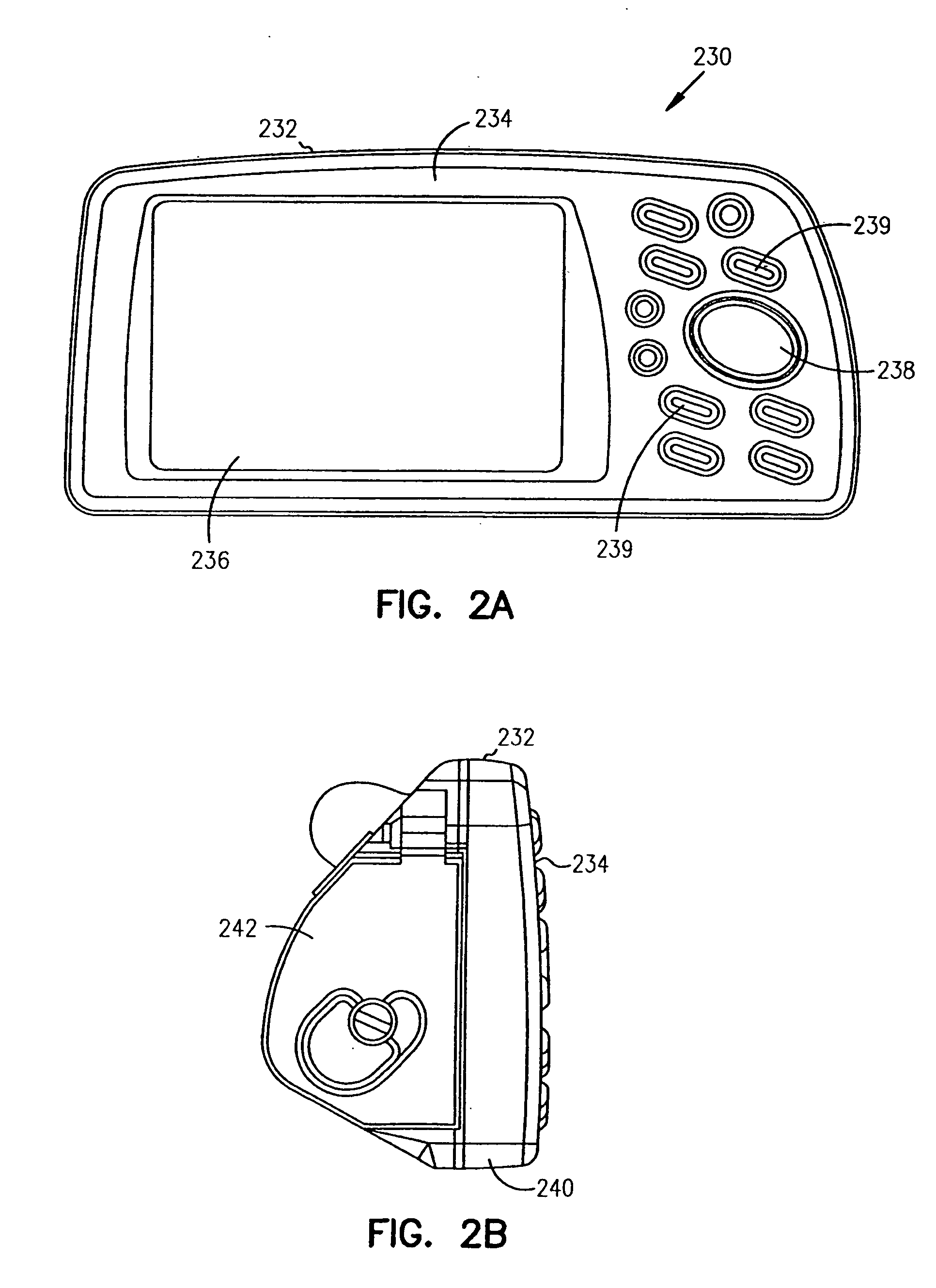
[0021] The present invention is drawn to navigational systems and devices having route calculation capabilities. One type of navigational system includes Global Positioning Systems (GPS). Such systems are known and have a variety of uses. In ge...


PUM


Abstract

Systems, devices and methods are provided for an improved navigational route planning device which provides more understandable, accurate and timely route calculation capabilities. The navigational aid device with route calculation capabilities includes a processor connected to a memory. The memory includes cartographic data and a desired destination, the cartographic data including data indicative of thoroughfares of a plurality of types. A display is connected to the processor and is capable of displaying the cartographic data. The device is adapted to process the device=s location and travel along a planned route. And, the device is adapted to dynamically calculate a new route to the desired destination with a preference for avoiding a particular portion of a thoroughfare or one or more different thoroughfares in a previous route.

Description

CROSS-REFERENCE TO RELATED APPLICATIONS [0001] This application is a divisional and claims priority benefit of U.S. patent application Ser. No. 10 / 701,771, filed Nov. 5, 2003, which is a continuation and claimed priority benefit of U.S. patent application Ser. No. 10 / 028,343, filed Dec. 21, 2001, now U.S. Pat. No. 6,687,615. Thus, this application claims priority benefit of U.S. Pat. No. 6,687,615. Both of the above-identified applications are hereby incorporated by reference.FIELD OF THE INVENTION [0002] The present invention relates generally to navigational devices, and in particular to navigational devices with detour route calculation capabilities. BACKGROUND OF THE INVENTION [0003] Route planning devices are well known in the field of navigational instruments. The method of route planning implemented by known prior art systems depends on the capabilities of system resources, such as processor speed and the amount and speed of memory. As increased system capability also increas...

Claims


Application Information

Patent Timeline
Patent Type & Authority Applications(United States)
IPC IPC(8): G01C21/34G08G1/0968
CPCG01C21/3415G01C21/3461G08G1/096844G08G1/096827G08G1/096838G08G1/096811
Inventor KRULL, JAY DEECHILDS, MICHAELRUNQUIST, SHANE R.
Owner GARMIN
Why Eureka
Try Eureka