Complimentary retrograde/prograde satellite constellation

a satellite constellation and retrograde technology, applied in the field of satellite constellations, can solve the problems of high cost of satellites and launch vehicles for such satellites

Inactive Publication Date: 2007-12-13
NORTH SOUTH HLDG
View PDF15 Cites 25 Cited by
  • Summary
  • Abstract
  • Description
  • Claims
  • Application Information

AI Technical Summary

Problems solved by technology

It is well known that satellites and the launch v...

Method used


Image

  • Complimentary retrograde/prograde satellite constellation
  • Complimentary retrograde/prograde satellite constellation
  • Complimentary retrograde/prograde satellite constellation

Examples


Embodiment Construction

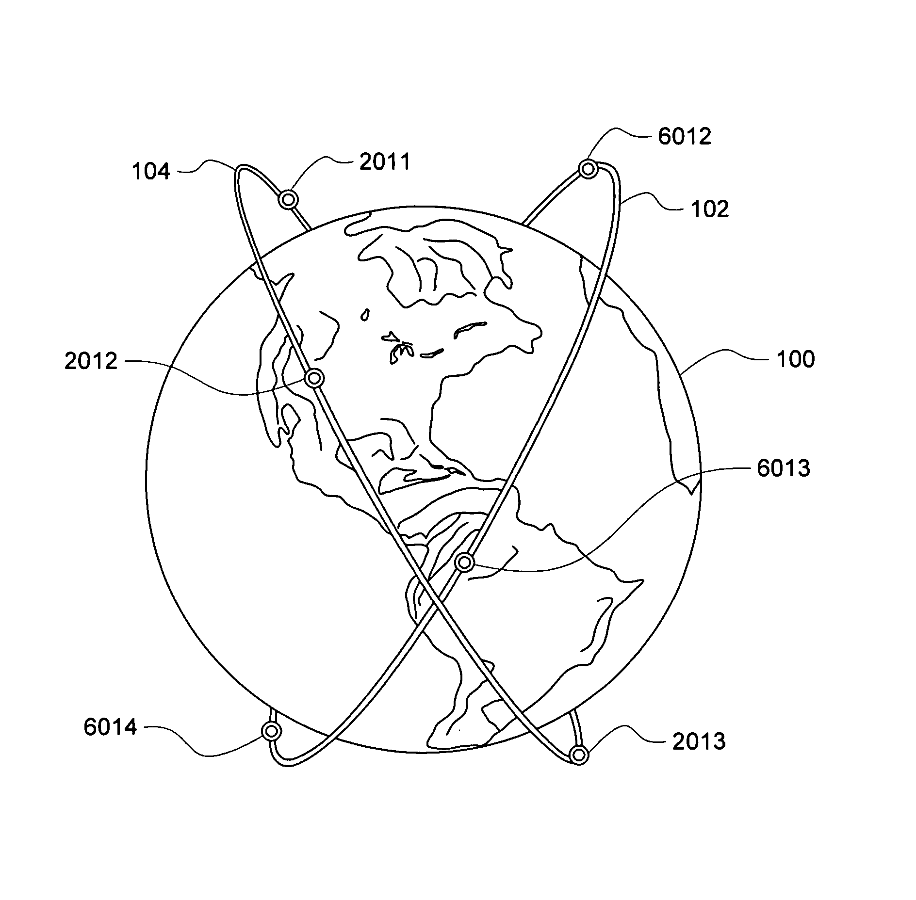
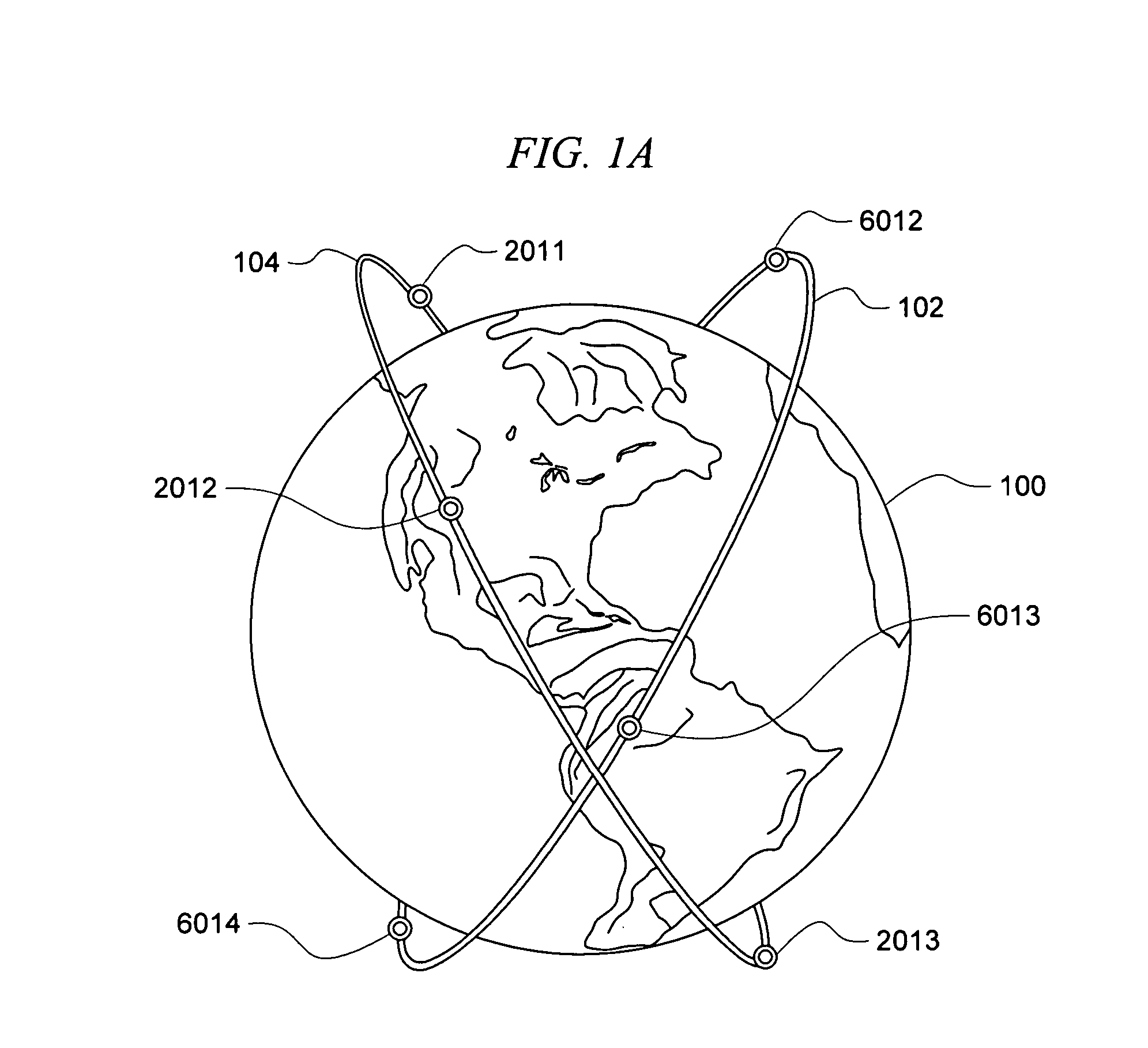
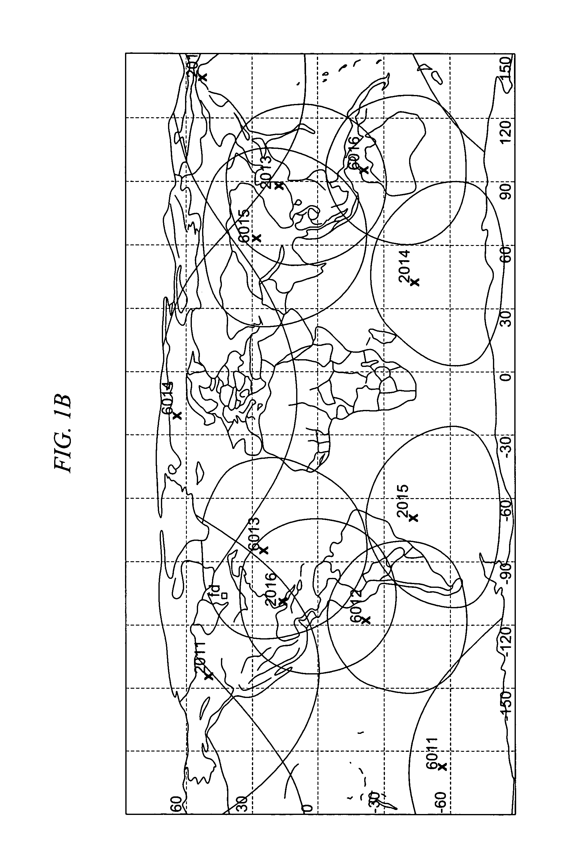
[0021] A challenge of most large-scale satellite projects is the capability to realize mission goals given the allocated budget. The cost for on-orbit delivery of each satellite can be on the order of one billion dollars. A cost control factor for any satellite project is clearly related to number of satellites in the constellation. This invention concerns an optimized constellation that can provide improved satellite visibility and accessibility for a variety of communications and sensing tasks. The optimized constellation (OC) provides better sensor and communication coverage than other approaches and with fewer satellites. The constellation is especially well suited to ICBM / Northern hemisphere threat sensing and corresponding interceptor communications support against such threats and for that reason shall be described herein primarily in relation to that application. Still, it should be understood that the use of the constellation is not limited to this particular application, b...


PUM


Abstract

A method for sensing and monitoring ICBM threats using a constellation of earth orbiting satellites. The method includes arranging a first and a second plurality of threat sensing satellites in earth orbit. The first plurality is selected to have a first prograde orbit plane with a first inclination angle between about 30° to 70° with respect to the earth's equator and an Argument of Perigee equal to about 270°. The second plurality is selected to have a first retrograde orbit plane with a second inclination angle between about 110° to 150° with respect to the earth's equator and an Argument of Perigee equal to about 270°. The second inclination angle is selected to be a symmetric conjugate of the first inclination angle. The first and second plurality of threat sensing satellites are distributed respectively within the first prograde and first retrograde orbits with a Walker distribution of T/P/1. Synchronization of a plurality of epochs of the first plurality of satellites with a plurality of epochs of the second plurality of satellites is performed to provide uniform inter-plane satellite spacing for improved monitoring of an ICBM threat.

Description

[0001] This application is a divisional application of co-pending U.S. patent application Ser. No. 10 / 656,951 filed on Sep. 4, 2003.BACKGROUND OF THE INVENTION [0002] 1. Statement of the Technical Field [0003] The inventive arrangements relate generally to the field of satellite systems, and more particularly to a constellation of satellites. [0004] 2. Description of the Related Art [0005] Earth satellites are used for a wide variety of civilian and military purposes. In the civilian realm, these purposes can include weather, communications, mapping, and resource exploration. Satellites used for military purposes can serve as communication links, surveillance platforms and weapons systems. Global positioning system (GPS) satellites are commonly used for both civilian and military purposes. [0006] In many instances, two or more satellites must operate in a cooperative arrangement in order to satisfy mission requirements. Such groups of satellites are called constellations. For exampl...

Claims


Application Information

Patent Timeline
IPC IPC(8): B64G1/10
CPCF41H11/02B64G1/1085
Inventor FURMAN, MICHAEL J.
Owner NORTH SOUTH HLDG
Why Eureka
Try Eureka