
Dual-purpose GIS data system

a data system and dual-purpose technology, applied in the field of geospatial data collection networks, can solve the problems of limited use of gis, high cost of deploying data collectors for gis systems, and large number of dedicated gis data collectors

Active Publication Date: 2008-10-23
TRIMBLE NAVIGATION LTD
View PDF12 Cites 57 Cited by
  • Summary
  • Abstract
  • Description
  • Claims
  • Application Information

AI Technical Summary

Benefits of technology

[0051]In embodiments of the present invention, a GIS data collector application 111 is uploaded into mobile electronic device 110 which then enables mobile electronic device 110 to perform GIS data collector functions. Also uploaded onto mobile electronic device 110 is a data dictionary 112. In embodiments of the present invention, data dictionary 112 is a subset of a larger data dictionary which is managed by GIS data network 140. As will be explained in greater detail in Section III below, a data dictionary comprises definitions of feature types having measurable attributes as well as information on how those attributes should be collected. For example, information on how the attributes should be collected may include, but are not limited to, default values, minimum / maximum values, whether an attribute is optional or mandatory, etc. In embodiments of the present invention, the attributes and feature types comprising data dictionary 112 are selected at GIS data network 140 and stored upon storage and forwarding server 130 as data dictionary 143a. When communications are first established between mobile electronic device 110 and storage and forwarding server 130, a copy of data dictionary 143a is automatically sent to mobile electronic device 110 where it is stored as data dictionary 112. Thus, in embodiments of the present invention, data dictionary 112 will typically be sent to mobile electronic device 110 once, with occasional updates as needed. However, embodiments of the present invention also facilitate sending entirely new, or additional, data dictionaries to mobile electronic device 110 as well.

Problems solved by technology

However, there are several factors which limit the use of GIS.
One factor is the cost of deploying data collectors for GIS systems.
Dedicated GIS data collectors are often large (e.g., up to 4-5 pounds) and expensive ($1500-$5000) per unit.
Additionally, at the end of the day, bottlenecks in downloading the collected data may occur if all of the users are at the office at the same time.
Another disadvantage of conventional dedicated GIS data collectors is that they often utilize a complicated user interface.
Many GIS data collectors have dozens of input buttons for operators to learn and utilize an equally complicated user interface for navigating the data collector application.
Also, if the operators do not use the GIS data collector frequently, they can forget the functions associated with some of the buttons, or how to navigate the user interface.
As a result of the above stated problems, entities which utilize GIS data collection systems are often limited in the number of GIS data collectors they can deploy in the field.
Whether it is due to the cost of the data collectors themselves, the additional equipment needed to support the deployment of the data collectors, or the cost of training operators, the ability to collect geo-spatial data in a timely manner is limited to a small percentage of the available workforce.

Method used


Image

  • Dual-purpose GIS data system
  • Dual-purpose GIS data system
  • Dual-purpose GIS data system

Examples


Embodiment Construction

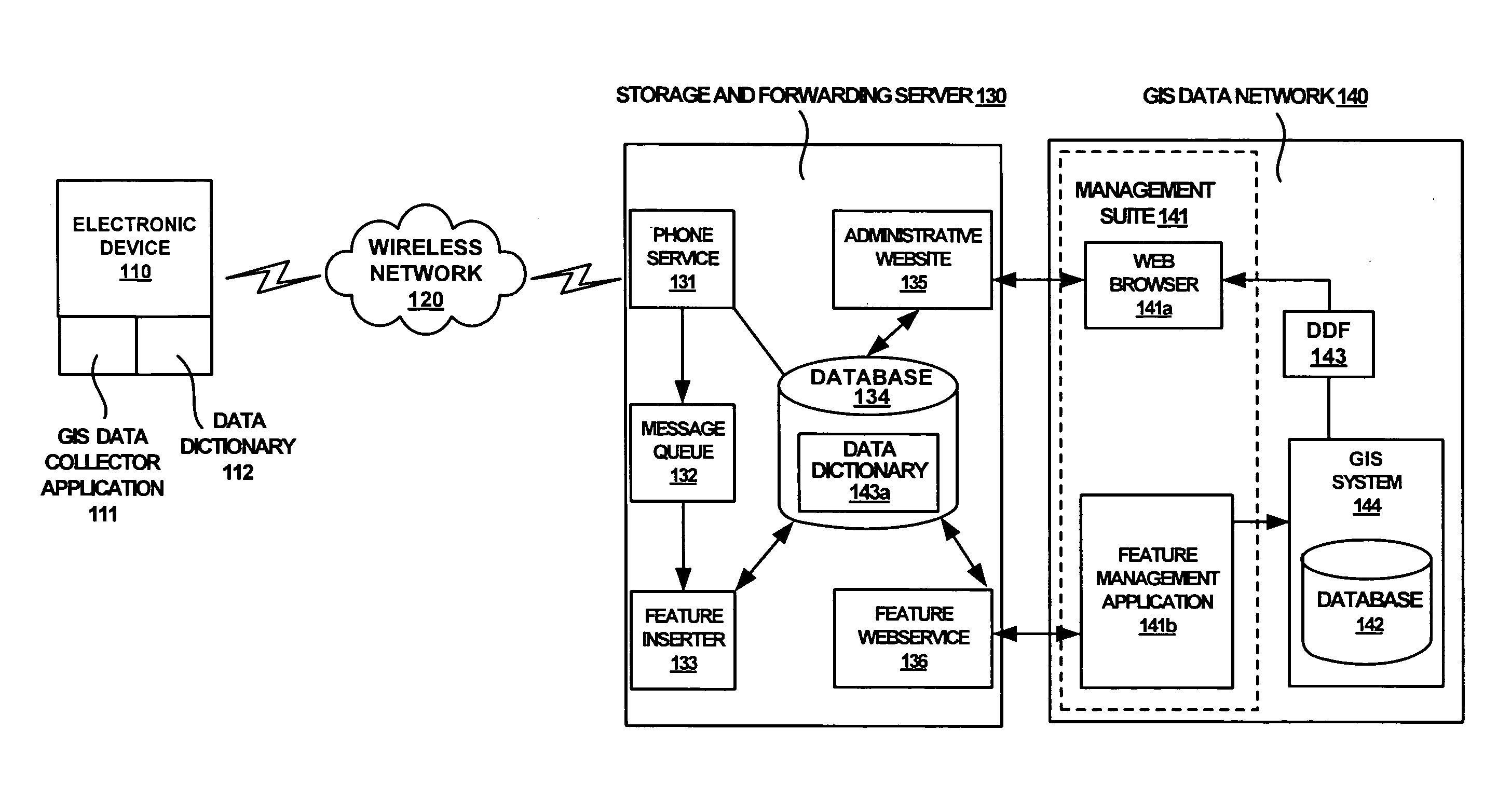
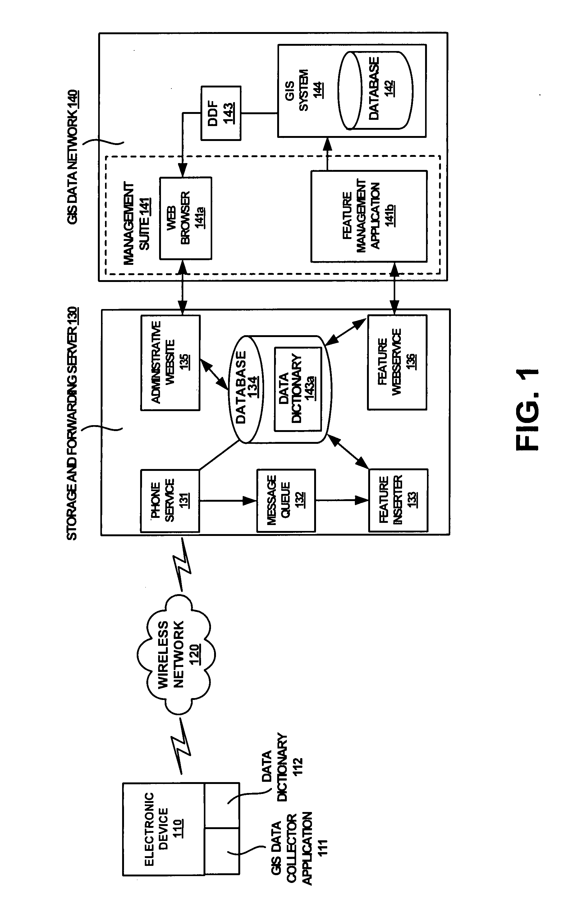
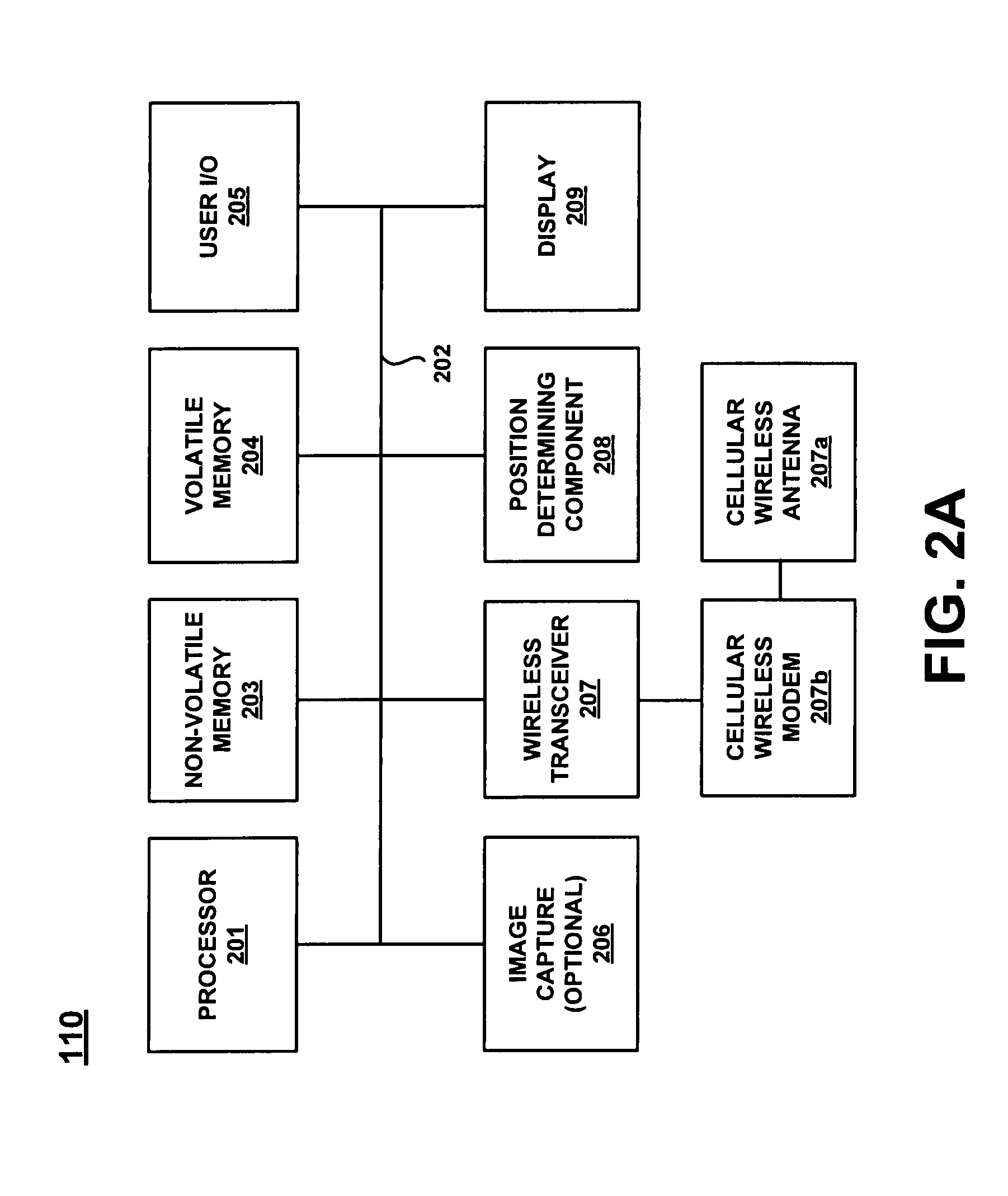
[0045]Reference will now be made in detail to embodiments of the present invention, examples of which are illustrated in the accompanying drawings. While the present invention will be described in conjunction with the following embodiments, it will be understood that they are not intended to limit the present invention to these embodiments alone. On the contrary, the present invention is intended to cover alternatives, modifications, and equivalents which may be included within the spirit and scope of the present invention as defined by the appended claims. Furthermore, in the following detailed description of the present invention, numerous specific details are set forth in order to provide a thorough understanding of the present invention. However, embodiments of the present invention may be practiced without these specific details. In other instances, well-known methods, procedures, components, and circuits have not been described in detail so as not to unnecessarily obscure aspe...


PUM


Abstract

Embodiments of the present invention recite method for implementing a dual purpose Geographic Information Systems (GIS) network. In one embodiment, a first data stream which is compatible with a dedicated GIS data collection device is generated. The method further comprises generating a second data stream which is compatible with a mobile electronic device configured for collecting GIS data and which was not originally intended for use as a GIS data recording device.

Description

CROSS REFERENCE TO RELATED APPLICATIONS[0001]The present patent application is a continuation in part of U.S. patent application Ser. No. 11 / 788,662 filed Apr. 19, 2007, entitled “Method and System for Creating a Flexible GIS Data Collection Network,” by Paul Manson, Bruce James, Michelle Bergen, Robert Allan, John Rogers, Peter France, attorney docket number TRMB 1810, assigned to the assignee of the present invention, and which is hereby incorporated by reference in its entirety herein.[0002]U.S. patent application No. ______ entitled “Method and System for Implementing a GIS Data Collection Network,” by Paul Manson, Bruce James, Michelle Frye, Robert Allan, John Rogers, Peter France attorney docket number TRMB 2178, assigned to the assignee of the present invention, filed ______,and which is incorporated by reference in its entirety herein.[0003]U.S. patent application No. ______ entitled “Method and System for Upgrading a Legacy Cellular Device,” by Paul Manson, Bruce James, Mic...

Claims


Application Information

Patent Timeline
IPC IPC(8): G06F17/30H04W4/02
CPCG06F17/30241H04W4/02H01L2224/2919H01L2924/0665H01L2924/00H04L67/34H04L67/04H04L67/18G06F16/29H04L67/52
Inventor MANSON, PAUL ROBINJAMES, BRUCE STEPHENFRYE, MICHELLE LYNNALLAN, ROBERT MURIEROGERS, JOHN FRANCISFRANCE, PETER GLEN
Owner TRIMBLE NAVIGATION LTD
Features
  • Generate Ideas
  • Intellectual Property
  • Life Sciences
  • Materials
  • Tech Scout
  • Unparalleled Data Quality
  • Higher Quality Content
  • 60% Fewer Hallucinations
Learn More