Data mining in a digital map database to identify decreasing radius of curvature along roads and enabling precautionary actions in a vehicle

a technology of digital map database and data mining, which is applied in the direction of traffic control system, navigation instruments, instruments, etc., can solve the problems of difficult to obtain consistent information about traffic accidents on roads in a large geographic region, such as the entire united states or europe, and achieve the effect of increasing control authority and sensitivity

Active Publication Date: 2009-12-03
HERE GLOBAL BV
View PDF99 Cites 84 Cited by
  • Summary
  • Abstract
  • Description
  • Claims
  • Application Information

AI Technical Summary

Benefits of technology

[0006]To address these and other objectives, the present invention comprises a feature that enables taking a precautionary action in a vehicle as the vehicle approaches the location of a curve that has a decreasing radius of curvature. The precautionary action may be a warning message provided to the vehicle driver to alert the vehicle driver about the curve with the decreasing radius of curvature so that the vehicle driver can pay extra attention. Alternatively, the precautionary action may be an actual modification of the operation or control of the vehicle, such as braking, accelerating, or maneuvering the vehicle, or activating a sensor. Alternatively, the precautionary action may be providing an input to an algorithm that also processes inputs from other sensors for taking such actions. In another alternative, the precautionary action may include a combination of any of these aforementioned actions.
[0007]According to another aspect, a database that represents the road network is used to determine locations where there are curves with decreasing radii of curvature. Then, precautionary action data is added to the database to indicate each location at which a precautionary action is to be provided about a curve with a decreasing radius of curvature.
[0008]According to further aspects, a precautionary action system installed in a vehicle uses this database, or a database derived therefrom, in combination with a positioning system, to determine when the vehicle is at a location that corresponds to the location where a precautionary action should be taken. When the vehicle is at such a location, the precautionary action is taken, such as providing a warning to the vehicle operator, as the vehicle is approaching a curve with a decreasing radius of curvature. Alternatively, the precautionary action may consist of an actual modification of the operation or control of the vehicle, such as braking, accelerating, or maneuvering the vehicle, or activating a sensor. Alternatively, the precautionary action may include providing an input to an algorithm that also processes inputs from other sensors for taking such actions. Alternatively, the precautionary action may be an adjustment of sensitivities of other ADAS applications such as increasing the control authority and sensitivity of a lane departure warning or control system to lane edge approach and violation. In another alternative, the precautionary action may include a combination of any of these aforementioned actions.

Problems solved by technology

Accordingly, it is difficult to obtain consistent information about traffic accidents on roads in a large geographic region, such as the entire United States or Europe.
Moreover, data indicating locations where a statistically large number of traffic accidents occur may not indicate the causes of the accidents or how accidents can be avoided.

Method used


Image

  • Data mining in a digital map database to identify decreasing radius of curvature along roads and enabling precautionary actions in a vehicle
  • Data mining in a digital map database to identify decreasing radius of curvature along roads and enabling precautionary actions in a vehicle
  • Data mining in a digital map database to identify decreasing radius of curvature along roads and enabling precautionary actions in a vehicle

Examples


Embodiment Construction

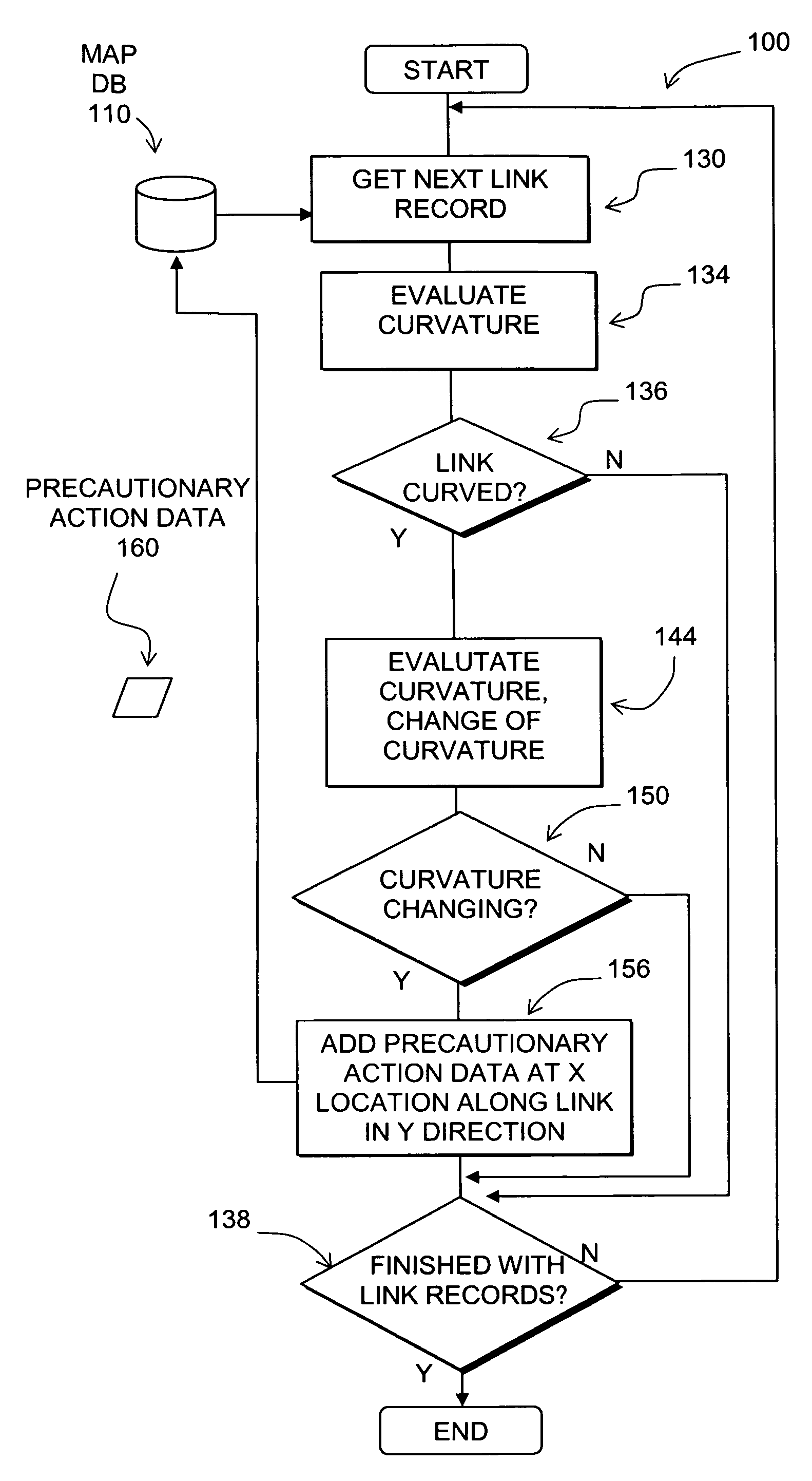
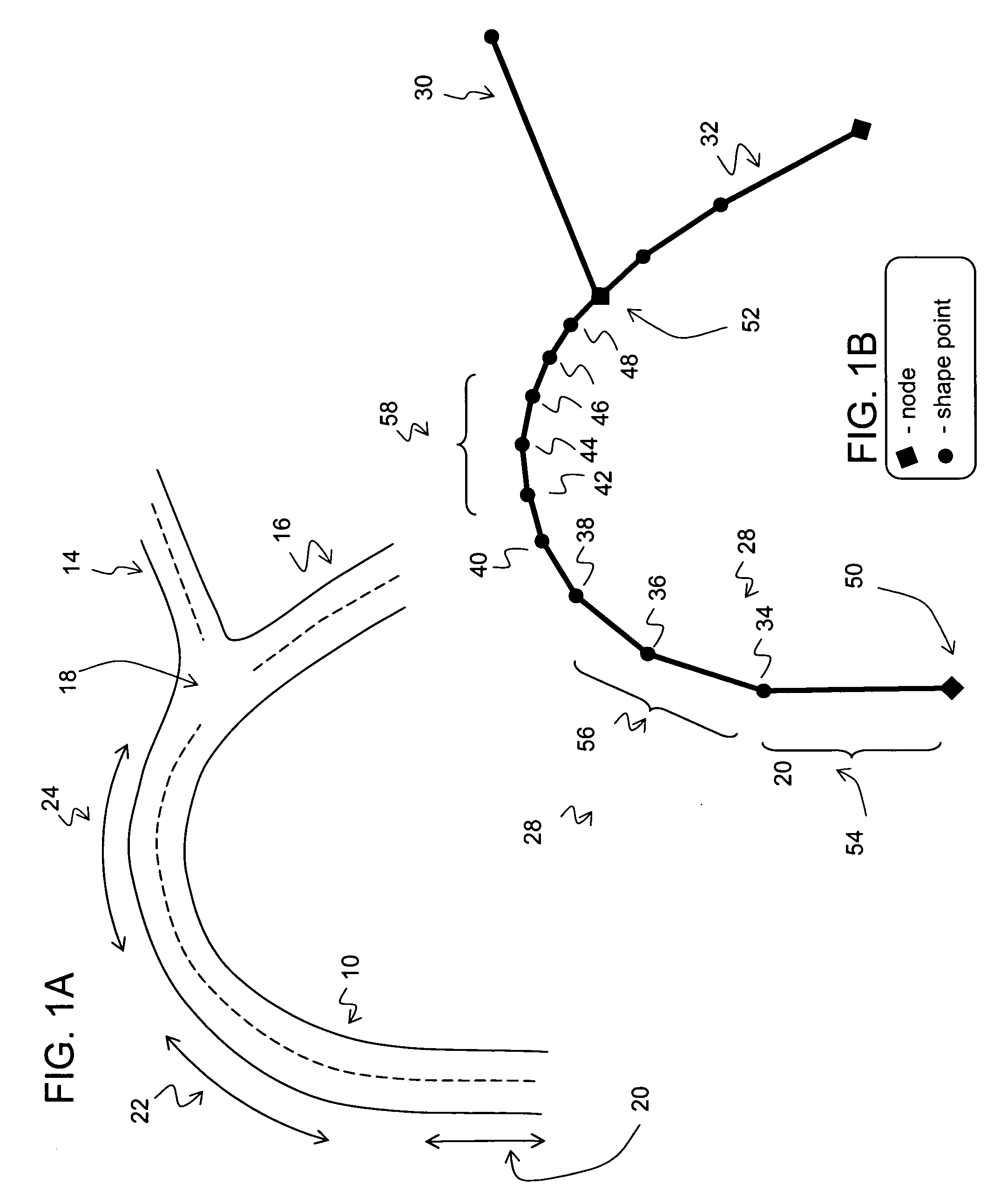
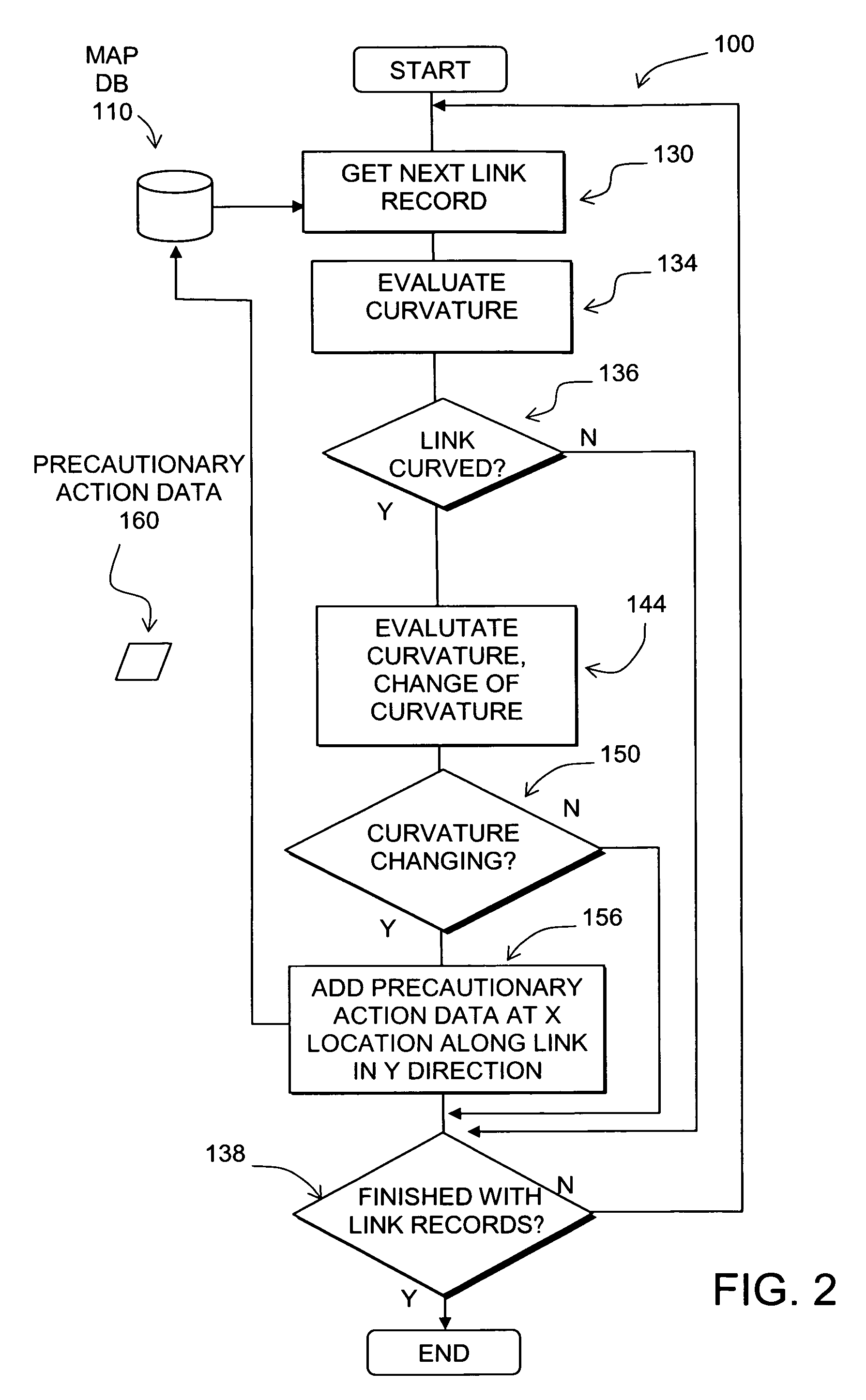
[0015]FIG. 1A depicts road segments 10, 12 and 14. The road segments 10, 12 and 14 meet at an intersection 16. As shown in FIG. 1A, the road segment 10 is curved. The degree by which a road segment curves is described by its curvature. There are various ways to indicate or measure curvature. Curvature refers to a property of a road segment and is an indication of how much the road is curved. As shown in FIG. 1A, the road segment 10 starts out with a straight portion 18, followed by a portion 20 that is moderately curved, which is followed a portion 22 that is more curved.

[0016]FIG. 1B is an illustration of how the road segments in FIG. 1A are represented by data contained in a map database (such as the database 110 in FIG. 2). The road segments are each represented by a data record that defines a line that extends between two endpoints, or nodes. The location of the road segment is defined by the data indicating the locations (e.g., geographic coordinates, including altitude) of the...


PUM


Abstract

Disclosed is a feature for a vehicle that enables taking precautionary actions in response to conditions on the road network around or ahead of the vehicle, in particular, a curved portion of a road where the curvature increases between adjacent curved sections. A database that represents the road network is used to determine locations where curvature between adjacent curved sections increases. Then, precautionary action data is added to the database to indicate a location at which a precautionary action is to be taken about the location where curvature increases. A precautionary action system installed in a vehicle uses this database, or a database derived therefrom, in combination with a positioning system to determine when the vehicle is at a location that corresponds to the location of a precautionary action. When the vehicle is at such a location, a precautionary action is taken by a vehicle system as the vehicle is approaching a location where the curvature increases.

Description

REFERENCE TO RELATED APPLICATION[0001]The present patent application is related to the copending patent application Ser. No. ______, filed on the same date, entitled “DATA MINING TO IDENTIFY LOCATIONS OF POTENTIALLY HAZARDOUS CONDITIONS FOR VEHICLE OPERATION AND USE THEREOF,” Attorney Docket No. N0260US, the entire disclosure of which is incorporated by reference herein.BACKGROUND OF THE INVENTION[0002]The present invention relates to a method and system that enables taking a precautionary action in a vehicle, such as providing a warning to a vehicle driver about a potentially difficult or hazardous driving condition on the road network.[0003]Advanced driver assistance systems (“ADAS”), including active safety and fuel economy systems, have been developed to improve the comfort, efficiency, safety, and overall satisfaction of driving. Examples of these advanced driver assistance systems include adaptive headlight aiming, adaptive cruise control, lane departure warning and control, c...

Claims


Application Information

Patent Timeline
Patent Type & Authority Applications(United States)
IPC IPC(8): G06F17/30G01C21/26
CPCB60W40/072B60W40/076G06F17/30241G01C21/3697G01C21/26G06F16/29
Inventor DENARO, ROBERT
Owner HERE GLOBAL BV
Why Eureka
Try Eureka