To perform scientific, collaborative experimentation and exploration over any significantly large geographic or
spatial domain, deploy a large number of field devices to provide sufficient resolution, or track a moving or dynamic phenomenon, or in cases where phenomena to be assessed are in remote areas and / or are rapidly changing, it is difficult and potentially infeasible using conventional methods.
If feasible, the methods are prone to unreliable performance and overwhelming complexity.
Achieving a practical level of assurance that the scientific experimentation and exploration will be reliably achieved can be a complex, time-consuming, and expensive undertaking.
Certain location like Antarctica, oceans, wetlands, deserts, rain forests, low-earth
orbit, and hazardous areas can present their own unique challenges.
The study of geographically widespread phenomena (e.g.
climate change) presents the additional challenge of
scalability to many conventional approaches.
Further, certain circumstances, such as those involving data sensing and gathering in fragile ecosystems and
wildlife habitats, are sensitive to human presence.
The military theater often presents both a remote and hazardous environment, where information from the theater of battle and
command and control over action taken in the battle theater is often complex and rapidly changing.
Poor or inadequate information from or about the rescue area, a portion or all of which may be remote or effectively remote due to hazards, can contribute to
loss of life or damage the environment or property.
Further compounding the situation is that the normal communications systems, utilities and information-gathering services may be unavailable after a disaster, which may be widespread or in remote areas (e.g. an
oil spill or fire in the Alaskan
wilderness).
In the transportation and
homeland security arenas, sensing and monitoring factors affecting land, sea, air, and orbital traffic, and effecting adequate
system and signaling control over transportation under both normal and hazardous conditions is a daunting challenge.
Many locations do not have terrestrial transportation
monitoring and control infrastructure in place, as it is expensive and requires years of planning.
Traditional satellites, costing millions of dollars, do not offer the desired degree of control over their functions (communications,
instrumentation, and actuation-control), and their quantities are too small to offer the tremendous access needed by large populations of experimenters or those seeking to flexibly gather data through large arrays of sensors.
While conventional satellites and ground stations are fine as a communications medium for high volumes of phone calls, data, and for other widespread
instrumentation systems that are already operational, they cannot be easily or economically coopted for large volumes of coordinated research and development or complex
scientific experiment.
Traditional ground stations have fundamental barriers which limit access to their use in Low Earth Orbiting Satellites (“LEOSAT”) based experimentation.
First, traditional ground stations using powerful computer servers, sophisticated multiband radios, and high-
gain directional tracking antennas can cost thousands of dollars and are generally stationary.
Second, traditional ground stations require significant knowledge to use and are hence not very transparent or easily or quickly deployed by students, experimenters, or untrained personnel.
Third, traditional ground stations are few in number and are not easily deployed in large numbers on large geographic scales.
Fourth, students and educators may not be familiar with ground stations.
Finally, the requirement to have a
ground station in order to participate in LEOSAT and / or cube-
satellite based experimentation or operations is in itself a limitation.
Further, the time from experimental concept to on
orbit implementation tends to be much shorter in Cube-satellites than the conventional large-satellite approach to doing on-orbit science and experimentation.
This being the case, it is nevertheless challenging to incorporate many of the functions and the functional performance of traditional satellites into the small inexpensive cube-satellite design.
Certain functions (e.g. providing power for onboard systems, propulsion, stabilization, and orientation of the satellites while in orbit, and high performance and directional communications) are now fairly routine in traditional satellites, but become difficult to achieve in the economical cube-satellite approach.
Cube-satellite performance is generally substandard as compared to conventional commercial and scientific satellites.
A salient difficulty in cube-satellites is the ability to achieve precise on-orbit stabilization and orientation (i.e.
attitude control and hence control of its radio pattern direction).
But this precise orientation in cube-satellites is relatively difficult to achieve.
This makes cube-satellite communications using the higher-
gain dipoles or directional antennas particularly hard to achieve.
In essence, it becomes hard to keep the cube-satellite antenna's major radio lobes pointed in the direction of the
ground station.
This is made all the more difficult as satellites are normally required to spin for thermal
equalization on all surfaces.
A particularly challenging problem is that the cube-satellite may spin somewhat erratically or tumble about at several RPMs once deployed.
This means the satellite antenna's radio patter goes into and out of alignment with the ground
station, causing deep period nulls in the radio strength, and radio alignment with the ground stations lasting for mere seconds in some cases.
The deep nulls may interrupt the radio link between cube-satellite and a given ground
station, and any portion of any messages in communication may be lost or the message may be dropped entirely.
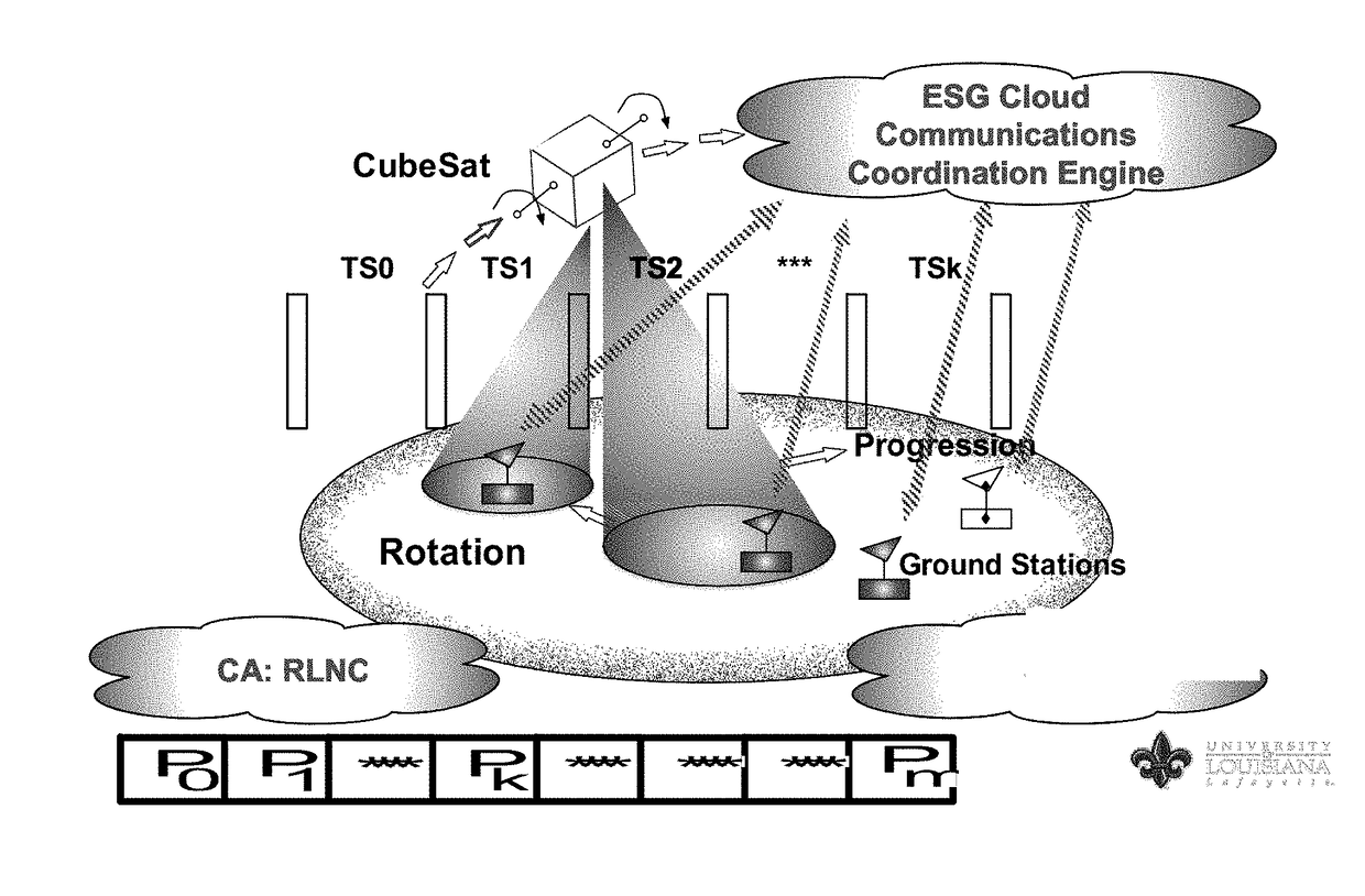
Another issue limiting access to satellite-based experimentation using cube-satellite(s) and LEOSATs in general is the short temporal communications window, i.e. the short window of time available for communicating with the satellite during its flyover from the perspective of a given single ground
station.
Hence, using the traditional single ground station approach to LEOSAT and / or cube-satellite communications limits access to on-orbit experimentation in the case of LEOSATs and / or cube-satellites.
Further, Traditional ground stations designed for communicating with LEOSATs or cube-satellites normally include relatively expensive computer servers and relatively expensive, high-
gain directional tracking antennas so as to attempt to maintain the communications link between ground and satellite during the satellite's 15 minute orbital overhead pass.
They may cost hundreds or even thousands of dollars, are generally stationary, and require housing facilities.
They are not readily scalable to large numbers of units, limiting broader access to low-end LEOSAT or cube-satellite communications or satellite-based experimentation.

