System and method for generating visual education maps

a visual education and mapping technology, applied in the field of digital mapping of education data, can solve the problems of limited interactivity and analysis capabilities, simple tagging does not create interactive visual educational maps or mapped datasets, and methods for mapping educational data

Inactive Publication Date: 2017-11-02
WILLCOX KAREN E +1
View PDF2 Cites 12 Cited by
  • Summary
  • Abstract
  • Description
  • Claims
  • Application Information

AI Technical Summary

Benefits of technology

[0016]In one example, the method further comprises generating traffic analytics corresponding to the number of students who have taken the one or more routes.
[0017]Another aspect of the disclosure provides a system for generating visual educational maps, comprising: a processor; and a memory having instructions stored thereon such that, wh

Problems solved by technology

This simple tagging does not create interactive visual educational maps or mapped datasets.
Existing methods for mapping of educational data have disadvantages of limited interactivity and analysis capabilities, and extremely limited flexibility in interacting with different datasets.
This manual process requires prior-hand knowledge of the data, results in hard-to-read rows of numbers, and requires technical exp

Method used


Image

  • System and method for generating visual education maps
  • System and method for generating visual education maps
  • System and method for generating visual education maps

Examples


Embodiment Construction

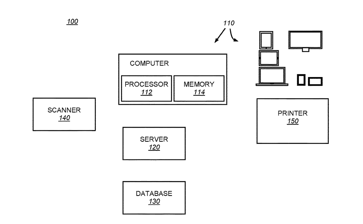
[0043]The present disclosure provides a system and methods that implement digital educational mapping with features analogous to that found in digital cartography: multi scale viewing (zoom), smooth panning, interactive map search, directions, GPS, GPS trace, traffic, and layers.

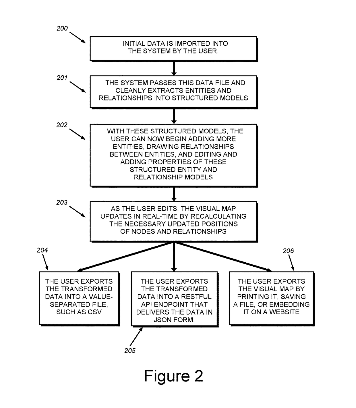
[0044]As used herein, the term “interactive visual educational map” refers to maps that are visualizations, automatically drawn by computer, interactive, and represented in a graph or network form in which entities are drawn as nodes or vertices and relationships among entities as edges among nodes. As used herein, “mapped data” refers to the transformed set of data that contains additional information (e.g., relationships amongst entities, new entities, etc.) that is an output of editing the data on the system.

[0045]This system enables rich interactive capabilities and deep analysis of entities and entity relationships. The output of this system enables user-created visual educational maps to be physically ...


PUM


Abstract

A system and methods to implement a computer program for mapping with modified features from web mapping and digital cartography applied to educational maps, to produce visual maps and mapped data for adaptive learning, competency-based education, and academic scheduling business cases.

Description

FIELD OF THE INVENTION[0001]The invention relates generally to digital mapping of education data.BACKGROUND OF THE INVENTION[0002]Educational mapping is a useful pedagogical practice that identifies entities within a set of data and draws relationships among these entities. Visual educational maps are graphical representations of the resulting mapped data comprising entities and relationships.[0003]Current practice is typically to tag learning resources (such as video lectures, reading notes, assessment questions, etc.) with the learning outcomes that the resource addresses. This simple tagging does not create interactive visual educational maps or mapped datasets.[0004]Existing methods for mapping of educational data have disadvantages of limited interactivity and analysis capabilities, and extremely limited flexibility in interacting with different datasets. In addition, many of these existing educational “maps” are text-based rendering of education data (e.g., bulleted lists of o...

Claims


Application Information

Patent Timeline
IPC IPC(8): G06Q50/20G09B5/00
CPCG09B5/00G06Q50/2053
Inventor WILLCOX, KAREN E.HUANG, LUWEN
Owner WILLCOX KAREN E
Why Eureka
Try Eureka